Shrirampur taluka

Last updated

Shrirampur taluka
Shrirampur Tehsil in Ahmednagar District.jpg
Location of Shrirampur in Ahmednagar district in Maharashtra
CountryFlag of India.svg  India
State Maharashtra
District Ahmednagar
Headquarters Shrirampur
Area
  Total569.87 km2 (220.03 sq mi)
Population
 (2011)
  Total287,500
  Density500/km2 (1,300/sq mi)
Demographics
   Literacy rate 68.95%

Shrirampur taluka, is a taluka in Shrirampur subdivision of Ahmednagar district in Maharashtra state of India. [1]

Contents

Area

The table below shows area of the taluka by land type. [2]

Type of LandArea (km2) % of Total Area
Agriculture507.3489.03
Forest00
Other62.5310.97
Total569.87100

Villages

There are around 56 villages in Shrirampur taluka. For a list of villages see Villages in Shrirampur taluka . Belapur is one of the important places and a developed village in the taluka.

Population

Religions in Shrirampur taluk (2011) [3]
ReligionPercent
Hinduism
82.73%
Islam
12.94%
Buddhism
1.29%
Jainism
1.27%
Christianity
0.96%
Sikhism
0.51%
Other or not stated
0.30%

Shrirampur taluka has a population of 287,500 according to the 2011 census. Shrirampur had a literacy rate of 82.12% and a sex ratio of 962 females per 1000 males. 89,282 (31.05%) lived in urban areas. Scheduled Castes and Scheduled Tribes make up 19.29% and 6.80% of the population respectively. [4]

Languages of Shrirampur taluk (2011) [5]

   Marathi (81.04%)
   Hindi (6.99%)
   Urdu (6.44%)
   Marwari (1.40%)
   Vadari (0.92%)
  Others (3.21%)

At the time of the 2011 Census of India, 81.04% of the population in the district spoke Marathi, 6.99% Hindi, 6.44% Urdu, 1.40% Marwari and 0.92% Vadari as their first language. [5]

Rain Fall

The table below details rainfall from 1981 to 2004. [6]

YearRainfall (mm)
1981880
1982373
1983668
1984350
1985392
1986335
1987582
1988546
1989585
1990752
1991401
1992456
1993566
1994463.9
1995508
1996611
1997312
1998819
1999315
2000354
2001341
2002391
2003313
2004485

Best places to visit in ukkalgaon==See also==

Related Research Articles

<span class="mw-page-title-main">Gondia district</span> District of Maharashtra in India

Gondia district is an administrative district in the state of Maharashtra in India. The district headquarter is located at Gondia. The district occupies an area of 5,234 km2 (2,021 sq mi) and has a population of 1,322,507 of which 11.95% were urban. The district is part of Nagpur Division. There are 8 Talukas in Gondia District. Gondia Airport is second airport in Vidharbha region and serves city of Gondia.

<span class="mw-page-title-main">Ahmednagar district</span> District in Maharashtra, India

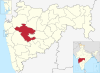
Ahmednagar district is the largest district of Maharashtra state in western India. The historical Ahmednagar city is the headquarters of the district. Ahmednagar and Sangamner are the largest cities in the district. It was the seat of the Ahmednagar Sultanate of late medieval period. This district is known for the towns of Shirdi associated with Sai Baba, Meherabad associated with Meher Baba, Shani Shinganapur with Shanidev, and Devgad with Lord Dattatreya. Ahmednagar district is part of Nashik Division. The district is bordered by Aurangabad district to the northeast, Nashik district to the northwest, Thane and Pune districts to the southwest, Solapur district to the south and Beed district to the southeast.

Khanapur (Vita) is a village and taluka and a subdivision of Sangli district of Maharashtra in India.

Kadegaon is a village and taluka of Sangli district of Maharashtra in India.

<span class="mw-page-title-main">Jamkhed taluka</span> Tehsil in Maharashtra, India

Jamkhed taluka, is a taluka in Karjat subdivision of Ahmednagar district in Maharashtra State of India.

<span class="mw-page-title-main">Akole taluka</span> Tehsil in Maharashtra, India

Akole taluka is a taluka in Ahmednagar district in Maharashtra state of India. Akole consists of many places like Harishchandragad, Kalsubai, Bhandardara (Wilson) Dam, Sandhan Valley, Vishramgad etc. which attract tourists. Akole is not only famous for its natural scenery but, many historical events are also associated with it. The Western Akole is a part of Sahyadri ranges which increase its important.

<span class="mw-page-title-main">Karjat taluka</span> Taluka in Maharashtra, India

Karjat taluka is a taluka in Karjat subdivision of Ahmednagar district in Maharashtra state of western India.

<span class="mw-page-title-main">Kopargaon taluka</span> Tehsil in Maharashtra, India

Kopargaon taluka is a taluka in Shirdi subdivision of Ahmednagar district in Maharashtra state of India.

<span class="mw-page-title-main">Nagar taluka</span> Tehsil in Maharashtra, India

Nagar taluka is a taluka in Ahmednagar subdivision of Ahmednagar district in Maharashtra state of India.

<span class="mw-page-title-main">Nevasa taluka</span> Tehsil in Maharashtra, India

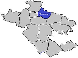
Nevasa taluka (Newasa), is a taluka in Shrirampur subdivision of Ahmednagar district in Maharashtra state of India. Nevasa is a place where Sant Dnyaneshwar wrote the Dnyaneshwari.

<span class="mw-page-title-main">Pathardi taluka</span> Tehsil in Maharashtra, India

Pathardi taluka is a taluka in Ahmednagar subdivision of Ahmednagar district in Maharashtra state of India.

<span class="mw-page-title-main">Rahata taluka</span> Tehsil in Maharashtra, India

Rahata taluka, is a taluka in Shrirampur subdivision of Ahmednagar district in Maharashtra State of India.

<span class="mw-page-title-main">Rahuri taluka</span> Tehsil in Maharashtra, India

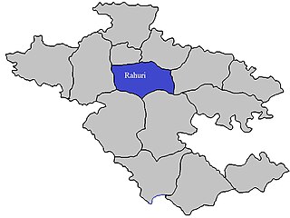
Rahuri taluka, is a taluka in the Shrirampur subdivision of the Ahmednagar district in Maharashtra, western India.

<span class="mw-page-title-main">Sangamner taluka</span> Tehsil in Maharashtra, India

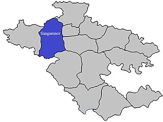
Sangamner taluka, is a taluka in Sangamner subdivision of Ahmednagar district in Maharashtra state of India.

<span class="mw-page-title-main">Shevgaon taluka</span> Tehsil in Maharashtra, India

Shevgaon taluka is a taluka in Ahmednagar subdivision of Ahmednagar district in Maharashtra state of India.

<span class="mw-page-title-main">Shrigonda taluka</span> Tehsil in Maharashtra, India

Shrigonda Taluka, is a taluka in Karjat subdivision of Ahmednagar District in Maharashtra state of India. Its administrative headquarters is the town of Shrigonda.

<span class="mw-page-title-main">Parner taluka</span> Tehsil in Maharashtra, India

Parner taluka is a taluka in Ahmednagar district in the state of Maharashtra in western India.

Ahmednagar district is a district in state of Maharashtra in India. There are 14 talukas (talukas) in Ahmednagar.

<span class="mw-page-title-main">Barshi taluka</span> Tehsil in Maharashtra, India

Barshi Taluka is one of the 11 talukas of Solapur District in the Indian state of Maharashtra. This tehsil occupies the Northeast corner of the district and is bordered by Osmanabad District to the north and east, Madha Taluka to the west, Mohol Taluka to the southwest and North Solapur Taluka to the south. The tehsil headquarters is located at Barshi, which is also the largest city in the tehsil.

<span class="mw-page-title-main">Karmala Taluka</span> Taluka in Maharashtra, India

Karmala Taluka is one of the 11 talukas of Solapur district in the Indian state of Maharashtra. Parts of the movie Sairat were shot in this taluka. Its headquarters are in the town of Karmala.

References

  1. Talukas in Ahmednagar district
  2. Talukas geographic information
  3. "Table C-01 Population by Religion: Maharashtra". censusindia.gov.in. Registrar General and Census Commissioner of India. 2011.
  4. "District Census Hand Book – Ahmednagar" (PDF). Census of India . Registrar General and Census Commissioner of India.
  5. 1 2 "Table C-16 Population by Mother Tongue: Maharashtra". censusindia.gov.in. Registrar General and Census Commissioner of India.
  6. Rainfall information of Ahemadnagar district