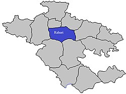
Rahuri taluka

Last updated

Rahuri
Rahuri Tehsil in Ahmednagar District.jpg
Location of Rahuri in Ahmednagar district in Maharashtra
CountryFlag of India.svg  India
State Maharashtra
District Ahmednagar district
Headquarters Shrirampur
Government
   Lok Sabha constituency ahmednagar south
   Assembly constituency rahuri
   MLA Prajakt Tanpure
Area
  Total1,035.11 km2 (399.66 sq mi)
Population
 (2011)
  Total322,823
  Density310/km2 (810/sq mi)
Demographics
   Literacy rate 73.78
Rain455 mm

Rahuri taluka, is a taluka in the Shrirampur subdivision of the Ahmednagar district in Maharashtra, western India. [1]

Contents

Area by land use [2]

Type of LandArea (km2) % of Total Area
Agriculture766.0974.01
Forest157.0615.17
Other111.9610.82
Total1035.11100

Rivers

The Mula River flows through Rahuri.

Villages

For a list of villages, see villages in Rahuri taluka .

There are at least 96 villages in Rahuri taluka.

Malharwadi is a village in Rahuri Taluka. It belongs to Nashik Division. It is located 38 km towards North from District headquarters Ahmednagar,10 km from Rahuri Khurd and 218 km from the state capital Mumbai.

Malharwadi Pin code is 413705 and postal head office is Rahuri Town .

Momin Akhada ( 3 km ), Digras ( 5 km ), Baragaon Nandur ( 5 km ), Birobanagar ( 6 km ), Rahuri Khurd ( 6 km ) are the nearby Villages to Malharwadi. Malharwadi is surrounded by Shrirampur Taluka towards North, Ahmednagar Taluka towards South, Rahata Taluka towards North, Nagar Taluka towards South

Ghorpadwadi is a village in Rahuri Taluka in Ahmednagar District of Maharashtra, India. It is in the region of Khandesh and Northern Maharashtra and is a part of the Nashik Division. It is located 39 km north of the district headquarters of Ahmednagar, 11 km from Rahuri Khurd and 217 km from Mumbai. Its exports include vegetables, such as onions and brinjal. Approximately 80% of the land is dedicated to agricultural purposes. Its major associating active group is |jai bajrang yuva pratisthan. |

Ghorpadwadi's Pin code is 413705 and the postal head office is at Rahuri town.

Nearby villages include Momin Akhada (3 km), Baragaon Nandur (4 km), Digras (6 km), Chinchvihire (7 km), Birobanagar (7 km), Vambori (19.5 km). Ghorpadwadi is surrounded by Shrirampur Taluka to the North, Ahmednagar Taluka and Nagar Taluka to the South and Rahata Taluka to the East.

Rahuri, Shrirampur, Ahmednagar, Sangamner, Belapur are nearby cities to Ghorpadwadi.

Ghorpadwadi 2011 Census Details

Ghorpadwadi's local language is Marathi. Its total population is 1509, and it has 259 houses. 48.2% of the population is female. The village's literacy rate is 63%, and the female literacy rate is 25.5%.

Vambori

Places to visit in Vambori are Dongargan, Bhairavji temple, gorakhksyanath temple, ostwal farmhouse.

Politics in Ghorpadwadi

The area's major political parties are BJP, NCP and SHS.

Polling Stations and Booths near Ghorpadwadi

  • Malewadi Dlukrewadi Z.p. School East West Building West Side Room No. 2
  • Ghatshiras Z.p. School East West Building West Side Room No. 1
  • Mokal Ohal Z.p. School East West Building West Side Room No. 2
  • Momin Akhada Z.p. School East West Building West Side Room No. 1
  • Vambori Mahesh Munot Vidyalaya South North (west Side Old Building ) South Side Room No. 3

Travel to Ghorpadwadi

By Road

Rahuri is the nearest town to Ghorpadwadi, 8 km (5 miles) away.

By Rail

Ghorpadwadi is also accessible by rail from Rahuri. The remaining 8 km (5 miles) to Ghorpadwadi must be traveled by road. Aurangabad, 103 km (64 miles) from Ghorpadwadi, is another rail link.

Colleges near Ghorpadwadi

Schools in Ghorpadwadi

Z.p.p.school Ghorpadwadi Address : ghorpadwadi , rahuri , ahmadnagar , Maharashtra . PIN- 413705 , Post - Rahuri Town

Population

Religions in Rahuri taluk (2011) [3]
ReligionPercent
Hinduism
91.64%
Islam
6.83%
Jainism
0.54%
Christianity
0.48%
Other or not stated
0.51%

Rahuri taluka has a population of 322,823 according to the 2011 census. Rahuri had a literacy rate of 79.74% and a sex ratio of 934 females per 1000 males. 69,810 (21.62%) live in urban areas. Scheduled Castes and Scheduled Tribes make up 13.51% and 10.54% of the population respectively. [4]

Languages of Rahuri taluk (2011) [5]

   Marathi (90.76%)
   Hindi (5.36%)
   Urdu (1.32%)
  Others (2.56%)

At the time of the 2011 Census of India, 90.76% of the population in the district spoke Marathi, 5.36% Hindi and 1.32% Urdu as their first language. [5]

Rainfall

The table below lists rainfall from 1981 to 2004. [6]

YearRainfall (mm)
1981639
1982434
1983665
1984427
1985301
1986242
1987533
1988725
1989524
1990788
1991466
1992407
1993548
1994455
1995642
1996555
1997345
1998585
1999581
2000587
2001358
2002302
2003299
2004509

Universities and colleges

See also

Related Research Articles

<span class="mw-page-title-main">Ahmednagar district</span> District in Maharashtra, India

Ahmednagar district is the largest district of Maharashtra state in western India. The historical Ahmednagar city is the headquarters of the district. Ahmednagar and Sangamner are the largest cities in the district. It was the seat of the Ahmednagar Sultanate of late medieval period. This district is known for the towns of Shirdi associated with Sai Baba, Meherabad associated with Meher Baba, Shani Shinganapur with Shanidev, and Devgad with Lord Dattatreya. Ahmednagar district is part of Nashik Division. The district is bordered by Aurangabad district to the northeast, Nashik district to the northwest, Thane and Pune districts to the southwest, Solapur district to the south and Beed district to the southeast.

<span class="mw-page-title-main">Rahata taluka</span> Tehsil in Maharashtra, India

Rahata taluka, is a taluka in Shrirampur subdivision of Ahmednagar district in Maharashtra State of India.

<span class="mw-page-title-main">Shrirampur taluka</span> Tehsil in Maharashtra, India

Shrirampur taluka, is a taluka in Shrirampur subdivision of Ahmednagar district in Maharashtra state of India.

<span class="mw-page-title-main">Parner taluka</span> Tehsil in Maharashtra, India

Parner taluka is a taluka in Ahmednagar district in the state of Maharashtra in western India.

Ahmednagar district is a district in state of Maharashtra in India. There are 14 talukas (talukas) in Ahmednagar.

Dadh Budruk is a village in Rahata taluka of the Ahmednagar district in Maharashtra, India. The village is known for its temples, particularly Sant Mukund Das Maharaj Samadhi Temple on the Pravara river, and Shiv Temple. The village is 28 km from Shirdi, a town known as the home of Shri Sai Baba.

Shingave is a village in Rahata taluka of Ahmednagar district in the Indian state of Maharashtra. It is one of the largest village by area in Rahata.

Ghorpadwadi is a village in Rahuri Taluka in Ahmednagar district of Maharashtra State, India. It belongs to Khandesh, the Northern Maharashtra region and the Nashik division. It is located 39 km towards North from District headquarters Ahmednagar. 11 km from Rahuri Khurd. 217 km from State capital Mumbai.

Wakadi is a village in Rahata taluka of Ahmednagar district in Indian state of Maharashtra. It has a temple dedicated to the Hindu deity Khandoba.It has a higher secondary school named 'shri Laxmi Narayan vidyalay' located in mid of town.

Chitali, is a village in Rahata taluka of Ahmednagar district in Indian state of Maharashtra.

Mamdapur is a village in Rahata taluka of Ahmednagar district in the Indian state of Maharashtra.

Rajuri is a village in Rahata taluka of Ahmednagar district in the Indian state of Maharashtra.

Ranjankhol is a village in Rahata taluka of Ahmednagar district in the Indian state of Maharashtra. It is located close to Shrirampur.

Pimpri Nirmal is a village in Rahata taluka of Ahmednagar district in the Indian state of Maharashtra. Literacy rate is almost 100 percent.

Gogalgaon is a village in Rahata taluka of Ahmednagar district in the Indian state of Maharashtra.

References

  1. Talukas in Ahmednagar district
  2. Talukas geographic information
  3. "Table C-01 Population by Religion: Maharashtra". censusindia.gov.in. Registrar General and Census Commissioner of India. 2011.
  4. "District Census Hand Book – Ahmednagar" (PDF). Census of India . Registrar General and Census Commissioner of India.
  5. 1 2 "Table C-16 Population by Mother Tongue: Maharashtra". censusindia.gov.in. Registrar General and Census Commissioner of India.
  6. Rainfall information of Ahemadnagar district