Kalsubai is a mountain in the Western Ghats, located in the Indian state of Maharashtra. Kalsubai is the highest peak in Maharashtra and is located in Ahmednagar district in Akole Taluka. Its summit, situated at an elevation of 1,646 metres (5,400 ft), is the highest point in Maharashtra and hence it is known as the "Everest of Maharashtra".

Narayangaon is a town in the Junnar taluka of the Pune district of Maharashtra state, India. Water is abundant because of its proximity to the major dams, the western ghats, and the Sahyadri mountain range.

Harishchandra Fort is a hill fort in the Ahilyanagar(Ahmednagar) district of India. Its history is linked with that of Malshej Ghat, Kothale village and it has played a role in guarding and controlling the surrounding region.

Amravati district is a district of Maharashtra state in central India. It is the administrative headquarter of Amravati division, which is one of the two divisions in Vidarbha, out of total 6 regions in state of Maharashtra.

Wai is a town in Satara district of Maharashtra state in India. Located on the Krishna River, Wai was a prominent town during the Peshwa era. Two important Marathi Brahmin from ruling families had their origins here: Rani Lakshmibai of Jhansi and Gopikabai, wife of Nanasaheb Peshwa.

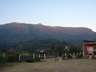
Bhandardara is a holiday resort village near Igatpuri, in the western ghats of India. The village is located in the Akole tehsil, Ahmednagar district of the state of Maharashtra, about 185 kilometers (115 mi) from Mumbai, 155 kilometers (96 mi) from Ahmednagar and 73 kilometers (45 mi) from Nashik.
Ahmednagar district, officially Ahilyanagar district, is the largest district of Maharashtra state in western India. The historical city of Ahmednagar is the headquarters of the district. Ahmednagar and Sangamner are the largest cities in the district. It was the seat of the Ahmednagar Sultanate of late medieval period. This district is known for the towns of Shirdi associated with Sai Baba, Meherabad associated with Meher Baba, Shani Shinganapur with Shanidev, and Devgad with Lord Dattatreya. Ahmednagar district is part of Nashik Division. The district is bordered by Aurangabad district to the northeast, Nashik district to the northwest, Thane and Pune districts to the southwest, Solapur district to the south and Beed district to the southeast.
Sillod is a city and a taluka in the Aurangabad district of the Indian state of Maharashtra. Sillod is represented in the Maharashtra Vidhan Sabha through the Sillod Vidhan Sabha constituency. MLA OF SILLOD IS Abdul sattar
Murbad is a census town within the administrative division (taluka) of Thane district in the Indian state of Maharashtra. Murbad city with its neighbouring villages jointly form the Murbad nagar panchayat, which is near the cities of Thane, Karjat and Kalyan. Nearby cities include Badlapur, Ambernath, Ulhasnagar, and Dombivli. It is a largely industrial town with private and public enterprises (MIDC).
Shirur is an administrative subdivision of the Pune district in the Indian state of Maharashtra. It is located on the eastern boundary of the district, on the banks of the Ghod River. The town is also called Ghodnadi to distinguish it from other locations that have the same name. Ghodnadi in Marathi Language means Ghod River.

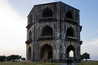
Ratangad is a fort in Ratanwadi, Maharashtra, India, overlooking the locale of Bhandardara, one of the oldest artificial catchment area. This fort is located in the Ahmadnagar district of Maharashtra. It is on the boundary of Ahmadnagar and Thane districts. The fort is about 400 years old. This fort is often covered with flowering plants in November. Ratangad is also called Jewel of the Sahyadris.

Akole taluka is a taluka in Ahmednagar district in Maharashtra state of India. Akole consists of many places like Harishchandragad, Kalsubai, Bhandardara (Wilson) Dam, Sandhan Valley, Vishramgad etc. which attract tourists. Akole is not only famous for its natural scenery but, many historical events are also associated with it. The Western Akole is a part of Sahyadri ranges which increase its important.

Parner taluka is a taluka in Ahmednagar district in the state of Maharashtra in western India.
Sherikasari is a newly separated small village from Alkuti village of Parner Taluka in Ahmednagar District of state of Maharashtra, India.
Bhairavgad fort is located in the Sahyadri mountains of the Indian state of Maharashtra. Multiple mountains are named Bhairavgad including one near the Karad-Chiplun area, one near Malshej Ghat and third in the Bhandardara region in the neighborhood of Ghanchakkar the third highest peak of Sahyadris.

Jivdhan is a hill fortress situated 1 km from modern town of Ghatghar in Junnar Taluka of Pune district in Maharashtra, India. The fort, which rises 1,145 meters above sea level, is located in the Sahyadri mountain range. The fort was looted and destroyed by the British upon siege between 1815 and 1818.
Kavathe is a village located in Shirur Taluka of the Pune district of Maharashtra state. The village adds the name of local hindu goddess 'Yemai' for distinguishing from other villages in Maharashtra with similar name. Kavathe is known for it historical link with Maratha Empire and because of various folk art & artiste associated with Tamasha, drama, Jagaran-Gondhal and Bharud. Poet Bashir Momin Kavathekar and Dholak performer Shri Gangaram Bua are the two prominent folk artiste who had brought laurels with their notable contribution to the Maharashtra's performing art, culture and traditional art form Tamasha. Vithabai Bhau Mang Narayangaonkar's grandfather Shri Narayan Khude who formed his own Tamasha Troupe was also from Kavathe Yamai.

The Pravara is the smallest of the major tributaries of Godavari river located in Maharashtra, India. Among the 7 major tributaries, it is the only tributary which originates in the Western Ghats akin to Godavari. Also, it is the only major tributary of Godavari to have both its source and confluence located within the same district - Ahmednagar.
Darna is a minor right-bank tributary of Godavari in the Nashik District, Maharashtra, India. Rising north of the Kalsubai range, it drains Igatpuri, Nashik and Niphad Talukas of Nashik District. The conjunction with Godavari is situated at Darnasangvi.
Vithe is a village in akole Tahshil of Ahmednagar district in Maharashtra state of India. Vithe is the village on the bank of Pravara river. Vithe is also rich with natural resources. The forest in village is very much famous for variety of wild life. Peacock, Tiger, Lizard, Monkey and many more type of animals and birds are main attraction of forests in Vithe. These forests is under control of Government of Maharashtra.
