Pravara River

Last updated

Pravara
Umbrella falls bhandardara.jpg
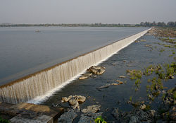
Umbrella falls on Pravara river
Location
Country India
State Maharashtra
District Ahmednagar
Cities Sangamner, Nevasa
Physical characteristics
Source Sahayadris
  location Ahmednagar, Nahik Subdivision, Maharashtra, India
  coordinates 19°31′45″N73°45′5″E / 19.52917°N 73.75139°E / 19.52917; 73.75139
  elevation750 m (2,460 ft)
Mouth Godavari River
  location
Pravara Sangam, Ahmednagar, Nahik Subdivision, Maharashtra, India
  coordinates
19°37′00″N75°01′00″E / 19.61667°N 75.01667°E / 19.61667; 75.01667
  elevation
531 m (1,742 ft)
Length208 km (129 mi)
Basin size6,537 km2 (2,524 sq mi)
Basin features
Tributaries 
  left Waki, Mahalungi
  right Mula

The Pravara is the smallest of the major tributaries of Godavari river located in Maharashtra, India. Among the 7 major tributaries, it is the only tributary which originates in the Western Ghats akin to Godavari. Also, it is the only major tributary of Godavari to have both its source and confluence located within the same district - Ahmednagar.

Contents

Etymology

As per Indian Vedas, [1] Sage Agastya meditated by consuming only water and air for a long tenure. Due to his incredible devotion, Lord Shiva appeared, blessed him, and left a stream of Ganga that came to be known as the Pravara River.

Origin

The Pravara rises on the eastern slopes of the Sahayadris between Kulang and Ratangad mountains in the Ahmednagar District of Maharashtra. [2]

Course

Close to its origin the river flows into the town of Bhandardara. Here, the Bhandardara Dam is constructed across the river forming the Arthur Lake. The gates of the dam are periodically opened, to allow drownstream flow of the Pravara, giving rise to the Umbrella Falls. From hereon the river takes an east ward course and 58 km downstream, reaches another city- Sangamner, where the river Mahalungi converges with it. This is the second largest city within the Ahmednagar District. Continuing eastwards, the river is joined by another tributary, this time on its right bank: River Mula. The river then, reaches the town of Nevasa and flows 12 km to the east where it finally empties itself into the Godavari River at Pravara Sangam [3] located 208 km (129 mi) from its source of origin.

Tributaries

In its short run, the river acquires water from two main tributaries : Mahalungi and Mula.

Dams

Related Research Articles

<span class="mw-page-title-main">Godavari River</span> River in India

The Godavari is India's second longest river after the Ganga river and drains into the third largest basin in India, covering about 10% of India's total geographical area. Its source is in Trimbakeshwar, Nashik, Maharashtra. It flows east for 1,465 kilometres (910 mi), draining the states of Maharashtra (48.6%), Telangana (18.8%), Andhra Pradesh (4.5%), Chhattisgarh (10.9%) and Odisha (5.7%). The river ultimately empties into the Bay of Bengal through an extensive network of distributaries. Measuring up to 312,812 km2 (120,777 sq mi), it forms one of the largest river basins in the Indian subcontinent, with only the Ganga and Indus rivers having a larger drainage basin. In terms of length, catchment area and discharge, the Godavari is the largest in peninsular India, and had been dubbed as the Dakshina Ganga.

<span class="mw-page-title-main">Kalsubai</span> Mountain in India

Kalsubai is a mountain in the Western Ghats, located in the Indian state of Maharashtra. Kalsubai is the highest peak in Maharashtra and is located in Ahmednagar district in Akole Taluka. Its summit, situated at an elevation of 1,646 metres (5,400 ft), is the highest point in Maharashtra. Hence, known as the Everest of Maharashtra.

<span class="mw-page-title-main">Bhima River</span> Major river in southwest India

The Bhima River is a major river in Western India and South India. It flows southeast for 861 kilometres (535 mi) through Maharashtra, Karnataka, and Telangana states, before entering the Krishna River. After the first sixty-five kilometers in a narrow valley through rugged terrain, the banks open up and form a fertile agricultural area which is densely populated.

<span class="mw-page-title-main">Bhandardara</span> Village in Maharashtra, India

Bhandardara is a holiday resort village near Igatpuri, in the western ghats of India. The village is located in the Akole tehsil, Ahmednagar district of the state of Maharashtra, about 185 kilometers (115 mi) from Mumbai and 155 kilometers (96 mi) from Ahmednagar.

<span class="mw-page-title-main">Ahmednagar district</span> District in Maharashtra, India

Ahmednagar district is the largest district of Maharashtra state in western India. The historical Ahmednagar city, is the headquarters of the district. Ahmednagar and Sangamner are largest cities in the district. It was the seat of the Ahmednagar Sultanate of late medieval period. This district is known for the towns of Shirdi associated with Sai Baba, Meherabad associated with Meher Baba, Shani Shinganapur with Shanidev, and Devgad with Lord Dattatreya. Ahmednagar district is part of Nashik Division. The district is bordered by Aurangabad district to the northeast, Nashik district to the northwest, Thane and Pune districts to the southwest, Solapur district to the south and Beed district to the southeast.

Akole is a city and Taluka in Akole tehsil, Ahmednagar district in the state of Maharashtra, India. Akole is surrounded by the Sahyadri Mountains of Western Ghats, India. Several historical sites in the city honor Akole's connection to the history and culture of Maharashtra.

<span class="mw-page-title-main">Nevasa</span> Town in Maharashtra, India

Nevasa is a city in Nevasa tehsil of Ahmednagar district in the Indian state of Maharashtra. Old names of this place are Nidhinivas, Nivas and Mahalaya Also town of lord Kuber. Sant Dnyaneshwar Temple is main temple. This place is near of Pravara river, this river is also called Amritvahini.

<span class="mw-page-title-main">Manjira River</span> Tributary of river Godavari

The Manjara River is a tributary of the river Godavari. It passes through the states of Maharashtra, Karnataka and Telangana. It originates in the Balaghat range of hills near the Ahmednagar district at an altitude of 823 metres (2,700 ft) and empties into the Godavari River. It has a total catchment area of 30,844 square kilometres (3,084,400 ha). This river is one of the Triveni Sangam.

<span class="mw-page-title-main">Painganga River</span>

The Painganga River is the chief river of the Buldhana district, Hingoli district, Nanded district, Yavatmal district, Chandrapur district and Washim district in the Maharashtra state in India. It flows along the southeast boundaries of the district in a winding, meandering course. It is deeply entrenched and difficult to navigate. It rises in the Ajantha range and is a major tributary of the Wardha River, the other major river in the district. It is also divided Marathwada and Vidarbha near Umarkhed and Himayatnagar.

Ahmednagar district is a district in state of Maharashtra in India. There are 14 talukas (talukas) in Ahmednagar.

Bhairavgad fort is located in the Sahyadri mountains of the Indian state of Maharashtra. Multiple mountains are named Bhairavgad including one near the Karad-Chiplun area, one near Malshej Ghat and third in the Bhandardara region in the neighborhood of Ghanchakkar the third highest peak of Sahyadris.

Shrirampur District is a proposed district in Maharashtra which is currently subdivision of Ahmednagar district.

<span class="mw-page-title-main">Sindphana River</span> River in Maharashtra, India

Sindphana is a minor tributary of Godavari river that originates around the Chincholi hill in Patoda Taluka, Beed District, Maharashtra, in India. Crossing west to east its drainage basin covers nearly 80% of Beed District, making it the most important river within the district. The Majalgaon Dam, constructed across the river, irrigates 93885 hectares of land in Beed, Parbhani & Nanded districts.

Darna is a minor left-bank tributary of Godavari in the Nashik District, Maharashtra. Rising north of the Kalsubai range, it drains Igatpuri, Nashik and Niphad Talukas of Nashik District. The conjunction with Godavari is situated at Darnasangvi.

Kadva river is a minor but important tributary of Godavari in Nashik district, Maharashtra. It originates and flows through the Dindori Taluka of Nashik District.

<span class="mw-page-title-main">Shivana River</span> River in Maharashtra, India

Shivana River is a minor but important tributary of Godavari lying entirely within Aurangabad district, Maharashtra. It rises in the Kannad taluka, from the south-western slope of the Ajanta Hills which also holds the origin to another major tributary Purna.

<span class="mw-page-title-main">Vithe</span> Village in Maharashtra

Vithe is a village in akole Tahshil of Ahmednagar district in Maharashtra state of India. Vithe is the village on the bank of Pravara river. Vithe is also rich with natural resources. The forest in village is very much famous for variety of wild life. Peacock, Tiger, Lizard, Monkey and many more type of animals and birds are main attraction of forests in Vithe. These forests is under control of Government of Maharashtra.

References

  1. "Did You Know - Anandvan Resort - Bhandardara".
  2. "Geography of Ahmednagar District" . Retrieved 10 April 2016.
  3. Cyrille Korsakoff, Tina Kuo Shi Wen. "PRAVARA SANGAM MAHARASHTRA INDIA Geography Population Map cities coordinates location - Tageo.com". www.tageo.com.