
Aurangabad, officially known as Chhatrapati Sambhaji Nagar, or Chhatrapati Sambhajinagar, is a city in the Indian state of Maharashtra. It is the administrative headquarters of Aurangabad district, Maharashtra and is the largest city in the Marathwada region. Located on a hilly upland terrain in the Deccan Traps, Aurangabad is the fifth-most populous urban area in Maharashtra after Mumbai, Pune, Nagpur and Nashik with a population of 1,175,116. The city is known as a major production center of cotton textile and artistic silk fabrics. Several prominent educational institutions, including Dr. Babasaheb Ambedkar Marathwada University, are located in the city. The city is also a popular tourism hub, with tourist destinations like the Ajanta and Ellora caves lying on its outskirts, both of which have been designated as UNESCO World Heritage Sites since 1983. Other tourist attractions include the Aurangabad Caves, Devagiri Fort, Grishneshwar Temple, Jama Mosque, Bibi Ka Maqbara, Himayat Bagh, Panchakki and Salim Ali Lake. Historically, there were 52 Gates in Aurangabad, some of them extant, because of which Aurangabad is nicknamed as the "City of Gates". In 2019, the Aurangabad Industrial City (AURIC) became the first greenfield industrial smart city of India under the country's flagship Smart Cities Mission.

The Massachusetts Water Resources Authority (MWRA) is a public authority in the Commonwealth of Massachusetts that provides wholesale drinking water and sewage services to 3.1 million people in sixty-one municipalities and more than 5,500 large industrial users in the eastern and central parts of the state, primarily in the Boston area.

The Washington Aqueduct is an aqueduct that provides the public water supply system serving Washington, D.C., and parts of its suburbs, using water from the Potomac River. One of the first major aqueduct projects in the United States, it was commissioned by the U.S. Congress in 1852, and construction began in 1853 under the supervision of Montgomery C. Meigs and the U.S. Army Corps of Engineers. Portions of the aqueduct went online on January 3, 1859, and the full pipeline began operating in 1864.
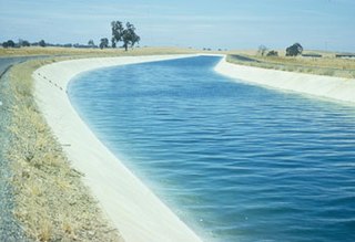
The Delta–Mendota Canal is a 117-mile-long (188 km) aqueduct in central California, United States. The canal was designed and completed in 1951 by the U.S. Bureau of Reclamation as part of the Central Valley Project. It carries freshwater to replace San Joaquin River water which is diverted into the Madera Canal and Friant-Kern Canal at Friant Dam.
Mt Evelyn Aqueduct was a former feature of the Melbourne water supply infrastructure that was built by the Melbourne and Metropolitan Board of Works The O'Shannassy Water Supply. Where the aqueduct crossed the lower lying areas around Wandin and approaching Mount Evelyn, it was in steel or wood-stave piping, converting to open concrete-lined channel when the higher levels were reached. It went through the township of Mount Evelyn in open channel winding around the local contours to just above what is now Johns Crescent, then part of the 'Pine Mont Estate.'

Malik Ambar was a military leader and statesman who served as the Peshwa of the Ahmadnagar Sultanate and its de facto ruler from 1600 until his death in 1626.

Khuldabad is a city and a Taluka of Aurangabad district in the Indian state of Maharashtra. It is known as the Valley of Saints, or the Abode of Eternity, because in the 14th century, several Sufi saints chose to reside here. The Bhadra Maruti Temple and Dargah of Zar Zari Zar Baksh, Shaikh Burhan ud-din Gharib Chisti and Shaikh Zain-ud-din Shirazi, along with the tomb of the Mughal emperor Aurangzeb and his trusted General Asif Jah I, the first Nizam of Hyderabad, are located in this town. It is a holy and spiritual city of Islamic saints.

The Prospect Reservoir is a heritage-listed 50,200-megalitre potable water supply and storage reservoir created by the Prospect Dam, across the Prospect Creek located in the Western Sydney suburb of Prospect, in New South Wales, Australia. The eastern bounds of the reservoir are a recreational area and the western periphery are within the bounds of Western Sydney Parklands. It was added to the New South Wales State Heritage Register on 18 November 1999.

Panchakki, a water mill, is located in Aurangabad, Maharashtra, displays the scientific thought process put in medieval Indian architecture. It was designed to generate energy via water brought down from a spring on a mountain. The building, attached to the dargah of Baba Shah Musafir, a Sufi saint, is located in a garden near the Mahmud Darvaza and consist of a mosque, a madrassa, a kacheri, a minister's house, a sarai and houses for zananas.

The Framingham Reservoir No. 1 Dam and Gatehouse is a historic water works facility in Framingham, Massachusetts. This complex is located at the end of Framingham Reservoir No. 1, which is also known as the Stearns Reservoir, off Winter Street and north of Long Avenue. Constructed from 1876 to 1878 as part of an expansion of the water supply of the city of Boston, this was designed by its first city architect George A. Clough. The historical purpose of the reservoir, which was located at the confluence of two branches of the Sudbury River, was primarily to control the river's water level, and secondarily to provide reserve supply capacity. The reservoir's reserve capacity was generally used only as a backup supply, as the reservoir's muddy bottom made it a less desirable source than reservoir No. 3 upstream. However the reservoir No. 1 system was nonetheless important due to its role in controlling the flow of the river downstream, and due to the gatehouse which controlled the water flows for all the Framingham reservoirs into the Sudbury Aqueduct. Reservoir No. 1 is no longer maintained as a reserve water source, although it is still owned by the Massachusetts Water Resources Authority, successor to the Boston Water Board which oversaw its construction. MWRA retains ownership as the gatehouse contains the connection between Reservoir No. 3 and the Sudbury Aqueudct which remain part of the emergency water systems.

The Sultanate of Ahmednagar or the Nizam Shahi Sultanate was a late medieval Indian Muslim kingdom located in the northwestern Deccan, between the sultanates of Gujarat and Bijapur, ruled by the Nizam Shahi or Bahri dynasty. It was established when Malik Ahmed, the Bahmani governor of Junnar after defeating the Bahmani army led by general Jahangir Khan on 28 May 1490 declared independence and established the Nizam Shahi dynasty of the Sultanate of Ahmednagar.
The San Diego Aqueduct, or San Diego Project, is a system of four aqueducts in the U.S. state of California, supplying about 70 percent of the water supply for the city of San Diego. The system comprises the First and Second San Diego Aqueducts, carrying water from the Colorado River west to reservoirs on the outskirts of San Diego. The 70-mile (110 km) First Aqueduct consists of pipelines 1 and 2, which run from the Colorado River Aqueduct near San Jacinto, California, to the San Vicente Reservoir, approximately 15 miles (24 km) northeast of the city. Pipelines 3 and 4 make up the 94-mile (151 km) Second Aqueduct. Together, these four pipelines have a capacity of 826 cubic feet per second (23.4 m3/s). The smaller, 12.5-mile (20.1 km) Fallbrook-Ocean Branch branches from the First Aqueduct into Murray Reservoir. The La Mesa-Sweetwater Branch originates from the First Aqueduct, flowing into the Sweetwater Reservoir.
Aurangabad is a medieval Indian town named after Mughal Emperor Aurangzeb, who established this town during his tenure as the Viceroy of the Deccan (Dakhin), a geographical region comprising parts of modern-day Maharashtra, Telangana and Karnataka.

Salim Ali Lake is located near Delhi Gate, one of the many Gates in Aurangabad, opposite Himayat Bagh, Aurangabad. It is located in the northern part of the city. During the Mughal period, it was known as Khiziri Talab. It has been renamed after the great ornithologist, naturalist Salim Ali and also known as birdman of India. The office of Divisional Commissioner Aurangabad division is located near it, so is the collector's office of Aurangabad District.
Himayat Bagh Biodiversity Heritage site is a 17th-century garden that now houses the Fruit Research Station and Nursery, which is a part of the Vasantrao Naik Marathwada Krishi Vidyapeeth. It is located near Delhi Gate in Rauza Bagh area of Aurangabad, in the Indian state of Maharashtra. It is a sprawling complex spread over 300 acres (1.2 km2), naturally green and in the olden days it was known as the Mughal Garden.
The Jama Masjid is a mosque built in 1612 AD, located near the Killa Arrak in Aurangabad, Maharashtra, India. It is historically significant because it was constructed in 1612 AD, very soon after the foundation of Aurangabad by Malik Amber in 1610 AD. The mosque was later extended by Aurangzeb(R.H) in the year 1692 AD, it is one of the oldest mosques of Aurangabad which is still in good condition.

The Nidd Aqueduct is an aqueduct or man-made watercourse in North Yorkshire, England. It feeds water from Angram and Scar House reservoirs in upper Nidderdale, North Yorkshire 32 mi (51 km) to Bradford in West Yorkshire. The aqueduct supplies 21,000,000 imp gal (95,000 m3) of water per day to Chellow Heights water treatment works. The aqueduct and the reservoirs it connects to are all maintained by Yorkshire Water.

The Guildford West pipehead and water supply canal is a heritage-listed sewerage infrastructure and water supply canal located at Frank Street, Guildford in the Cumberland Council local government area of New South Wales, Australia. It is also known as Headworks; Industrial Archaeological Site. The property is owned by Sydney Water, an agency of the Government of New South Wales. It was added to the New South Wales State Heritage Register on 15 November 2002.

The Murdock Canal, also known as the Provo Reservoir Canal and the Provo River Aqueduct, is a 23 mile water conveyance system that diverts water from the Provo River and other water storage systems to water users in Utah County. The canal starts at the Murdock Diversion Dam which is located at the mouth of Provo Canyon in Provo, Utah. The canal runs completely underground through Utah Valley and ends at the Jordan Aqueduct in Lehi, Utah. It carries water through the cities of Orem, Lindon, Pleasant Grove, Cedar Hills, American Fork, Highland, and Lehi. The canal is the largest of three primary water conveyance systems in Salt Lake Valley, the other systems being the Jordan Aqueduct and the Salt Lake Aqueduct. The water capacity of the Murdock Canal more than doubles that of either the Jordan Aqueduct or Salt Lake Aqueduct at 612 cfs.


