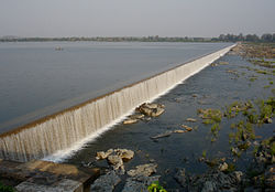
Pench River

Last updated

Pench River
Pench river before Chhindwara.jpg
Pench river before Chhindwara
Pench River
Location
Country India
Cities Junnardeo, Parasia, Chhindwara, Chourai, Kamthi
Physical characteristics
Source Satpura range
  location Junnardeo, Chhindwara District, Madhya Pradesh
  coordinates 22°18′N78°35′E / 22.300°N 78.583°E / 22.300; 78.583
  elevation1,048 m (3,438 ft)
Mouth Kanhan River
  location
Kamthi, Nagpur District, Nagpur
  coordinates
21°16′N79°10′E / 21.267°N 79.167°E / 21.267; 79.167
  elevation
310 m (1,020 ft)
Basin features
Tributaries 
  right Kulbehra River

The Pench River is an Indian tributary of the Kanhan River. It originates in the Chhindwara district of Madhya Pradesh and flows across Pench National Park, which is a reserve for the Tiger Project of India.

Contents

The two big dams of the Pench River supply water to the city of Nagpur and to the big thermal power plant located there. Machagora Pench dam supply the water to Seoni district and Chhindwara district for agriculture through irrigation canels.

Pench National Park

The river separates Pench National Park into two halves, east and west Pench. The Pench Tiger Reserve derives its name after the Pench River, which flows from north to south across the reserve. The reserve is situated on the south of the Satpura Hill Ranges in the Seoni District and Chhindwara District in the Madhya Pradesh state of India. The topography is undulating, with most of the area enclosed by small hill ranges and abrupt slopes on all the sides. The Pench river flowing through the centre of the Reserve is usually dry by April, but a number of water pools, locally known as dohs, are found along the course of the river. These serve as waterholes for wild animals. A few perennial springs also exist in the region. Recently, a number of earthen ponds and shallow wells have been created, providing well-distributed sources of water across the reserve.

Dam

The hydroelectric Totladoh Dam on the Pench River was the first interstate project of Maharashtra. It is located in the Pench National Park. The next big dam is Kamthikhairy Dam near just downstream of the Totladoh Dam the town of Navegaon Khairy located in Parseoni Taluka. More than 70% of the drinking water in Nagpur is supplied from the dams.

The Pench right canal is made up of combination of concrete lining and Bituminous geomembrane lining in select areas to limit seepage. [1] It supplies water to Nagpur, the Koradi Thermal Power Station, and the Khaparkheda Thermal Power Station, and the rest of the water is use for irrigation in Parseoni taluka, Kalmeshwar taluka, Saoner taluka, Kamthi taluka, and rural Nagpur. [2] The Pench left canal irrigates Parseoni taluka, Ramtek taluka, and Mauda taluka and provides water for the NTPC Mauda Super Thermal Power Station and other industrial purposes.

Related Research Articles

<span class="mw-page-title-main">Satpura Range</span> Hill range in central India

The Satpura Range is a range of hills in central India. The range rises in eastern Gujarat running east through the border of Maharashtra and Madhya Pradesh and ends in Chhattisgarh. The range parallels the Vindhya Range to the north, and these two east–west ranges divide Indian Subcontinent into the Indo-Gangetic plain of northern India and the Deccan Plateau of the south. The Narmada River originates from north-eastern end of Satpura in Amarkantak, and runs in the depression between the Satpura and Vindhya ranges, draining the northern slope of the Satpura range, running west towards the Arabian Sea. The Tapti River originates in the eastern-central part of Satpura, crossing the range in the center and running west at the range's southern slopes before meeting the Arabian Sea at Surat, draining the central and southern slopes of the range. Multai, the place of Tapti river origin is located about 465 kilometer far, south-westerly to Amarkantak, separated across by the hill range. The Godavari River and its tributaries drain the Deccan plateau, which lies south of the range, and the Mahanadi River drains the easternmost portion of the range. The Godavari and Mahanadi rivers flow into the Bay of Bengal. At its eastern end, the Satpura range meets the hills of the Chotanagpur Plateau. The Satpura Range is a horst mountain and is flanked by Narmada Graben in the north and much smaller but parallel Tapi Graben in the south.

<span class="mw-page-title-main">Chhindwara</span> City in Madhya Pradesh, India

Chhindwara is a village in India and a Municipal Corporation in the Chhindwara district in the Indian state of Madhya Pradesh. The city is the administrative headquarters of Chhindwara District. Chhindwara is reachable by rail or road from adjacent cities Betul, Jabalpur and Nagpur. The nearest airports are in Nagpur,Mumbai,New Delhi and Srinagar (130 km); however there is a small airport located in the village

  1. which is not serviceable for passenger planes.
<span class="mw-page-title-main">Wainganga River</span> Major River in Central India, India

The Wainganga is a river in India originating in the Mahadeo Hills in Mundara in Gondwana region near the village Gopalganj in Seoni, Madhya Pradesh. It is a key tributary of the Godavari. The river flows south in a winding course through the states of Madhya Pradesh and Maharashtra, roughly 580 km (360 mi). After joining the Wardha River, the united stream, which is known as the Pranahita River, empties into the Godavari River at Kaleshwaram, Telangana.

<span class="mw-page-title-main">Godavari River Basin Irrigation Projects</span>

The Godavari River has its catchment area in seven states of India: Maharashtra, Telangana, Chhattisgarh, Madhya Pradesh, Andhra Pradesh, Karnataka and Odisha. The number of dams constructed in Godavari basin is the highest among all the river basins in India. Nearly 350 major and medium dams and barrages had been constructed in the river basin by the year 2012.

<span class="mw-page-title-main">Chhindwara district</span> District of Madhya Pradesh, India

Chhindwara district is one of the major districts of Madhya Pradesh state of India, and Chhindwara town is the district headquarters. Chhindwara was the largest district in Madhya Pradesh with an area of 10,293 square km before the bifurcation of Pandhurna district. The district is part of Jabalpur division.

<span class="mw-page-title-main">Seoni district</span> District of Madhya Pradesh in India

Seoni District is a district of Madhya Pradesh state in central India. The town of Seoni is the district headquarters.

<span class="mw-page-title-main">Seoni, Madhya Pradesh</span> City in Madhya Pradesh, India

Seoni is a city and a municipality in Seoni district in the Indian state of Madhya Pradesh. This tribal household dominated district was formed in the year 1956.

Damua is a census town in Chhindwara district in the state of Madhya Pradesh, India.

<span class="mw-page-title-main">Nainpur</span> Municipality in Madhya Pradesh, India

Nainpur is a town and Municipal City in the Mandla district of the Indian state of Madhya Pradesh.

<span class="mw-page-title-main">Sarni, India</span> Town in Madhya Pradesh, India

Sarni is a town located in the Betul District of Madhya Pradesh. It is administered by the Municipal Council of Sarni, which oversees the four contiguous settlements of Sarni, Pathakhera, Shobhapur Colony and Bagdona.

<span class="mw-page-title-main">Parseoni</span> Town in Maharashtra, India

Parseoni is a town and a tehsil in Ramtek subdivision of Nagpur district in Nagpur revenue Division in the Berar region in the state of Maharashtra, India.

<span class="mw-page-title-main">Pench Tiger Reserve</span> Tiger Reserve in Central India

Pench Tiger Reserve or Pench National Park is one of the premier tiger reserves of India and the first one to straddle across two states - Madhya Pradesh and Maharashtra. The reference to Pench is mostly to the tiger reserve in Madhya Pradesh.

Barkuhi is a small township in Chhindwara District in the Indian state of Madhya Pradesh.

<span class="mw-page-title-main">Totladoh Dam</span> Dam in Ramtek

Totladoh dam, is a gravity dam on the Pench river near Ramtek in Nagpur district in the state of Maharashtra and adjoining Madhya Pradesh in India.

Pathakhera is a town in the municipal council of Sarni in the Betul District, Madhya Pradesh, India. The town is also known as Coal Nagari and also locally as NCDC, an acronym for National Coal Development Corporation.

<span class="mw-page-title-main">Narmada Valley Development Authority</span> Indian government organization

Narmada Valley Development Authority (NVDA) concerns Narmada River, the river of Madhya Pradesh. With 87% of its catchment area lying in Madhya Pradesh, it becomes all the more important for the state to exploit this enormous water resource. It was with this motto in mind that the Narmada Valley Development Authority (NVDA) was formed by the government of MP on 9 August 1985. NVDA oversees all major development projects in the Narmada Basin. The body also ensures that proper rehabilitation is provided to the displaced, and the negative impacts on environment are minimized by taking appropriate measures.

Pench National Park is a national park in the Indian state of Madhya Pradesh and was established in 1975 with an area of 257.26 km2 (99.33 sq mi). It is part of Pench Tiger Reserve and derives its name from the Pench River that flows through the park from north to south dividing the park into almost equal western and eastern halves, the well-forested areas of Seoni and Chhindwara districts respectively. It was declared a sanctuary in 1965, raised to the status of national park in 1975 and enlisted as a tiger reserve in 1992.

<span class="mw-page-title-main">Narkhed taluka</span> Tehsil in Maharashtra, India

Narkhed taluka is one of the 14 taluka of Nagpur district in state of Maharashtra, India.

<span class="mw-page-title-main">Kanhan River</span> River in Maharashtra, India

The Kanhan River is an important right bank tributary of the Wainganga River draining a large area lying south of Satpura range in central India. Along its 275 km run through the Indian States of Maharashtra and Madhya Pradesh, it receives its largest tributary - Pench River, a major water source for the metropolis of Nagpur.

<span class="mw-page-title-main">2020 Vidarbha floods</span>

The 2020 Vidarbha Floods were a series of flooding events that occurred in the Vidarbha region of Indian State of Maharashtra in 2020. The floods affected the districts of Nagpur, Bhandara, Chandrapur, Gadchiroli and Gondia. Over 92,000 people were affected in the region.

References

  1. Llinas, Pau; Breul, Bertrand (2023). Bituminous Geomembrane (BGM) in hot climates for hydraulic construction. 4th African Regional Conference on Geosynthetics (GeoAfrica 2023). Art. 02011. doi:10.1051/e3sconf/202336802011 . Retrieved 18 April 2024.
  2. "Nagpur Rivers" . Retrieved 26 November 2014.