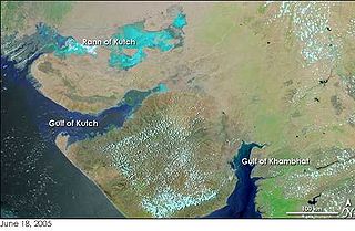
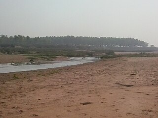
The Great Rann of Kutch is a salt marsh in the Thar Desert in the Kutch District of Gujarat, India. It is about 7500 km2 in area and is reputed to be one of the largest salt deserts in the world. This area has been inhabited by the Kutchi people.

Salsette Island is an island in Konkan division of the state of Maharashtra on India's west coast. Administratively known as the Greater Mumbai, the city district of Mumbai, Mumbai Suburban District, Mira Bhayander and a portion of Thane lie within it, making it very populous and one of the most densely populated islands in the world. It has a population of more 20 million inhabitants living on an area of about 619 square kilometres (239 sq mi).
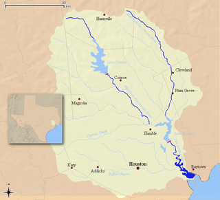
The San Jacinto River flows through southeast Texas. It is named after Saint Hyacinth. In the past, it was home to the Karankawa and Akokisa tribes.
The 2005 Maharashtra floods impacted many parts of the Indian state of Maharashtra including large areas of the metropolis Mumbai, a city located on the coast of the Arabian Sea, on the Western coast of India, in which approximately 1,094 people died. It occurred just one month after the June 2005 Gujarat floods. The term 26 July, is used to refer to the day when the city of Mumbai came to a standstill due to flooding.

The Mithi River is a river on Salsette Island, the island of the city of Mumbai, India. It is a confluence of tail-water discharges of the Powai and Vihar lakes. The river is seasonal and rises during the monsoons. The overflowing lakes also contribute to the river flow, which is stopped by a dam at other times. During this season, the gutter is a favourite with anglers, who can catch large fish that have escaped from the lakes. Chattrapati Shivaji Maharaj International Airport is located right next to the section of river at Andheri (E).

The MeenachilRiver or Meenachilaar, also known as Kavanar, Valanjar, is a river in Kerala. It is one of the most treacherous rivers in Kerala due to its flash floods, heavy undercurrents and woods and debris it carries from the mountains. It flows through the heart of Kottayam district, Kerala state in southern India. 78km long, originates in the Western Ghats main tributaries are Theekoy aaru from Vagamon hills, Poonjar Aaru and Chittar, flowing westward through the city of Kottayam and other towns like Poonjar, Teekoy, Erattupetta, Bharananganam, Pala, Mutholy, Cherpunkal, Kidangoor and Kumarakom before emptying into the Vembanad Lake on the shore of the Indian Ocean.

Nagarjuna Sagar Dam is a masonry dam across the Krishna River at Nagarjuna Sagar which straddles the border between Nalgonda district in Telangana and Palnadu district in Andhra Pradesh. The dam provides irrigation water to the Nalgonda, Suryapet, Krishna, NTR, Bapatla, Eluru, Palnadu, Khammam, West Godavari, Guntur, and Prakasam districts along with electricity generation.

Oshiwara River is a river in Mumbai, India. It begins in the Aarey Milk Colony, cuts through the Goregaon hills, across the Aarey Milk Colony before emptying into the Malad Creek. On the way it is joined by another creek near Swami Vivekanand Road, before picking up industrial effluents and sewage while crossing the Oshiwara industrial estates and slums of Andheri. Most of the call centres in Malad have been built on reclaimed ground at the mouth of the river.

Dahisar River is a river on Salsette island that runs through Dahisar, a suburb of Mumbai, India. It originates in the Tulsi Lake in Sanjay Gandhi National Park in the northern reaches of the city. The River flows roughly North-West for a total of 12 kilometres through the localities of the National Park, Sri Krishna Nagar, Daulatnagar, Leprosy Colony, Kandar Pada, Sanjay Nagar, and Dahisar Gaothan before meeting the Arabian sea via the Manori Creek. Its total Catchment area is 3488 hectares.
Farakka Barrage is a barrage across the Ganga river located in Murshidabad district in the Indian state of West Bengal, roughly 18 kilometres (11 mi) from the border with Bangladesh near Shibganj. Farakka Barrage Township is located in Farakka in Murshidabad district. Construction of the Farakka barrage started in 1962, was completed in 1970 at a cost of $208 million. Operations began on 21 April 1975. The barrage is about 2,304 metres (7,559 ft) long. The Feeder Canal (Farakka) from the barrage to the Bhagirathi-Hooghly River is about 42 km (26 mi) long.
Gavin Ferreira is a former international field hockey player who resides in Orlem, Malad. He is an alumnus of St Anne's High School, Orlem and St Xavier's College, Mumbai.

Kandivali formerly Khandolee is a neighbourhood in the north of Mumbai, Maharashtra, India and has a large Gujarati and Koli population. The area also has huge amount of labour North Indian population coming from UP and Bihar region.
The 2008 Indian floods were a series of floods in various states of India during the 2008 monsoon season. The floods mostly affected the western regions of Maharashtra state and Andhra Pradesh as well as northern Bihar. In India, the monsoon season generally lasts from June to September.
Bihar is India's most flood-prone state, with 76% of population in the North Bihar living under the recurring threat of flood devastation. Bihar makes up 16.5% of India's flood affected area and 22.1% of India's flood affected population. About 73.06% of Bihar's geographical area, i.e. 68,800 square kilometres (26,600 sq mi) out of 94,160 square kilometres (36,360 sq mi), is flood affected. On an annual basis, they destroy thousands of human lives apart from livestock and assets worth millions. In total, they have claimed 9,500 lives since the government started publishing figures in 1979. North Bihar districts are vulnerable to at least five major flood-causing rivers during monsoon – Mahananda River, Koshi River, Bagmati River, Burhi Gandak River and Gandak – which originate in Nepal. Some south Bihar districts have also become vulnerable to floods from Son, Punpun and Phalgu rivers. The 2013 flood affected over 5.9 million people in 3,768 villages in 20 districts of the state. 2017 flood affected 19 districts of North Bihar killing 514 people and affecting 1.71 crore people.
The Hinglo River is a tributary of the Ajay River in the Indian states of Jharkhand and West Bengal.

The Bansloi River is a tributary of the Bhagirathi.

Water pollution is a major environmental issue in India. The largest source of water pollution in India is untreated sewage. Other sources of pollution include agricultural runoff and unregulated small-scale industry. Most rivers, lakes and surface water in India are polluted due to industries, untreated sewage and solid wastes. Although the average annual precipitation in India is about 4000 billion cubic metres, only about 1122 billion cubic metres of water resources are available for utilization due to lack of infrastructure. Much of this water is unsafe, because pollution degrades water quality. Water pollution severely limits the amount of water available to Indian consumers, its industry and its agriculture.
In June 2013, a mid-day cloudburst centered on the North Indian state of Uttarakhand caused devastating floods and landslides, becoming the country's worst natural disaster since the 2004 tsunami. The rainfall received that month was far greater than the rainfall the state usually received. Debris blocked the rivers, causing major overflow. The main day of the flood was 16 June 2013.
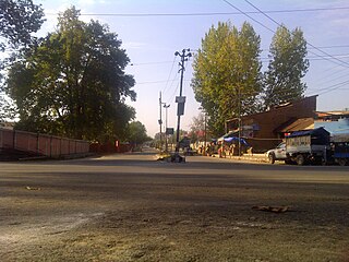
Rajbagh is the notified area in the municipal committee of Srinagar, in the Indian union territory of Jammu and Kashmir. It comes under the Amira Kadal Constituency. Rajbagh is a posh locality in the civil line area of Srinagar. The postal code of Rajbagh is 190008. Rajbagh is considered one of the many best residential places in Srinagar. There are many hotels, restaurants and schools in this locality. Rajbagh area was heavily damaged by the 2014 Kashmir floods, it was one of the worst affected areas due to flood.
Jawahar Nagar is the notified area in the municipal committee of Srinagar, in the Indian administered union territory of Jammu and Kashmir. It comes under the Amira Kadal Constituency. Jawahar Nagar is a posh locality in the civil line area of Srinagar. The postal code of Jawahar Nagar is 190008. Jawahar Nagar is considered one of the many best residential places in Srinagar. The airport is located at a distance of 9.3 km (5.8 mi). Jawahar Nagar area was heavily damaged by the 2014 Kashmir floods, it was one of the worst affected areas due to flood. There are two Branches of Jammu and Kashmir Bank, one of which is exclusively for women. There are multiple gymnasiums, mosques and shops in the area.
