
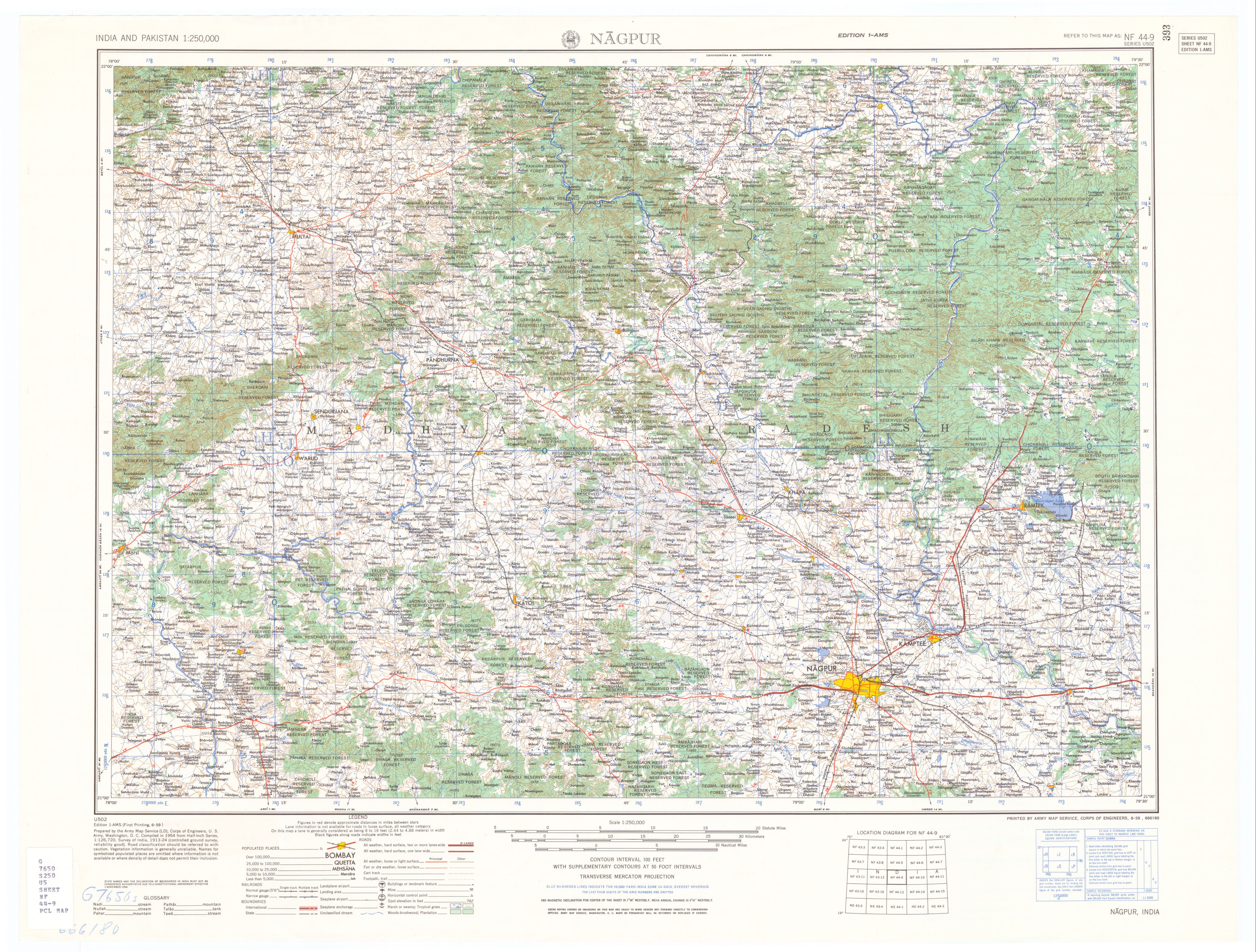
The Wainganga is a river in India originating in the Mahadeo Hills in Mundara in Gondwana region near the village Gopalganj in Seoni, Madhya Pradesh. It is a key tributary of the Godavari. The river flows south in a winding course through the states of Madhya Pradesh and Maharashtra, roughly 580 km (360 mi). After joining the Wardha River, the united stream, which is known as the Pranahita River, empties into the Godavari River at Kaleshwaram, Telangana.

Amravati district is a district of Maharashtra state in central India. It is the administrative headquarter of Amravati division, which is one of the two divisions in Vidarbha, out of total 6 regions in state of Maharashtra.

The Bhima River is a major river in Western and South India. It flows southeast for 861 kilometres (535 mi) through Maharashtra, Karnataka, and Telangana states, before joining the Krishna River. After the first sixty-five kilometers in a narrow valley through rugged terrain, the banks open up and form a fertile agricultural area which is densely populated.

Kamptee is a suburb of Nagpur city and a municipal council in Nagpur district in the Indian state of Maharashtra. It is part of the Nagpur metropolitan region development authority. It is the administrative center for Kamptee taluka. It is below the confluence of the Kanhan River with the rivers Pench and Kolar.

Chhindwara district is one of the major districts of Madhya Pradesh state of India, and Chhindwara town is the district headquarters. Chhindwara was the largest district in Madhya Pradesh with an area of 10,293 square km before the bifurcation of Pandhurna district. The district is part of Jabalpur division.
Kanhan (Pipri) is a census town in Nagpur district in the Indian state of Maharashtra.
Khapa is a city and a municipal council in Nagpur district in the Indian state of Maharashtra.

Kinwat is a city which falls under the municipal council of the Nanded District, in the Indian state of Maharashtra. The Kinwat Taluka came into existence in 1905 when a number of villages from Narsapur,Tamsi, and Nirmal Talukas from the Adilabad District, were combined. Earlier, these villages were under the Hyderabad Division. In 2011, Kinwat had population of 28454 with literacy rate of 82% and female sex ratio of 929. Kinwat is 125 km away from Nanded city. Kinwat has Rural Hospital.

Mohpa is a city with a municipal council in Nagpur district in the Indian state of Maharashtra. Although physically located within Kalmeshwar taluka, it is not subject to taluka governance. It is divided in to basically three part
Narkhed is a town and a municipal council in Nagpur district in the Indian state of Maharashtra. It is about 87 km north-west of Nagpur. It is the administrative headquarters of Narkhed taluka, one of the 14 talukas of this district. It is located in the "orange belt" and is a major center for orange-trading.
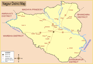
Saoner is a city and tehsil headquarters in north part of Nagpur district in state of Maharashtra, India. The town is governed by Savner municipal council. It is 36 kilometres (22 mi) from Nagpur city. Saoner is located on the bank of Kolar River. It is historically and mythologically important. Saoner has been backward city from state of Maharastra. Not being developed and lack of basic amenities for Saonerias like Vegetable and Non vegetable Markets, Medical, Educational and Sport activities all backward not good infrastructure to live people. Even Saonerians education rates is 45% along the country of India. Saoner tahsil people depend occupation on Farming. The peoples living there poverty line and standard of living cost among state of Maharastra very low.
Arvi is a city and municipal council in Wardha district in the state of Maharashtra, India.

The Nag River is a river flowing through the city of Nagpur in Maharashtra, India. It is known for providing the etymology for the name Nagpur.
Patansavangi is a panchayat village in Maharashtra State, India. Administratively, Patansavangi is under the Saoner Taluk of Nagpur District in Maharashtra, although earlier (1908) it had been part of the larger Ramtek taluka. It lies on the left (east) bank of the Kolar River, just upstream from its confluence with the Chandrabhaga Nadi. Patansavangi is 13 km by road southeast of the town of Saoner (Savner) and 25 km by road northwest of the town of Nagpur.
Narkhed taluka is one of the 14 taluka of Nagpur district in state of Maharashtra, India.

The Pench River is an Indian tributary of the Kanhan River. It originates in the Chhindwara district of Madhya Pradesh and flows across Pench National Park, which is a reserve for the Tiger Project of India.

The Kanhan River is an important right bank tributary of the Wainganga River draining a large area lying south of Satpura range in central India. Along its 275 km run through the Indian States of Maharashtra and Madhya Pradesh, it receives its largest tributary - Pench River, a major water source for the metropolis of Nagpur.

Nagpur South is one of the 288 Vidhan Sabha constituencies of Maharashtra state, western India. It is one of the six assembly seats which make up Nagpur Lok Sabha constituency. The Constituency Number is 53. This constituency is located in Nagpur district. The boundaries of the constituency were changed by the 2008 delimitation. It comprises parts of Nagpur Taluka, and Ward No. 9 to 11, 37 to 42, 73 to 78, 99 to 102 and 120 of Nagpur Municipal Corporation.

Jam is a river in central India originating in the Betul District of Madhya Pradesh.It flows through several villages and towns during its short run, ultimately draining itself off in Kanhan River. This confluence is located at the border with Maharashtra. An ambitious water project in the form of a dam has been proposed by Maharashtra in anticipation of the growing water needs of metro Nagpur. However the project has been shelved for now due to lack of co-operation from the state government in Madhya Pradesh.A gotmar fair is also organized every year on its bank.
Ambhora is a village situated in the Kuhi taluka of Nagpur district in the Indian state of Maharashtra. As of the 2011 Indian census, it had a population of 530.


