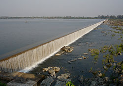
Taliperu River

Last updated

Taliperu is a river in the Godavari system originating in the Bijapur District of Chhattisgarh. It is a left-bank tributary of Godavari River, draining into it through a confluence located near Cherla in the Khammam District in Telangana.

The river has been harnessed for agricultural purposes through extensive canal systems developed in that region. A dam known as the Taliperu Project has been built on the river for this purpose. The water impounded by it is known as the Taliperu Reservoir, which is a medium irrigation project located at Cherla Village and Mandal, Khammam District, Telangana. This project utilizes about 5.0 TMC of water and creates 24500 Acres of Ayacut in both Cherla and Dummugudem Mandals, Khammam District.

Coordinates: 18°02′12″N80°49′22″E / 18.0366°N 80.8229°E / 18.0366; 80.8229


Related Research Articles

<span class="mw-page-title-main">Godavari River</span> River in India

The Godavari is India's second longest river after the Ganga river and drains into the third largest basin in India, covering about 10% of India's total geographical area. Its source is in Trimbakeshwar, Nashik, Maharashtra. It flows east for 1,465 kilometres (910 mi), draining the states of Maharashtra (48.6%), Telangana (18.8%), Andhra Pradesh (4.5%), Chhattisgarh (10.9%) and Odisha (5.7%). The river ultimately empties into the Bay of Bengal through an extensive network of tributaries. Measuring up to 312,812 km2 (120,777 sq mi), it forms one of the largest river basins in the Indian subcontinent, with only the Ganga and Indus rivers having a larger drainage basin. In terms of length, catchment area and discharge, the Godavari is the largest in peninsular India, and had been dubbed as the Dakshina Ganga.

<span class="mw-page-title-main">Khammam</span> City Corporation in Telangana, India

Khammam formally (Khammam Mettu) is the city in Khammam district of the Indian state of Telangana. It is the Third largest city in the state. It is the headquarters of the Khammam district and Khammam mandal also. It is located about 193 kilometres (120 mi) east of the state capital, Hyderabad, 61 kilometres (38 mi) from Suryapet, 120 kilometres (75 mi) from Warangal and also it is located about 121 kilometres (75 mi) North of the Andhra Pradesh state capital, Amaravathi. The river Munneru flows on the western side of the city. As of 2011 census of India, Khammam urban agglomeration has a population of 313,504. However, on 19 October 2012, the civic body of Khammam was upgraded to Municipal corporation Post upgradation to corporation Khammam population is approximated to be 3,07,000. Present population nearly 6,00,000 as on 31012023

<span class="mw-page-title-main">Parnasala</span> Place in Telangana, India

Parnasala is a village in the Dummugudem mandal in the newly formed Bhadradri Kothagudem district of Telangana, India. The village is accessible by road and boats and is situated 32 km from the temple town of Bhadrachalam.

<span class="mw-page-title-main">Bhadrachalam</span> Temple town in Telangana, India

Bhadrachalam is a census town in Bhadradri Kothagudem district in the Indian state of Telangana. It is an important Hindu pilgrimage town with the Bhadrachalam Temple of Lord Rama, situated on the banks of Godavari river. It is located 312 kilometres (194 mi) east of state capital, Hyderabad,115 kilometres (71 mi) from Khammam,178 kilometres (111 mi) from Suryapet,180 kilometres (112 mi) from Warangal,187 kilometres (116 mi) from Vijayawada,220 kilometres (137 mi) and 350 kilometres (217 mi) from Visakhapatnam.

<span class="mw-page-title-main">Khammam district</span> District of Telangana in India

Khammam district is a district in the eastern region of the Indian state of Telangana. The city of Khammam is the district headquarters. The district shares boundaries with Suryapet, Mahabubabad, Bhadradri districts and with Eluru and NTR districts.

<span class="mw-page-title-main">Nagarjuna Sagar Dam</span> Dam in Telangana and Palnadu district, Andhra Pradesh

Nagarjuna Sagar Dam is a masonry dam across the Krishna River at Nagarjuna Sagar which straddles the border between Nalgonda district in Telangana and Palnadu district in Andhra Pradesh. India. The dam provides irrigation water to the Nalgonda, Suryapet, Krishna, NTR, Bapatla, Eluru, Palnadu, Khammam, West Godavari, Guntur, and Prakasam districts along with electricity generation.

<span class="mw-page-title-main">Manuguru</span> Town in Telangana, India

Manuguru is a census town and mandal in Bhadradri Kothagudem district in the Indian state of Telangana. It falls under the Mahaboobabad Parliamentary constituency and the Pinapaka Assembly constituency. Manuguru is an urban area situated on the banks of the Godavari River. The town has the Singareni coal mines, that provide many jobs, and a power plant.

Sathupalli is a town in Khammam district of the Indian state of Telangana. It is a Municipality in Sathupally mandal of Khammam revenue division. It is situated approximately 276 km (171 mi) east of Hyderabad, 80 km (50 mi) from Khammam and 200 km (120 mi) from Warangal. It is about 135 km (84 mi) north of Amaravati, the state capital of Andhra Pradesh, and 126 km (78 mi) west of Rajahmundry.

Cherla is a mandal in Bhadradri Kothagudem district in the state of Telangana. It is located on the banks of River Godavari.

<span class="mw-page-title-main">Dummugudem</span> Village in Telangana, India

Dummugudem is a village in Bhadradri Kothagudem district of the Indian state of Telangana. It is located in Dummugudem mandal of Bhadrachalam revenue division.

Kudunuru is a small village in Cherla mandal of Khammam district in Andhra Pradesh. The Godavari river is very near to the village.

<span class="mw-page-title-main">Rajiv Dummugudem Lift Irrigation Scheme</span>

Rajiv Dummugudem Lift Irrigation Scheme is a lift irrigation scheme under execution which are located near Dummugudem, Khammam district in Telangana, India. There are three lift irrigation schemes by names Rajiv Dummugudem lift irrigation scheme, Indirasagar Rudrammakota Dummugudem lift irrigation scheme and Dummugudem to Sagar tail pond canal project. Rajiv Dummugudem lift irrigation scheme starting at 17°54′05″N80°52′45″E is planned to supply irrigation water for 200,000 acres in Khammam and Warangal districts drawing Godavari River water from the Dummugudem pond. Indira Dummugudem lift irrigation scheme starting at 17°33′49″N81°14′49″E is planned to supply irrigation water for 200,000 acres in Khammam, Krishna and West Godavari districts drawing Godavari River water from the back waters of Polavaram reservoir.

Bhadrachalam revenue division is an administrative division in the Bhadradri Kothagudem of the Indian state of Telangana. It is one of the 2 revenue divisions in the district which consists of 8 mandals under its administration. Bhadrachalam is the divisional headquarters of the division. The Bhadrachalam Revenue Division was originally part of East Godavari district of Andhra Pradesh up to 1959, after which it was merged through GO No. 553 on 17 Nov 1959 into Khammam district. Ashwaraopeta was also part of West Godavari district up to 1959. It was merged in Telangana region after the formation of Andhra Pradesh State with 29 states. In 2014, it was re-merged in Andhra Pradesh State with 13 districts, after the formation of Telangana state for the completion of Polavaram dam project.

Kakatiya Canal is a major canal in the Telangana State in India. Its full name is SRSP Kakatiya Canal as the canal originates from the Sriram Sagar dam.

Taliperu Project also known as Taliperu Reservoir is a medium irrigation project constructed across the Taliperu River, a tributary of Godavari River, located at Cherla Village and Mandal, Bhadradri District, Telangana. This project utilizes about 5.0 TMC of water and creates 24,500 acres (9,900 ha) of Ayacut in both Cherla and Dummugudem Mandals, Bhadradri District.

Etapaka revenue division is an administrative division in the East Godavari district of the Indian state of Andhra Pradesh. It is one of the 7 revenue divisions in the district which consists of 4 mandals under its administration. Etapaka is the divisional headquarters.

Yerrakaluvaa is a river that forms boundary between Khammam district of Telangana and West Godavari district of Andhra Pradesh.

<span class="mw-page-title-main">Sitamma Sagar Barrage</span> Dam in Dummugudem, Bhadradri Kothagudem District

Sitamma Sagar Barrage is an under-construction barrage across Godavari River with run-of-river hydroelectric power project at Dummugudem village, Bhadradri Kothagudem district in Telangana. The project is proposed at about 200 meters downstream of the existing Dummugudem anicut built about 150 years ago.

Sammakka Sagar Barrage is a barrage across Godavari River at Thupakulagudem Village, Eturnagaram Mandal, Mulugu District of Telangana State. It stabilizes the existing irrigated area of 2,51,310 Hectare under J. Chokka Rao Devadula Lift Irrigation Scheme and 3,04,000 hectares of Sriram Sagar Project stages I & II with 50 TMC of water. Another 50 TMC will be used for providing drinking water to villages en route.