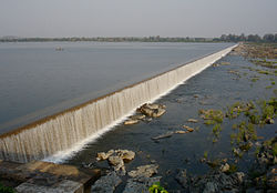
Sileru River

Last updated

Sileru River is a tributary of Sabari River in southern India. It originates in Andhra Pradesh and also flows through Odisha before merging with Sabari. Sabari river crosses the border into Andhra Pradesh to merge with Godavari river. [1] Sileru (known as Machkund in its upper reaches) river joins Sabari river tri-junction boundary point of Andhra Pradesh, Chhattisgarh and Odisha.

Contents

Hydro power potential

Sileru river has huge potential of hydro electricity generation which has been substantially harnessed by constructing Machkund (120 MW), Balimela (510 MW), Upper Sileru (240 MW), Donkarayi (25 MW) and Lower Sileru hydro (460 MW) power projects. [2] Chitrakonda (60 MW) hydro project located at the toe of Balimela earth dam is planned to utilise the head available across the earth dam. [3]

Irrigation potential

The water released from the Balimela power station is used for irrigation in the Potteru tributary basin of Sabari in Odisha. At present the water released from the other power stations is not useful to irrigation needs except during lean flow period in main Godavari river for the requirements of Godavari delta. Uttarandhra region can create huge irrigation potential with the perennial water supply from the available water storages in Seleru river basin. The mid lands of East Godavari district can get augmented water supply by diverting Sileru river water from Donkarayi reservoir (310 m MSL) towards east of Eastern Ghats by constructing 35 km long tunnel with enhanced power potential. [4] Similarly, mid lands of Vishakhapatnam District, Vizianagaram district and Srikakulam district can get augmented water supply by diverting Sileru river water from Guntawada weir (head works of Upper Sileru power station) at 410 m MSL towards east by constructing 30 km long tunnel with enhanced power potential. [5] The diverted water of Sileru river to the east can also be used to supply water to the Polavaram left bank canal and Visakhapatnam city's continuous drinking water needs when water level is not adequate in Polavaram reservoir during non monsoon months.

The water released from the Lower Sileru power station can be diverted to Yeleru reservoir by gravity with a 70 km long tunnel to create additional irrigation in East Godavari district. Part of the water released by Lower Sileru power station can also be used for the planned Lower Sileru irrigation scheme located in Sileru and Sabari basins.

See also

Related Research Articles

<span class="mw-page-title-main">Godavari River</span> River in India

The Godavari is India's second longest river after the Ganga river and drains into the third largest basin in India, covering about 10% of India's total geographical area. Its source is in Trimbakeshwar, Nashik, Maharashtra. It flows east for 1,465 kilometres (910 mi), draining the states of Maharashtra (48.6%), Telangana (18.8%), Andhra Pradesh (4.5%), Chhattisgarh (10.9%) and Odisha (5.7%). The river ultimately empties into the Bay of Bengal through an extensive network of tributaries. Measuring up to 312,812 km2 (120,777 sq mi), it forms one of the largest river basins in the Indian subcontinent, with only the Ganga and Indus rivers having a larger drainage basin. In terms of length, catchment area and discharge, the Godavari is the largest in peninsular India, and had been dubbed as the Dakshina Ganga.

<span class="mw-page-title-main">Dowleswaram Barrage</span> Dam in Rajamahendravaram, Andhra Pradesh

The Dowleswaram Barrage Or Dhavaleshwaram Barrage was an irrigation structure originally built in 1852 on the lower stretch of the Godavari River before it empties into the Bay of Bengal. It was rebuilt in 1970 when it was officially renamed as Sir Arthur Cotton Barrage or Godavari Barrage.

The Jalaput Dam is a hydroelectric dam built on the Machkund River, a tributary of the Godavari River in India which rises in the Mudugal hills of Alluri Sitharama Raju district District and nearby Ondra Gadda it becomes the boundary between Andhra Pradesh and Odisha. This Dam is the most ignored one in India, currently, it is in dilapidated condition. For over 48 km the river runs nearly north along a meandering course through the Padwa Valley. About 48 km south of Jeypore, it winds westward along the edge of the Plateau and then suddenly tums at a short angle to the south-west down a steep descent popularly known as Duduma Falls.

<span class="mw-page-title-main">Godavari River Basin Irrigation Projects</span>

The Godavari River has its catchment area in seven states of India: Maharashtra, Telangana, Chhattisgarh, Madhya Pradesh, Andhra Pradesh, Karnataka and Odisha. The number of dams constructed in Godavari basin is the highest among all the river basins in India. Nearly 350 major and medium dams and barrages had been constructed in the river basin by the year 2012.

The Balimela Reservoir is located in Malkangiri district, Odisha, India on the river Sileru which is a tributary of the Godavari river. The gross storage capacity of Balimela reservoir is 3610 million cubic meters.

<span class="mw-page-title-main">Nagarjuna Sagar Dam</span> Dam in Telangana and Palnadu district, Andhra Pradesh

Nagarjuna Sagar Dam is a masonry dam across the Krishna River at Nagarjuna Sagar which straddles the border between Nalgonda district in Telangana and Palnadu district in Andhra Pradesh. India. The dam provides irrigation water to the Nalgonda, Suryapet, Krishna, NTR, Bapatla, Eluru, Palnadu, Khammam, West Godavari, Guntur, and Prakasam districts along with electricity generation.

<span class="mw-page-title-main">Srisailam Dam</span> Dam in Telangana and Andhra Pradesh, India

The Srisailam Dam is constructed across the Krishna River in Nagarkurnool district, Telangana and Nandyal district, Andhra Pradesh near Srisailam temple town and is the 2nd largest capacity working hydroelectric station in India.

<span class="mw-page-title-main">Nagavali River</span> River in India

The River Nagavali also known as Langulya is one of the main rivers of Southern Odisha and North Andhra States in India, between Rushikulya and Godavari basins.

Budameru is a rivulet in Krishna district which originates in the hills surrounding Mylavaram and empties itself into Kolleru Lake. Budameru is also known as The Sorrow of Vijayawada. In order to control the floods, the river was dammed at Velagaleru village and a diversion channel named, Budameru Diversion Channel (BDC) was constructed from Velagaleru to join Krishna River upstream of Prakasam Barrage.

<span class="mw-page-title-main">Vamsadhara River</span> River in India

River Vamsadhara or River Banshadhara is an important east flowing river between Rushikulya and Godavari, in Odisha and Andhra Pradesh states in India.

<span class="mw-page-title-main">Sabari River</span> River in Andhra Pradesh, India

Sabari River is one of the main tributaries of Godavari. It originates from the western slopes of Eastern Ghats in Odisha state from Sinkaram hill ranges at 1370 m MSL. It is also known as Kolab river in Odisha.The Sabari river basin receives nearly 1250 mm annual average rainfall. It forms common boundary between Chhattisgarh and Odisha states and later enters into Andhra Pradesh to merge with River Godavari. Upper Kolab project, located in Odisha across the Sabari is a major dam project supplying water for irrigation and Hydro power generation.

<span class="mw-page-title-main">Polavaram Project</span> Dam in Eluru district, Andhra Pradesh

The Polavaram Project is an under construction multi-purpose irrigation project on the Godavari River in the Eluru District and East Godavari District in Andhra Pradesh. The project has been accorded National project status by the Central Government of India. Its reservoir back water spreads up to the Dummugudem Anicut and approx 115 km on Sabari River side. Thus back water spreads into parts of Chhattisgarh and Odisha States. It gives major boost to tourism sector in Godavari Districts as the reservoir covers the famous Papikonda National Park, Polavaram hydro electric project (HEP) and National Waterway 4 are under construction on left side of the river. It is located 40 km to the upstream of Sir Arthur Cotton Barrage in Rajamahendravaram City and 25 km from Rajahmundry Airport.

The Pranahita Chevella Lift Irrigation Project is a lift irrigation project to harness the water of Pranhita tributary of Godavari river for use in the Telangana state of India. The river water diversion barrage across the Pranahita river is located at Thammidihatti village in Komaram Bheem district of Telangana. This lift canal is an inter river basin transfer link by feeding Godavari river water to Krishna river basin. The chief ministers of Telangana and Maharashtra states reached an agreement in 2016 to limit the full reservoir level (FRL) of the barrage at 148 m msl with 1.85 tmcft storage capacity. In the year 2016, this project is divided into two parts. The scheme with diversion canal from the Thammmidihatti barrage to connect to existing Yellampalli reservoir across the Godavari river is presently called Pranahita barrage lift irrigation project. This scheme is confined to providing irrigation facility to nearly 2,00,000 acres in Adilabad district using 44 tmcft water.

The Pulichintala Project is a multi-purpose water management project for irrigation, hydropower generation, and flood control in the state of Andhra Pradesh, India. It is a crucial irrigation facility for farmers in four coastal districts: West Godavari, Krishna, Guntur, and Prakasam, covering over 13 lakh acres. It has 24 gates and a balancing reservoir with a capacity of 46 Tmcft at 175 feet (53 m) MSL full reservoir level (FRL).

<span class="mw-page-title-main">Rajiv Dummugudem Lift Irrigation Scheme</span>

Rajiv Dummugudem Lift Irrigation Scheme is a lift irrigation scheme under execution which are located near Dummugudem, Khammam district in Telangana, India. There are three lift irrigation schemes by names Rajiv Dummugudem lift irrigation scheme, Indirasagar Rudrammakota Dummugudem lift irrigation scheme and Dummugudem to Sagar tail pond canal project. Rajiv Dummugudem lift irrigation scheme starting at 17°54′05″N80°52′45″E is planned to supply irrigation water for 200,000 acres in Khammam and Warangal districts drawing Godavari River water from the Dummugudem pond. Indira Dummugudem lift irrigation scheme starting at 17°33′49″N81°14′49″E is planned to supply irrigation water for 200,000 acres in Khammam, Krishna and West Godavari districts drawing Godavari River water from the back waters of Polavaram reservoir.

Icchampally Project was a multi-purpose project proposed in 2008, with hydro electricity generation, irrigation, flood control, etc. benefits on the River Godavari in India. This project is proposed as joint project of Telangana, Maharashtra and Chhattisgarh states.

<span class="mw-page-title-main">Godavari Water Disputes Tribunal</span> Tribunal created by the government of India

The Government of India (GoI) constituted a common tribunal on 10 April 1969 to solve the river water utilization disputes about the river basin states of Godavari and Krishna rivers under the provisions of Interstate River Water Disputes Act – 1956. The common tribunal was headed by Sri RS Bachawat as its chairman with Sri DM Bhandari and Sri DM Sen as its members. Godavari river basin spreads through the states of Telangana (TS), Maharashtra (MR), Orissa, old Madhya Pradesh {later bifurcated into present Madhya Pradesh (MP) and Chhattisgarh}, Karnataka (K) and Andhra Pradesh (AP). Krishna river basin states Maharashtra, Karnataka and Andhra Pradesh insisted on the quicker verdict as it had become more expedient for the construction of irrigation projects in Krishna basin. So the of Godavari Water Disputes Tribunal (GWDT) could not proceed till the Krishna Water Disputes Tribunal final verdict was submitted to GoI on 27 May 1976.

<span class="mw-page-title-main">Nagarjuna Sagar tail pond</span> Reservoir in India

Nagarjuna Sagar tail pond is a multipurpose reservoir located 21 km downstream from the Nagarjuna Sagar Dam across the Krishna River near Satrasala in Nalgonda district, India. Its gross water storage capacity is 6 Tmcft. The reservoir water spread area extends up to the toe of the Nagarjuna Sagar dam. The project was completed by July 2014.

<span class="mw-page-title-main">Power sector of Andhra Pradesh</span>

Power sector of Andhra Pradesh is divided into 4 categories namely Regulation, Generation, Transmission and Distribution. Andhra Pradesh Electricity Regulatory Commission (APERC) is the regulatory body. APGENCO deals with the electricity production and also maintenance, proposes new projects and upgrades existing ones as well. The APGENCO also set up a Special Purpose Vehicle (SPV), named as Andhra Pradesh Power Development Company Limited (APPDCL), a joint venture company of APGENCO and IL&FS to set up Krishnapatanam thermal power project.

Pattiseema Lift Irrigation Project is a river interlinking project which connects Godavari River to Krishna River. This project has thereby become the first of such irrigation type projects in the country to be completed in time without any budget enhancements. It also holds a record in Limca Book of Records. The project was Inaugurated by the Chief Minister of Andhra Pradesh Nara Chandrababu Naidu in March 2016 while the project was completed in one year record of time.

References

  1. Britannica
  2. Andhra Pradesh Power Generation Corporation Ltd Archived 25 February 2012 at the Wayback Machine
  3. "AP, Orissa join hands to build hydel project" . Retrieved 4 November 2013.
  4. "Donkarai( S.H.E.S) D03456" . Retrieved 4 November 2015.
  5. "Guntawada Main Dam D06086" . Retrieved 4 November 2015.

Coordinates: 17°47′N81°24′E / 17.783°N 81.400°E / 17.783; 81.400