Palar is a river of southern India. It rises in the Nandi Hills in Chikkaballapura district of Karnataka state, and flows 93 kilometres (58 mi) in Karnataka, 33 kilometres (21 mi) in Andhra Pradesh and 222 kilometres (138 mi) in Tamil Nadu before reaching its confluence into the Bay of Bengal at Vayalur about 75 kilometres (47 mi) south of Chennai. It flows as an underground river for a long distance only to emerge near Bethamangala town, from where, gathering water and speed, it flows eastward down the Deccan Plateau. The Towns of Bethamangala, Santhipuram, Kuppam,Mottur, Ramanaickenpet, Vaniyambadi, Ambur, Melpatti, Gudiyatham, Pallikonda, Anpoondi, Melmonavoor, Vellore, Katpadi, Melvisharam, Arcot, Ranipet, Walajapet, Kanchipuram, Walajabad, Chengalpattu, Kalpakkam, and Lattur are located on the banks of the Palar River. Of the seven tributaries, the chief tributary is the Cheyyar River.

The Tungabhadra River is a river in India that starts and flows through the state of Karnataka during most of its course, Andhra Pradesh and ultimately joining the Krishna River near Murvakonda in Andhra Pradesh

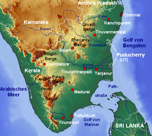
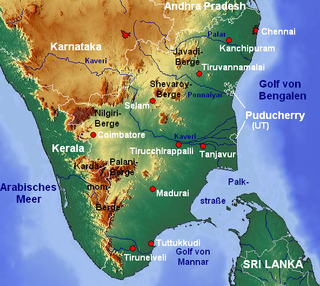
Krishnagiri district is one of the 38 districts of the state of Tamil Nadu, in India. This district is carved out from Dharmapuri District by 2004. The municipal town of Krishnagiri is the district headquarters. In Tamil Nadu, e-Governance was first introduced at Krishnagiri district under the National e-Governance Project (NEGP) in revenue and social welfare departments on a pilot basis. The district is one of the largest producers of mangoes in India. As of 2011, the district had a population of 1,879,809 with a sex-ratio of 958 females for every 1,000 males. Hosur is the most populous town in the district.
Bangalore is situated in the southeast of the South Indian state of Karnataka. It is positioned at 12.97° N 77.56° E and covers an area of 2,190 square kilometres (850 sq mi). A landlocked city, Bangalore is located in the heart of the Mysore Plateau at an average elevation of 920 metres (3,020 ft). Bangalore district borders with Kolar and Chikkaballapur in the northeast, Tumkur in the northwest, and Mandya and Ramanagaram in the southeast.
Chengam is an important market town and a taluk headquarter in the Foot hills of Eastern ghats in Tiruvannamalai district of Tamil Nadu, India. Chengam is the gateway to the Chengam pass in the Eastern ghats between Javvadhu hills to the north and Chennakesava hills to the south. The town is also the center for various industrial activities which includes Sathanur dam hydro-electric project, Aavin milk processing plant and Periya Kolappadi SIDCO estate.

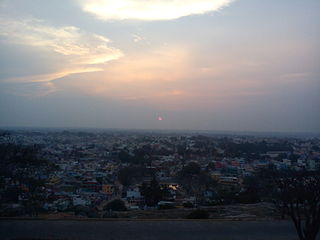
Krishnagiri is a city in the state of Tamil Nadu, India, and it serves as the administrative headquarters of Krishnagiri District formed in 2004. It is located at the bottom of Krishnadevaraya Hills, and the town is fully surrounded by hill rocks. It is located 250 km from Chennai, 45 km from Dharmapuri, and 90 km from Bengaluru. Krishnagiri is known as "Mango Capital of India" as mangoes are cultivated as the main crop, and the land here is extremely fertile with rich access to fresh water making it amenable to growing crops. Krishnagiri is the site of significant business and residential development. The Krishnagiri Dam was built in 1967.
Singarapettai is a town in Krishnagiri district in Tamil Nadu. In the 2011 census it had a population of 2253 in 537 households.
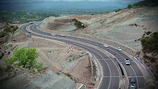
National Highway 44 is a major north–south National Highway in India and is the longest in the country.
Melmalayanur is located near Gingee, Tamil Nadu, India, 21 km from chetput and 21 km away from Gingee It is famous for the Goddess Angalaamman. Devotees across South India visit this temple to avail blessings of Angalaamman.
Hosur is an industrial city located in Krishnagiri district in the Tamil Nadu state of India. Hosur is one of the 21 municipal corporations in Tamil Nadu. It is located on the bank of the river River Ponnaiyar, 40 kilometres (25 mi) southeast of Bengaluru and 306 kilometres (190 mi) west of Chennai, the state capital. Hosur is home to major manufacturing industries including Stellantis, Ashok Leyland, Titan, TVS Motors, Caterpillar, Ather Energy, Schaeffler, and many others.

Tiruvannamalai district is the largest and one of the 38 districts in the state of Tamil Nadu, in South India. It was formed in the year 1989 through the bifurcation of North Arcot into the Tiruvannamalai Sambuvarayar and Vellore Ambedkar districts. The city of Tiruvannamalai is the district headquarters.
Krishnagiri, headquarters of Krishnagiri District, which is the Northern Gateway to Tamil Nadu, is well connected to all parts of south India by a strong network of national highways.
Markandeya or Markanda is a river in the Indian states of Karnataka and Tamil Nadu. It flows into the South Pennar River near Krishnagiri Dam in Krishnagiri district of Tamil Nadu.
This article gives a list of the territories of the dioceses of the Catholic Church in India.
Tiruvannamalai is predominantly connected by road to other major cities in the state including Chennai, Bengaluru, Vellore, Arani, Trichy, Tiruppur, Salem, Thanjavur, Coimbatore, Shimoga and Kanchipuram. And also other state major cities such as Hyderabad, Tirupati, Puducherry and Mangaluru. Tiruvannamalai serves as one of the important Road junction of Tamil Nadu and north roadways Zone. The nearest domestic airport is Vellore, which has a no daily chartered flights. The nearest international airports are Chennai and Tiruchirappalli.
Kandikuppam is a panchayat in Bargur Block Krishnagiri district in the state of Tamil Nadu, India. The economy is dependent on mango cultivation. Chennai is the state capital for Kandikuppam village. It is located around 223.5 kilometer away from Kandikuppam.. The other nearest state capital from Kandikuppam is Bangalore and its distance is 93.7 km. The other surrounding state capitals are Bangalore 93.7 km., Pondicherry 178.4 km., Thiruvananthapuram 463.4 km., Kandikuppam is located along Chennai – Krishnagiri National Highway. Banks and ATM: Indian Bank with ATM, 1 India ATM. Central Government own India Post Branch post office. The surrounding nearby villages and its distance from Kandikuppam are Achamangalam 2.6 km, Kurumber Theru 1.9 km, Thandavanpallam 1.5 km, Varattanapalli 4.3 km, Karakuppam 5.4 km, Bargur 6.6 km, Thogarapalli 6.7 km, Jagadevi 6.9 km, Mallapadi 8.0 km, Oppathavadi 10.1 km, Valasagoundanoor 21.9 km, Jingalkathirampatti 27.1 km, Parandapalli 28.5 km, Kottagaram.

Tirupathur or Tirupattur is the headquarters of Tirupathur district in the state of Tamil Nadu in India and is one of the oldest inhabited places in the state, with a history of over 1,600 years. The town is known for an abundance of sandalwood in the surrounding hills. It is located about 89 km (55 mi) from Vellore, 85 km (53 mi) from Hosur, 60 km (37 mi) from Dharmapuri, 50 km (31 mi) from Krishnagiri, 50 km (31 mi) from Thiruvannamalai, 210 km (130 mi) from Chennai, and 125 km (78 mi) from Bangalore.

Tiruvannamalai is a city, a spiritual, cultural, economic hub and also the administrative headquarters of Tiruvannamalai District in the Indian state of Tamil Nadu. The city is home to the renowned Annamalaiyar temple, Annamalai hill, Girivalam and the Karthigai Deepam festival and a prominent pilgrimage destination.
Vira Ramanatha was a king of the southern portion of the Hoysala Empire. In 1254 CE, Hoysala king Vira Someshwara divided his kingdom between his two sons, Narasimha III who ruled from Halebidu, their original capital, had got the greater part of the ancestral kingdom and Vira Ramanatha Deva obtained the remaining part consisting of the present Kolar district and the Tamil territories conquered by the Hoysalas in the south, and ruled from Kannanur Kuppam near Srirangam. Like his father Narasimha II, Someshwara stayed back at Kannanur with Ramanatha where he was killed in 1262/1263 CE in a war with Sadayavarman Sundara Pandyan I of the Pandya dynasty.