Badabail Maravanthe | |
|---|---|
Village | |
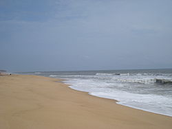 Maravanthe beach | |
 Badabail Maravanthe Location in Karnataka, India  Badabail Maravanthe Badabail Maravanthe (India) | |
| Country | |
| State | Karnataka |
| District | Udupi |
| Taluk | Byndoor |
| Languages | |
| • Official Languages | Kannada |
| Time zone | UTC+5:30 (IST) |
| PIN | 576224 |
| Website | www |
Maravanthe is a village and a beach in Byndoor Taluk, Udupi District, Karnataka, India.
Contents
NH-66 (formerly NH-17) runs next to the beach and the Souparnika River flows on the other side of the road. [1] Outlook traveller said it is one of Karnataka's most beautiful beaches. [2]
The Suparnika River, which almost touches the Arabian Sea there, makes a U-turn and goes westward to join the sea after a journey of nearly more than 10 km (6.2 mi).

