Jog Falls | |
---|---|
Joga Jalapatha Jogada gundi(pit) | |
![]() Jog Falls | |
![]() | |
Location | Jog Fall, [1] [2] Karnataka, India |
Type | Cataract, Segmented |
Elevation | 488 m (1,601 ft) |
Total height | 253 m (830 ft) [3] |
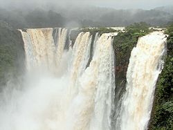
Number of drops | 4 (Raja (king), Rani (queen), Roarer, Rocket) [4] |
Longest drop | 254 m (833 ft) |
Average width | 472 m (1,549 ft) |
Watercourse | Sharavati River [5] |
Average flow rate | 153 m3/s (5,400 cu ft/s) |
Jog Falls [6] is a waterfall on the Sharavati river located in Siddapur taluk of Uttara Kannada district [7] and its view point in Kargal town of Shimoga district, Karnataka, India. [8] [9] It is the second highest plunge waterfall in India. [10] It is a segmented waterfall which depends on rain and season to become a plunge waterfall. The falls are major attractions for tourists and is ranked 36th in the list of free-falling waterfalls, 490th in the world by list of waterfalls by total height, 128th in the list of single-drop waterfalls in the World by the waterfall database. [11]
Jog Falls is created by the Sharavati river dropping 253 m (830 ft), making it the third-highest waterfall in India after the Nohkalikai Falls with a drop of 335 m (1,099 ft) in Meghalaya [12] and the Dudhsagar Falls with a drop of 310 m (1,020 ft) in Goa.
Sharavathi, a river which rises at Ambutirtha, next to Nonabur, in the Thirthahalli taluk, Shimoga district takes a northwesterly course by Fatte petta, receives the Haridravati on the right below Pattaguppe and the Yenne Hole on the left above Barangi. Then, it bends to the west, precipitates itself down the Jog Falls (aka Gersoppa Falls), and passes the village of Gersoppa (properly Geru-Sappe), which is some 30 kilometres (19 mi) away, discharging into the Arabian Sea at Honnavar in Uttara Kannada.
The Sharavathi, flowing over a very rocky bed about 250 yards (230 m) wide, reaches a tremendous chasm, 290 m (950 ft) deep, and the water comes down in four distinct falls, Raja, Rani, Roarer and Rocket. [13] The Raja Fall comes down in one unbroken column sheer to the depth of 250 m (830 ft). Halfway down, it is encountered by the Roarer, which precipitates itself into a vast cup and then rushes violently downwards to meet the Raja. The Rocket shoots downwards in a series of jets. The Rani moves quietly over the mountainside in a sheet of foam. The Tourism Department has built steps from the viewpoint at the top, where the waterfall can be seen from across, to the bottom of the hill. There are approximately 1,400 steps made to reach the bottom of the hill. [14]
Associated with the waterfall is the nearby Linganamakki Dam across the Sharavati River. [15] The water released from the dam adds to the beauty of the waterfalls in the monsoon season. [16] The power station has been operational since 1948 and is of 120 MW capacity, one of the largest hydroelectric stations in India at that time and a small source of electric power for Karnataka now. The power station was previously named Krishna Rajendra hydro-electric project, after the King of Mysore at that time. The name was later changed to Mahatma Gandhi Hydro-electric Project. It was served by The Hirebhaskara dam until 1960. After 1960, due to the ideas of Mokshagundam Visvesvarayya, Linganmakki Dam has been used for power generation. [17]
The hydro-electric project was conceived by the government of Mysore in mid-1943. A scheme to generate 64,000 horsepower at a cost of ₹358 lakh was designed. [18] The Power House on the right bank of the Gerusoppa dam consists of four Francis-type turbines coupled to the generating units of 60 MW each. The units are configured to operate at a design head of 47.5 mtrs. An outdoor switchyard is located between the toe of the dam and the power house. Power from the outdoor yard is evacuated through a 220 KV double circuit transmission line connected to the state grid at Talaguppa.
The capacity was increased subsequently and currently generates 240 MW of power. [19]
Jog Falls is situated Near Siddapura And Sagara city.
133 km (83 mi)
Uttara Kannada is a fifth largest district in the Indian state of Karnataka, It is bordered by the state of Goa and Belagavi districts to the north, Dharwad District and Haveri District to the east, Shivamogga District, and Udupi District to the south, and the Laccadive Sea to the west. Karwar is the district headquarters, Kumta and Sirsi are the major commercial centers in the district. The district's agroclimatic divisions include the coastal plain consisting of Karwar, Ankola, Kumta, Honnavar Bhatkal taluks and Malenadu consisting of Sirsi, Siddapur, Yellapur, Haliyal, Dandeli, Joida, Mundgod taluks.
Sharavati is a river which originates and flows entirely within the state of Karnataka in India. It is one of the few westward flowing rivers of India and a major part of the river basin lies in the Western Ghats. The famous Jog Falls, located about 25 km from Siddapura, is formed by this river. The river itself and the regions around it are rich in biodiversity and are home to many rare species of flora and fauna.
Sirsi is a city in the Uttara Kannada district of Karnataka state in India. It was also known as "Kalyana Pattana" during the Sonda Dynasty. It is a tourist destination with evergreen forest and waterfalls and is also a commercial centre. The main businesses around the city are mostly subsistence and agriculture-based. Areca nut or betel nut, locally known as Adike, is the primary crop grown in the nearby villages, making it one of the major trading centres for areca nut. The region is also known for spices such as cardamom, pepper, betel leaves, and vanilla. The major food crop is paddy.
Shimoga district, officially known as Shivamogga district, is a district in the Karnataka state of India. A major part of Shimoga district lies in the Malnad region or the Sahyadri. Shimoga city is its administrative centre. Jog Falls view point is a major tourist attraction. As of 2011 Shimoga district has a population of 17,52,753. There are seven taluks: Soraba, Sagara, Hosanagar, Shimoga, Shikaripura, Thirthahalli, and Bhadravathi. Channagiri and Honnali were part of Shimoga district until 1997 when they became part of the newly formed Davanagere district.
Hosanagara is a panchayat town in Shimoga district in the Indian state of Karnataka. It is nested in western ghats of India. The World Cattle Conference with main emphasis on cow was held in month of April 2007 in Hosanagar. The different uses of cow were exhibited. Near Hosanagar there is a mutt named Sri Ramachandrapura Math, 6 km from the town.
Varahi River originate and flows through Western Ghats in the Indian state of Karnataka. It is also known as Halady or Haladi river in downstream areas. It joins the Arabian sea after flowing through places like Halady, Basrur, Kundapura and Gangolli. It joins with the Souparnika River, Kedaka River, Chakra River, and Kubja River which are known by Panchagangavalli River and merges into the Arabian Sea. Pancha means five in Kannada and Samskrita and Ganga means river. According to mythology, Varaha is one of the incarnations of Lord Vishnu. Varahi is the sister of lord Varaha-vishnu
Karnataka, the sixth largest state in India, has been ranked as the third most popular state in the country for tourism in 2014. It is home to 507 of the 3600 centrally protected monuments in India, second only to Uttar Pradesh. The State Directorate of Archaeology and Museums protects an additional 752 monuments and another 25,000 monuments are yet to receive protection.
The Linganamakki Dam was constructed by the Karnataka State Government in 1964. Located in the Kargal village of Sagara taluk, the dam has a length of 2.74 kilometres (1.70 mi) stretching across the Sharavathi river. It is located about 9 km from Jog Falls. It has an effective storage capacity of 4.29 cubic km or 151.52 tmc ft of water. This dam too is basically used for generation of hydro electricity like Supa dam.
Honnemaradu is a tourist place situated on the back waters of River Sharavathi in India. Honnemardu derived its name from the Honne tree. However, the literal meaning of Honnemardu is Golden Lake. This is perhaps a reference to the fact that Honnemardu is located on the backwaters of the Sharavathi river.
Kunchikal Falls is a waterfall in India located in the Nidagodu village near Masthikatte in the Shimoga district of Karnataka state. Kunchikal Falls cascades down rocky boulders and the total height of the falls is 455 meters, according to the World Waterfall Database. Kunchikal Falls is formed by the Varahi river.
Siddapura is a town and the headquarters of Siddapur taluk, It is located at a distance of 39 km (24 mi) from Sirsi through SH 93. it is part Uttara Kannada district in Karnataka. It is nestled among the Malenadu region. The town is surrounded by forests and lush greenery, and the region is popular for its many waterfalls. It is known for its proximity to Jog Falls, Adike is the primary crop grown in the villages that surround the town.
Talaguppa is a village located in Sagara Taluk in Karnataka State, India. The National Highway No.206 passes through Talaguppa village. The village is 14.37 km from the taluk's center Sagara, 77.68 km from Shivamogga, and 373 km from Bengaluru. It is located at a distance of 14 km from Jog Falls, the highest waterfall in India and Talaguppa is the linking Railway terminus for Jog falls. Areca nut and paddy are the most grown crops.Main reserve station of electricity generated from jog falls and linganamakki dam located here.
Harana Halli is a village in the southern state of Karnataka, India. It is located in the Shimoga taluk of Shimoga district in Karnataka. Harana Halli is about 21 km from Shimoga town. The trains operating from Birur to Sagara go via Harana Halli railway station. The famous Shimoga-Talaguppa railway (RailBus) route which provides access to Jog Falls goes via Harana Halli. The Rail bus service is now stopped.
The following outline is provided as an overview of and topical guide to Karnataka:
Kattinahole is a small village in Hosanagara Taluk, Shimoga district of the Indian state of Karnataka. The local language of Kattinahole is Kannada.
Hittalakoppa is one of the major villages of Siddapura taluk in Karwar District, India. It is 11 km away from Siddapur and 25 km away from Sagar city, 77 km from the city of Shimoga, 216 km from port city Mangalore and 323 km from state capital Bangalore.
Honnavar Taluk is one of the five coastal taluks in the district of Uttara Kannada in Karnataka, India.
Sagara is a city located in the Indian state of Karnataka. It is also a sub divisional and a taluk headquarters. Located in the Sahyadri Mountain range on the banks of river Varada, it is known for its proximity to Jog Falls and to the historical places of Ikkeri, Keladi and Varadamoola. The river Varada originates near Varada-moola. Sagara subdivision consists of Sagara, Soraba, Hosanagara and Shikaripur taluks.
Talavata is a village in the southern state of Karnataka, India. It is located in the border of Shimoga district and Uttara Kannada District. Its taluk is Sagara, Karnataka.
Sharavathi Wildlife Sanctuary is a protected wildlife sanctuary in the Western Ghats of Karnataka state in India. It is named after the Sharavathi River flowing through the sanctuary. The sanctuary is spread across the forests of Uttara Kannada & Shivamogga districts of Karnataka, Sharavathi Reservoir is present within the sanctuary. The nearest town Sagara is 34 km away and is connected by bus service to Shivamogga, Hubballi, Mangaluru and Bengaluru on a daily basis. The nearest railway station Thalaguppa is 15 Km away, while the nearest airport viz. Mangalore is located about 200 Km from the sanctuary.