Kabini River

Last updated

Kapila
Kabani River.jpg
Kapila River from Kabinigiri, Kerala
Location
Country India
State Kerala, Karnataka
Physical characteristics
Source Panamaram
  location Wayanad district, Kerala, India
  coordinates 11°48′01″N76°04′29″E / 11.80028°N 76.07472°E / 11.80028; 76.07472
Mouth Tirumakudal Narsipur
  location
Mysore district, Karnataka, India
  coordinates
12°12′56″N76°54′40″E / 12.21556°N 76.91111°E / 12.21556; 76.91111

The Kabini River is one of the major tributaries of the river Cauvery in southern India. [1] It originates near Kavilumpara in Kozhikode district of Kerala state by the confluence of the Panamaram River and the Mananthavady River. It flows eastward through Wayanad district, entering Mysore district of Karnataka, to join the Kaveri River in Mysore district of Karnataka

Contents

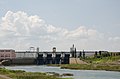
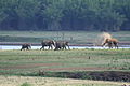
Close to the town of Sargur it forms the huge Kabini Reservoir. [2] The backwaters of the Kabini reservoir are very rich in wildlife especially in summer when the water level recedes to form rich grassy meadows. The Kabini dam is 2,284 ft (696 m) in length with an original gross storage of 19.52 tmcft. The Kabini Dam is situated between villages Bichanahalli and Bidarahalli having distance of 17 km (11 mi) 6 km away from Sargur town in Heggadadevana kote taluk, Mysore district, Karnataka.

Wildlife

The Kabini Forest Reserve is one of the most popular wildlife destinations of Karnataka, probably because of its accessibility, lush green landscape surrounding a large lake, and sightings of herds of elephants, tigers. It is 61 km (38 mi) away from Mysuru and 205 km (127 mi) from Bengaluru, and comprises the south-eastern part of Nagarahole National Park. Situated on the banks of the kabini River, the reserve is spread over 55 acres (22 ha) of forestland, steep valleys, and water bodies. Once a private hunting lodge of the Maharaja of Mysore, kabini was a popular shikar hotspot for British Viceroys and Indian royalty. Now it is considered to be one of the best Wildlife National Parks in India, famous for its spectacular wildlife and bird life. There are around 120 tigers, 100+ leopards, four types of deer, Sloth bear, Indian Gaurs and elephants in the Nagarahole National Park.[ citation needed ]

Course

Panoramic view of central Kabini Reservoir, Karnataka Kabini Reservoir Central Sky SE View Pano Karnataka Dec21 D72 21841-842.jpg
Panoramic view of central Kabini Reservoir, Karnataka

The river originates in the Pakramthalam hills at Kuttiady-Mananthavady road. Makkiyad river and Periya river join it near Korome and Valad respectively. After flowing through Mananthavady town, Panamaram river joins Kabini near Payyampally. One branch of the Panamaram river starts from the Banasura Sagar reservoir near Padinjarethara and the other branch of the river start from Lakkidi hills. After traversing 2 kilometres (1.2 mi) from the confluence of Panamaram river kabini forms an island called Kuruva Island, spreading over 520 acres (2.1 km2) with diverse flora and fauna. Within 20 km (12 mi) it reaches the kabini reservoir bordering Kerala and Karnataka for some distance. Between kabini reservoir and Kuruva island Kalindi river joins kabini. Kalindi river originates from Brahmagiri hills which on reaching near Thirunelli Temple the rivulet Papanasini joins it. Taraka and Nugu are the two small rivers in Heggadadevana kote taluk that join the Kapila (Kabini river).[ citation needed ].

Kabini dam

Kabini dam
Kabini dam full view.jpg
Coordinates 11°58′25″N76°21′10″E / 11.9735°N 76.3528°E / 11.9735; 76.3528
Dam and spillways
Type of dam Earthen Dam with Left Bank spillway
ImpoundsKapila River
Height166 ft. above River Bed Level
Length12,927 ft.

The Kabini dam is built on the River Kapila in the district of Mysore. The dam is 696 meters in length and was built in 1974. The exact location of the dam is near village Beechanahally, in Taluk Heggadadevanakote. The catchment area of the dam is 2,141.90 km2. It caters to the needs of around 22 villages and 14 hamlets and also a prominent source of drinking water to Mysuru and Bengaluru. Further significant amount of water is discharged to the Mettur reservoir in Tamilnadu to fulfill the state's needs.[ citation needed ]

This dam also provides water to the combined system of Sagaredoddakere and Upper Nugu Dams. There is an arrangement of lifting and transfer of 28.00 TMC of water during the monsoons months from the kabini dam to the other two smaller dams. The dam is spread over an area of 55 hectares covering forests, rivers, lakes and valleys.[ citation needed ]

Kabini Bridge

The Kabini Bridge on this river is a Heritage monument.

Related Research Articles

<span class="mw-page-title-main">Wayanad district</span> District in Kerala, India +91

Wayanad is a district in the north-east of the Indian state of Kerala, with administrative headquarters at the municipality of Kalpetta. It is the only plateau in Kerala. The Wayanad Plateau forms a continuation of the Mysore Plateau, the southern portion of Deccan Plateau which links the Western Ghats with the Eastern Ghats. It is set high in the Western Ghats with altitudes ranging from 700 to 2100 meters. Vellari Mala, a 2,240 m (7,349 ft) high peak situated on the trijunction of Wayanad, Malappuram, and Kozhikode districts, is the highest point in Wayanad district. The district was formed on 1 November 1980 as the 12th district in Kerala, by carving out areas from Kozhikode and Kannur districts. An area of 885.92 km2 of the district is forested. Wayanad has three municipal towns—Kalpetta, Mananthavady and Sulthan Bathery. There are many indigenous tribes in this area. The Kabini River, a tributary of Kaveri River, originates at Wayanad. Wayanad district, along with the Chaliyar valley in neighbouring Nilambur in Malappuram district, is known for natural gold fields, which are also seen in other parts of the Nilgiri Biosphere Reserve. Chaliyar river, which is the fourth longest river of Kerala, originates on the Wayanad plateau. The historically important Edakkal Caves are located in Wayanad district.

<span class="mw-page-title-main">Nanjangud</span> Town in Karnataka, India

Nanjangud, officially known as Nanjanagudu, is a town in the Mysuru district of Indian state of Karnataka. Nanjangud lies on the banks of the river Kapila, 23 km from the city of Mysore. Nanjangud is famous for the Srikanteshwara Temple located here. Nanjangud is also called Dakshina Kashi. This town is also famous for a type of banana grown in the region called the Nanjanagoodu rasabale. Nanjangud's local administrative unit was designated as a Municipal Committee in 2015 by including Devirammanahalli and Kallahalli village.

<span class="mw-page-title-main">Bhadravati, Karnataka</span> City in Karnataka, India

Bhadravati or Bhadravathi is an industrial city or Steel Town and taluk in the Shivamogga District of Karnataka state, India. It is situated at a distance of about 255 kilometres (158 mi) from the state capital Bengaluru and at about 20 kilometres (12 mi) from the district headquarters, Shivamogga. The town is spread over an area of 67.0536 square kilometres (25.8895 sq mi) and has a population of 151,102 as per the census held in 2011.

<span class="mw-page-title-main">Nagarhole National Park</span> National park in Karnataka, India

Nagarahole National Park is a national park located in Kodagu district and Mysore district in Karnataka, India.

<span class="mw-page-title-main">Oorpally</span> Town in Kerala, India

Oorpally is a small village near Koyileri, Mananthavady on the banks of the river Kabini in the Wayanad district of Kerala state, south India.

<span class="mw-page-title-main">Kuruvadweep</span>

Kuruvadweep or Kuruva Island is a 950-acre (3.8 km2) protected river delta. It comprises three densely wooded uninhabited islands and a few submergible satellite islands, which lies on the banks of the tributaries of Kabini River in the Wayanad district, Kerala, India. It is uninhabited island, which is home to rare species of birds, orchids, herbal plants etc.

<span class="mw-page-title-main">Gonikoppal</span> Town in Karnataka, India

Gonikoppal is a census town in the Kodagu district of the Indian state of Karnataka.

<span class="mw-page-title-main">Heggadadevanakote</span> Town in Karnataka, India

Heggadadevanakote or H.D.Kote is a town and a taluk headquarters in Mysore district in the Indian state of Karnataka. Kakana kote forest lies in Heggadadevana kote taluk. H.D Kote city is divided into 13 wards for which elections are held every 5 years.

<span class="mw-page-title-main">Thirumakudalu Narasipura</span> Town in Karnataka, India

Tirumakudalu Narasipura the temple city of Karnataka, commonly known as T. Narasipura or T.N. Pura, is a town in Mysore district in the Indian state of Karnataka. The first name refers to the land at the confluence, (trimakuta in Sanskrit at the confluence of the Kaveri, Kabini and Spatika Sarovara.

<span class="mw-page-title-main">Tourism in Karnataka</span> Overview of tourism in Karnataka, India

Karnataka, the sixth largest state in India, has been ranked as the third most popular state in the country for tourism in 2014. It is home to 507 of the 3600 centrally protected monuments in India, second only to Uttar Pradesh. The State Directorate of Archaeology and Museums protects an additional 752 monuments and another 25,000 monuments are yet to receive protection.

<span class="mw-page-title-main">Sargur</span> Town in Karnataka, India

Sargur, is a small town located about 80 km from the town of Chamarajanagar And a Taluk of Mysore district of Karnataka, India. H D Kote (Heggadadevanakote) is about 12 km north of Sargur. It is 55 km from the city of Mysore. Bangalore International Airport is 200 km away. To be more elaborate, Sargur is 33.8 km from Nanjangud town (Karnataka), 35.1 km from Gundlupet town (Karnataka), 137.8 km from Udagamandalam town (Ooty) Valley and 38.8 km from Hunsur town (Karnataka).

<span class="mw-page-title-main">Wildlife of Karnataka</span>

The state of Karnataka in South India has a rich diversity of flora and fauna. It has a recorded forest area of 38,720 km2 which constitutes 22% of the geographical area of the state. These forests support 25% of the elephant population and 20% of the tiger population of India. Many regions of Karnataka are still unexplored and new species of flora and fauna are still found. The mountains of the Western Ghats in the western region of Karnataka are a biodiversity hotspot. Two sub-clusters of the Western Ghats, Talacauvery and Kudremukh, are on a tentative list of sites that could be designated as World Heritage Sites by UNESCO. The Bandipur and Nagarahole national parks which fall outside these subclusters were included in the Nilgiri biosphere reserve in 1986, a UNESCO designation. In the Biligiriranga Hills the Eastern Ghats meet the Western Ghats. The state bird and state animal of Karnataka are Indian roller and the Indian elephant. The state tree and state flower are sandalwood and lotus. Karnataka is home to 524 tigers.

Chamalapura is a village situated in H D Kote Taluk, Mysore district, Karnataka, India.

<span class="mw-page-title-main">Kutta</span> Place in Karnataka, India

Kutta is a small village in Ponnampet taluk of Kodagu, in Karnataka state of India. As per census survey 2011, location code number of Kutta is 618078.

<span class="mw-page-title-main">Panamaram</span> Town in Kerala, India

Panamaram is a town,village in Wayanad district in the state of Kerala, India.

<span class="mw-page-title-main">Payyampally</span> Town in Kerala, India

Payyampally is a town in Wayanad district in the state of Kerala, India.

<span class="mw-page-title-main">Hullahalli</span> Village in Karnataka, India

Hullahalli is a village in the southern state of Karnataka, India. It is located in the Nanjangud taluk of Mysore district in Karnataka.

<span class="mw-page-title-main">Kabini dam</span> Dam in Karnataka, India

The Kabini dam is built on the Kabini River in Bidarahally and Beechanahally villages of Heggadadevanakote Taluk in Mysore district of Karnataka, India. The dam has a Length of 966 metres (3,169 ft) and it was built in 1974. The main purpose of the dam is to provide drinking water and irrigation of 22 villages and 14 hamlets and also generate electricity. The dam also provides water to two other dams which are Sagaredoddakere and Upper Nugu Dams. It is an earthen dam with a masonry spillway on the left bank. The dam has a height of 166 feet (51 m) and a length of 12,927 feet (3,940 m). The length of the Spillway is 250 feet (76 m), and it has 4 spillway gates. The reservoir filling period is June to November and depleting period is November to May. It is a part of mini hydel power project.

<span class="mw-page-title-main">D.B.Kuppe</span> Place in Karnataka, India

D.B. Kuppe or Doddabyrankuppe is a small village on the banks of the Kabini River in Mysore district, Karnataka state, India. It comes under the jurisdiction of Heggadadevana kote taluk.

<span class="mw-page-title-main">Tourist attractions in Wayanad</span>

The Wayanad District of Kerala, India has a wide variety of tourist attractions ranging from religious sites to natural, and historical sites. This district is divided into three towns, Kalpetta, Sultan Bathery and Mananthavady. All Major Tourism destinations in the district are maintained by the District Tourism Promotion Council.

References

  1. Kabbani River (Approved) at GEOnet Names Server, United States National Geospatial-Intelligence Agency
  2. "Salient Features kabini".