Amaravati River

Last updated

Amaravathi River
Aanporunai
Map River Amaravathi EN.svg
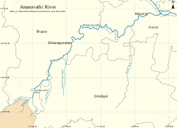
River Amaravathi and its tributaries
Etymologyfrom Purananuru 36
Location
Country India
Location Udumalaipettai- Dharapuram-Aravakurichi-Karur, Tamil Nadu
Physical characteristics
Source 
  location Anamalai Hills,
Chinnar River, Pambar River at
  coordinates 10°21′2″N77°14′14″E / 10.35056°N 77.23722°E / 10.35056; 77.23722
  elevation473 meters (1,552 ft)
Mouth  
  location
Karur at
  coordinates
10°57′36″N78°4′53″E / 10.96000°N 78.08139°E / 10.96000; 78.08139
  elevation
360 feet (110 m)
Length282 kilometers (175 mi)
Basin size8,380 square kilometers (3,240 sq mi) [1]
Basin features
River system Kaveri
Tributaries 
  right Nanganji, Kodavanar

The Amaravati River is the longest tributary[ citation needed ] of the Kaveri River in the fertile districts of Udumalpet, Dharapuram and Karur Tamil Nadu state, South India.

Contents

Course

The 282-kilometre (175 mi) long Amaravati River begins at the Kerala/Tamil Nadu border at the bottom of Manjampatti Valley between the Anaimalai Hills and the Palni Hills in Indira Gandhi Wildlife Sanctuary and National Park in Tirupur district. It descends in a northerly direction through Amaravathi Reservoir and Amaravathi Dam at Amaravathinagar. It is joined by the Kallapuram River at the mouth of the Ajanda valley in Udumalaipettai. Through Dharapuram and Aravakurichi it joins with the Kaveri at Thirumukkudalur, about 10 kilometres (6 mi) from Karur.[ citation needed ]

Nanganji, Kodavanar, Shanmuga nadhi, Uppar, Kudumiar, Thenar and many other tributaries join with the Amravati river. Other tributaries also include Pambar and Chinnar rivers from Kerala.[ citation needed ]

Use

This river irrigates over 60,000 acres (240 km2) of agricultural lands in Tiruppur and Karur districts. [2] The Amaravathi Dam has 4 megawatts of electricity generating capacity installed. The Amaravathi River and its basin, especially in the vicinity of Karur, are heavily used for industrial processing water and waste disposal and as a result are severely polluted due to large amount of textile dyeing and bleaching units. But nowadays in karur, the changes are vicinity by seeing Amaravati river on its clean surface because of pollution controlled by government. [3]

History

The ancient names of the river is Aanporunai and Aambravathi. Amaravathi, invokes the greenery and Kalpavriksha tree of Lord Indra's heaven. The name Amaravathi echoes the Hindu past and present of southern India. By Hindu religion, river is from the grace of goddess Ambaal form the heaven. The Amaravathi river swells into life in the Anjanad valley (Anaimalai, Kerala state) of the Western Ghats, whose slopes are awash with Kurinji blossoms once every 12 years, descends to the plains near Udumalaipettai, Tamil Nadu, and flows to make the rich plains of Dharapuram and Karur . It is one of the longest rivers (282 km) in Tamil Nadu, which join with the river Cauvery, near Karur.[ citation needed ]

Notes

  1. "Integrated Hydrological Data Book" (PDF). India. p. 76. Archived from the original (PDF) on 20 May 2014. Retrieved 25 March 2014.
  2. The Hindu, M. Gunasekaran To assess water loss in Amaravathi basin 2 April 2007
  3. Marcus Moench, Rethinkng the Mosaic, Investigations into Local Water Management, Addressing Constraints in Complex Systems, Chapter 1: Meeting the Water Management Needs of South Asia in the 21st Century Archived 21 November 2008 at the Wayback Machine , pub: Nepal Water Conservation Foundation, Kathmandu, and the Institute for Social and Environmental Transition, Boulder, Colorado, U.S.A., 1999, pp 145-146

Related Research Articles

Amaravati is the legislative capital and the de facto seat of government of the Indian state of Andhra Pradesh.

<span class="mw-page-title-main">Kaveri</span> River in southern India

The Kaveri is one of the major Indian rivers flowing through the states of Karnataka and Tamil Nadu. The Kaveri River rises at Talakaveri in the Brahmagiri range in the Western Ghats, Kodagu district of the state of Karnataka, at an elevation of 1,341 m above mean sea level and flows for about 800 km before its outfall into the Bay of Bengal. It reaches the sea in Poompuhar, in Mayiladuthurai district. It is the third largest river – after Godavari and Krishna – in southern India, and the largest in the state of Tamil Nadu, which, on its course, bisects the state into north and south. In ancient Tamil literature, the river was also called Ponni.

<span class="mw-page-title-main">Erode district</span> District of Tamil Nadu in India

Erode District is one of the 38 districts in the state of Tamil Nadu in India. It was the largest district by area in the state before the formation of Tirupur District in 2009. The headquarters of the district is Erode. It is divided into two revenue divisions, Erode and Gobichettipalayam, and is further subdivided into 10 taluks. Erode District was a part of Coimbatore District before its division into two on 17 September 1979. It covers an area of 5,722 square kilometres (2,209 sq mi), and as of 2011, had a population of 2,251,744.

<span class="mw-page-title-main">Noyyal River</span> River in India

The Noyyal River is a small river in Western Tamil Nadu, and a tributary of Kaveri River. It rises from the Vellingiri hills in the Western Ghats in Tamil Nadu, very closer in proximity to Kerala border, and flows through many villages and the cities of Coimbatore, and Tirupur. Then finally, the river drains into the Kaveri River at Noyyal, a village in Karur district named after the river itself. The river's basin is 180 km (110 mi) long and 25 km (16 mi) wide and covers a total area of 3,500 km2 (1,400 sq mi). Cultivated land in the basin amounts to 1,800 km2 (690 sq mi) while the population density is 120 people per km² (311/mi²) in the countryside, and 1000 people per km² (2590/mi²) in the cities. The area is known for its scanty rainfall and the development of the Noyyal River Tanks System to hold any overflow from the rains plus the water of the Northeast and Southwest monsoon season was ecologically important. Kausika river, which originates along the northern side of Coimbatore district in the Western Ghats along with its consequent streams, lake and pond systems is an important tributory of the river. The 173 km (107 mi) long tributary of the Kaveri River filled 32 tanks. These interconnecting tanks held the water flowing from the Noyyal.

<span class="mw-page-title-main">Bhavani River</span> River in India

Bhavani is an interstate Indian river which flows through Indian states of Kerala and Tamil Nadu, India. It originates from the Western Ghats and is one among the three rivers of Kerala which flows in eastward direction.

<span class="mw-page-title-main">Vaigai River</span> River in south India

The Vaigai is a river in the Tamil Nadu state of southern India; it passes through the towns of Theni, Madurai and Ramanathapuram. It originates in Varusanadu Hills, the Periyar Plateau of the Western Ghats range, and flows northeast through the Kambam Valley, which lies between the Palani Hills to the north and the Varushanad Hills to the south. The Vattaparai Falls are located on this river. As it rounds the eastern corner of the Varushanad Hills, the river turns southeast, running through the region of Pandya Nadu. Madurai, the largest city in the Pandya Nadu region and its ancient capital, lies on the Vaigai. The river empties into the Palk Bay near Alagankulam, close to Pamban Bridge in Ramanathapuram District.

<span class="mw-page-title-main">Palakkad Gap</span> Mountain pass in South India

Palakkad Gap or Palghat Gap is a low mountain pass in the Western Ghats between Coimbatore in Tamil Nadu and Palakkad in Kerala. It has an average elevation of 140 metres (460 ft) with a width of 24–30 kilometres (15–19 mi). The pass is located between the Nilgiri Hills to the north and Anaimalai Hills to the south.

<span class="mw-page-title-main">Periyar River</span> River in Kerala, India

Periyar, IPA:[peɾijɐːr], is the longest river and the river with the largest discharge potential in the Indian state of Kerala. It is one of the few perennial rivers in the region and provides drinking water for several major towns. The Periyar is of utmost significance to the economy of Kerala. It generates a significant proportion of Kerala's electrical power via the Idukki Dam and flows along a region of industrial and commercial activity. The river also provides water for irrigation and domestic use throughout its course besides supporting a rich fishery. Due to these reasons, the river has been named the "Lifeline of Kerala". Kochi city, in the vicinity of the river mouth draws its water supply from Aluva, an upstream site sufficiently free of seawater intrusion. Twenty five percent of Kerala's industries are along the banks of river Periyar. These are mostly crowded within a stretch of 5 kilometres (3 mi) in the Eloor-Edayar region (Udhyogamandal), about 10 kilometres (6 mi) north of Kochi harbor.

<span class="mw-page-title-main">Palani</span> Town in Tamil Nadu, India

Palani (Tamil:[paɻani] or Palnias in British records, is a town and a taluk headquarters in Dindigul district of the western part of Tamil Nadu state in India. It is located about 106 kilometres south-east of Coimbatore and 122 kilometres north-west of Madurai, 67 kilometres from Kodaikanal. The Palani Murugan Temple or Arulmigu Dhandayuthapani Swamy Temple, dedicated to Murugan is situated on a hill overlooking the town. The temple is visited by more than 7 million pilgrims each year. As of 2011, the town had a population of 292301 which makes it the second largest town in the district after Dindigul.

<span class="mw-page-title-main">Anaimalai Hills</span> Mountain range in India

The Anamala or Anaimalai, also known as the Elephant Mountains, are a range of mountains in the southern Western Ghats of central Kerala and span the border of western Tamil Nadu in Southern India. The name anamala is derived from the Malayalam word aana and the Tamil word yaanai, meaning elephant, or from tribal languages. Mala or Malai means 'mountain', and thus literally translatable as 'Elephant mountain'.

<span class="mw-page-title-main">Anamalai Tiger Reserve</span> Wildlife sanctuary and national park in Tamil Nadu, India

Anaimalai Tiger Reserve, earlier known as Indira Gandhi Wildlife Sanctuary and National Park and as Anaimalai Wildlife Sanctuary, is a protected area in the Anaimalai Hills of Pollachi and Valparai taluks of Coimbatore District and Udumalaipettai taluk in Tiruppur District, Tamil Nadu, India. The Tamil Nadu Environment and Forests Department by a notification dated 27 June 2007, declared an extent of 958.59 km2 that encompassed the erstwhile IGWLS&NP or Anaimalai Wildlife Sanctuary, as Anaimalai Tiger Reserve under the Wildlife Protection Act, 1972. According to the National Tiger Conservation Authority, the Reserve presently includes a core area of 958.59 km2 and buffer/peripheral area of 521.28 km2 forming a total area of 1479.87 km2.

<span class="mw-page-title-main">Dharapuram</span> Historical town in Tamil Nadu, India

Dharapuram is a town situated along the banks of Amaravati River in Tiruppur district in the Indian state of Tamil Nadu. Dharapuram is one of the oldest towns in South India and was the capital of Kongu Nadu under the Cheras, Western Ganga Dynasty and later Kongu Cholas, at which time it was known as Viradapuram. Amaravathi River flows through the town. As of 2011, the town had a population of 67,007. The city houses famous temples including Agatheeswarar Temple, Kaadu Hanumanthasamy temple and many others.

Mulanur is a panchayat town under in Dharapuram taluk in Tirupur District in the Indian state of Tamil Nadu.

<span class="mw-page-title-main">Udumalaipettai</span> Town in Tamil Nadu, India

Udumalai, also known as Udumalaipettai and Udumalpet, is a town in Tiruppur district in the Indian state of Tamil Nadu. Udumalaipettai is located 535 km south west from the state capital, Chennai and 72 km away from Coimbatore, the second largest city in the state.

<span class="mw-page-title-main">Valparai</span> Town in Tamil Nadu, India

Valparai is a Taluk and hill station in the Coimbatore district of Tamil Nadu, India. It consists of Anamalai Tiger Reserve. It is located 3,474 feet (1,059 m) above sea level on the Anaimalai Hills range of the Western Ghats. There are a total of 56 estates here. The game of football is very popular here. State level competitions are held every year. The foothill starts exactly from Monkey Falls which is at a distance of 38 kilometres (24 mi) to Valparai. The route to Valparai from the foothills consists of 40 hairpin bends. The Kerala state border town of Malakkappara is at a distance of 27 kilometres from Valparai. While major portions of the land are owned by private tea companies, large forest areas continue to be out of bounds.

<span class="mw-page-title-main">Manjampatti Valley</span>

Manjampatti Valley is a 110.9 km2 (42.8 sq mi) protected area in the eastern end of Indira Gandhi Wildlife Sanctuary and National Park (IGWS&NP) in Tirupur District, Tamil Nadu, South India. It is a pristine drainage basin of shola and montane rainforest with high biodiversity recently threatened by illegal land clearing and cultivation.

<span class="mw-page-title-main">Pambar River (Kerala)</span> River in Idukki district of Kerala, India

Pambar River originates near Anamudi in Idukki district of Kerala state in South India.

<span class="mw-page-title-main">Amaravathi Dam</span> Dam on the Amaravathi River in India

The Amaravathi Dam is a dam constructed across the Amaravathi River. It is located at Amaravathinagar, 25 kilometres (16 mi) south of Udumalpet on SH 17 in the Indira Gandhi Wildlife Sanctuary, Tirupur district in the Indian state of Tamil Nadu. The associated Amaravathi Reservoir is 9.31 square kilometres (3.59 sq mi) in area and 33.53 metres (110.0 ft) deep. The dam was built primarily for irrigation and flood control and now also has four megawatts of electrical generating capacity installed. It is notable for the significant population of mugger crocodiles living in its reservoir and catchment basin.

<span class="mw-page-title-main">Tiruppur district</span> District of Tamil Nadu in India

Tiruppur District is one of the 38 districts of the Indian state of Tamil Nadu, formed in 22 February 2009. Dharapuram was the largest taluk by area in the district. The district is well-developed and industrialized. The Tiruppur banian industry, the cotton market, Kangeyam bull and Uthukkuli butter, among other things, provide for a vibrant economy. The city of Tiruppur is the administrative headquarters for the district. As of 2011, the district had a population of 2,479,052 with a sex-ratio of 989 females for every 1,000 males.

<span class="mw-page-title-main">Siruvani River</span> River

The Siruvani River is a river near Coimbatore, India. It is tributary of Bhavani river, which in turn is a tributary of Kaveri. Part of the Siruvani River is near Mannarkkad in the Indian District of Palakkad, Kerala. The river leads into two big tourist attractions in Southern India, namely, the Siruvani Dam and the Siruvani Waterfalls. The dam is also near The Banan Fort. Banan Fort and the Siruvani Dam, are 15 to 25 kilometres west of Coimbatore city. The river has a village named after it, or possibly vice versa.