The Kaveri is an Indian river flowing through the states of Karnataka and Tamil Nadu. In Ancient times, It was also called as Ponni in Tamil literature. The Kaveri river rises at Talakaveri in the Brahmagiri range in the Western Ghats, Kodagu district of the state of Karnataka, at an elevation of 1,341 m above mean sea level and flows for about 800 km before its outfall into the Bay of Bengal. It reaches the sea in Poompuhar in Mayiladuthurai district. It is the third largest river – after Godavari and Krishna – in southern India and the largest in the State of Tamil Nadu, which, on its course, bisects the state into North and South.
The Western Ghats is a mountain range that covers an area of 160,000 km2 (62,000 sq mi) in a stretch of 1,600 km (990 mi) parallel to the western coast of the Indian peninsula, traversing the states of Karnataka, Goa, Maharashtra, Gujarat, Kerala, and Tamil Nadu. It is a UNESCO World Heritage Site and is one of the eight biodiversity hotspots in the world. It is sometimes called the Great Escarpment of India. It contains a very large proportion of the country's flora and fauna, many of which are only found in India and nowhere else in the world. According to UNESCO, the Western Ghats are older than the Himalayas. They influence Indian monsoon weather patterns by intercepting the rain-laden monsoon winds that sweep in from the south-west during late summer. The range runs north to south along the western edge of the Deccan Plateau, and separates the plateau from a narrow coastal plain, called Konkan, along the Arabian Sea. A total of thirty-nine areas in the Western Ghats, including national parks, wildlife sanctuaries and reserve forests, were designated as world heritage sites in 2012 – twenty in Kerala, ten in Karnataka, six in Tamil Nadu and four in Maharashtra.

Idukki (ഇടുക്കി), IPA: [iɖukːi], is a district in the Indian state of Kerala. It was constituted on 26 January 1972, by splitting the district of Kottayam into two parts. Its division was previously headquartered at Kottayam city, but moved to Kuyilimala near Painavu and Cheruthoni in June 1976. Idukki district lies amid the Cardamom Hills of Western Ghats in Kerala.

The Amaravati River is the longest tributary of Kaveri River in the fertile districts of Karur and Tirupur, Tamil Nadu state, South India.

Ponmudi also known as Kashmir of Kerala is a hill station in the Peringamala gramapanchayath of Trivandrum District of Kerala in India. It is located 22km west of Vithura town, 53 km north-east of Trivandrum City, 78 km south-east of Varkala town and 69 km north-east of Kovalam Beach at an altitude of 1,100 m (3,600 ft). Ponmudi (Varayadumotta) peak is a part of the Western Ghats mountain range that runs parallel to the Arabian Sea. Ponmudi is also called Kashmir of Kerala and is a popular honeymoon destination in South India. The normal temperature of Ponmudi is between 18 and 25 °C.

Periyar, IPA: [peɾijɐːr], is the longest river and the river with the largest discharge potential in the Indian state of Kerala. It is one of the few perennial rivers in the region and provides drinking water for several major towns. The Periyar is of utmost significance to the economy of Kerala. It generates a significant proportion of Kerala's electrical power via the Idukki Dam and flows along a region of industrial and commercial activity. The river also provides water for irrigation and domestic use throughout its course besides supporting a rich fishery. Due to these reasons, the river has been named the "Lifeline of Kerala". Kochi city, in the vicinity of the river mouth draws its water supply from Aluva, an upstream site sufficiently free of seawater intrusion. Twenty five percent of Kerala's industries are along the banks of river Periyar. These are mostly crowded within a stretch of 5 kilometres (3 mi) in the Eloor-Edayar region (Udhyogamandal), about 10 kilometres (6 mi) north of Kochi harbor.

The Kabini River is one of the major tributaries of the river Cauvery in southern India. It originates near Kavilumpara in Kozhikode district of Kerala state by the confluence of the Panamaram River and the Mananthavady River. It flows eastward through Wayanad district, entering Mysore district of Karnataka, to join the Kaveri River in Mysore district of Karnataka

The Anaimalais or Anamala, also known as the Elephant Mountains, are a range of mountains in the southern Western Ghats and span the border of western Tamil Nadu(Coimbatore district and Tiruppur district) and central Kerala(Palakkad district, Thrissur district, Ernakulam district, and Idukki district) in Southern India. The name anamala is derived from the Tamil word aanai, the Malayalam word aana, meaning elephant, or from tribal languages. Mala or Malai means 'hill', and thus 'Elephant hill'.

Marayur or Marayoor is a town in Devikulam taluk of Idukki district in Kerala, India. It is located 42 kilometers north of Munnar on SH 17 connecting Munnar with Udumalpet, Tamil Nadu. Marayur is situated at around 1,600 metres above mean sea level and is the only place in Kerala that has natural sandalwood forests. Ancient dolmens and rock paintings in Marayur date back to the Stone Age. In 1991 Marayur had a population of 9,590.

Manjampatti Valley is a 110.9 km2 (42.8 sq mi) protected area in the eastern end of Indira Gandhi Wildlife Sanctuary and National Park (IGWS&NP) in Tirupur District, Tamil Nadu, South India. It is a pristine drainage basin of shola and montane rain forest with high biodiversity recently threatened by illegal land clearing and cultivation.

The Palani Hills Wildlife Sanctuary and National Park is a proposed protected area in Dindigul District, Tamil Nadu India. The park will be an upgrade and expansion of the 736.87 km2(PRO) Palani (Kodaikanal) Wildlife Sanctuary which was to be established in 2008. The park includes about 36% of the 2,068 square kilometres (798 sq mi) in the Palani Hills. The park is located between latitude 10°7' - 10°28' N and longitude 77°16' - 77°46' E. Central location is 1.5 kilometres (0.93 mi) east northeast of Silver Cascade Waterfall and 4 kilometres (2.5 mi) E X NE of Kodaikanal Lake.

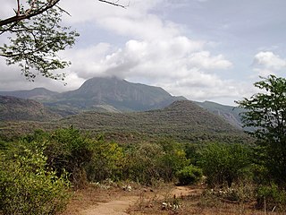
Chinnar Wildlife Sanctuary is located 18 km north of Marayoor on State Highway 17 in the Marayoor and Kanthalloor panchayats of Devikulam taluk in the Idukki district of Kerala state in South India. It is one of 18 wildlife sanctuaries among the protected areas of Kerala.

Kurinjimala Sanctuary protects the approximately 32 hectare core habitat of the endangered Neelakurinji plant in the Kottakamboor and Vattavada villages in Devikulam Taluk, in the Idukki district of Kerala, a state in southern India.

The Chinnar River originates in the Annaimalai Hills below a grassy pass between the hills Kumarikkal Mala (8,275 ft) and Kaladekatti Malai In Idukki District, Kerala state South India. The 18 km long Chinnar river defines the East-West Tamil Nadu/Kerala state boundary along the northern edge of the Chinnar Wildlife Sanctuary and the southern edge of the Indira Gandhi Wildlife Sanctuary. Several adult crocodiles were reported in the Chinnar river in 1992.
Kerala State Highway 17, also called the Northern outlet road and Munnar - Udumalpet road, is notable for passing between the Anaimalai Hills and the Palani Hills, through or near three important protected areas and providing opportunities for viewing wildlife in unspoiled forests.
The total road length is about 59.1 km (36.7 mi).

Albino gaur or white bison are a type of gaur, occasionally seen in the Manjampatti Valley, a 110.9 km2 (42.8 sq mi) protected area at the eastern end of Indira Gandhi Wildlife Sanctuary and National Park in Coimbatore District, Tamil Nadu, South India. They are occasionally called Manjampatti white bison. These gaur are notable for their distinctive ash-grey color as opposed to the almost black color of most gaur. Since 1929, there have been at least 19 documented sightings of these rare animals, including the 2004 photographs of N. A. Naseer.

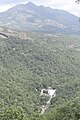
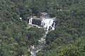
Thuvanam Waterfalls is located in the Chinnar Wildlife Sanctuary. The Thuvanam waterfalls is visible from the highway that connects Udumalpet and Marayoor.
Bhimgad Wildlife Sanctuary is a protected area in the Western Ghats, in Khanapur Taluk of Belgaum District near Jamboti Village, Karnataka state, India. This 19,042.58 ha (73.5238 sq mi) of Tropical and subtropical moist broadleaf forests forest area was long awaiting to be a wild life sanctuary and finally declared in December 2011.
Kumarikkal Mala is a peak situated in the Chinnar Wildlife Sanctuary in Kerala at an altitude of 2,522m above sea level. It is the highest peak in the Chinnar Wildlife Sanctuary and one of the highest peaks in Anamalai Hills exceeding 2,000m.