Kallanai Dam

Last updated

Kallanai Dam
Grand Anicut, Kallanai (11876067114).jpg
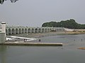
Kallanai Dam with its floodgates open
Location Thanjavur district, Tamil Nadu, India
Purpose Irrigation
StatusOperational
Construction beganc.150 CE
Built by Karikala cholan of Chola dynasty
Operator(s) Government of Tamil Nadu
Dam and spillways
Type of dam Barrage
Impounds River
Height (foundation)5.4 metres (18 ft)
Length329 metres (1,079 ft)
Width (base)20 metres (66 ft)

Kallanai (also known as the Grand Anicut) is an ancient dam built by Karikala of Chola dynasty in 150 CE. It is built (in running water) across the Kaveri river flowing from Tiruchirapalli District to Thanjavur district, Tamil Nadu, India. The dam is located in Thanjavur district, [1] [2] 15 km from Tiruchirapalli and 45 km from Thanjavur. [3] [4] [5] It is the fourth oldest water-diversion or water-regulator structure in the world and the oldest in India that is still in use. [6] [7] Because of its spectacular architecture, it is one of the prime tourist spots in Tamil Nadu.

Contents

History

The dam was originally built by King Karikalan of the Chola Dynasty in c.100 – c.150 CE. It is located on the river in Trichy district, exactly 14 km from the city of Tiruchirappalli and 45 km from the city of Thanjavur. The idea behind the construction of the dam was to divert the river to the delta districts thereby boosting irrigation. [3] [4] [5] This dam was re-modeled by the British during the 19th century. In 1804, Captain Caldwell, a military engineer, was appointed by the British to make a study on the Kaveri river and promote irrigation for the delta region. [8] He found that a large amount of water passed onto the Kollidam leaving behind a small volume for irrigation purposes. [8] Caldwell initially proposed a solution by raising the dam and hence raised the dam stones to a height of 69 centimetres (27 in), thus increasing the capacity of the dam. [3] Following this, Major Sim proposed the idea of undersluices across the river with outlets leading to the Kollidam River (Coleroon) thus preventing formation of silt. [3] The Lower Anaicut built by Sir Arthur Cotton in the 19th century across Coleroon, the major tributary of Cauvery is said to be a replicated structure of Kallanai. [3]

Geography

The Kaveri river splits into two at a point 20 miles (32 km) west of Kallanai. The two rivers form the island of Srirangam before joining at Kallanai. The northern channel is called the Kollidam (Coleroon); the other retains the name Kaveri, and empties into the Bay of Bengal at Poompuhar. On the seaward face of its delta are the seaports of Nagapattinam and Karaikal. [9]

Description

The purpose of the Kallanai was to divert the waters of the Kaveri across the fertile delta region for irrigation via canals and to its northern delta branch Kollidam/Coleroon. Downstream of the barrage, the river Kaveri splits into four streams known as Kollidam Aru, Kaveri, Vennaru and Puthu Aru. However, the flood waters can be allowed, by opening the barrage/anaicut gates, to pass through the other three delta branches also to join the sea. [10] It is constructed from unhewn stone spanning the Kaveri and is 329 m (1,079 ft) long, 20 m (66 ft) wide and 5.4 m (18 ft) high. [11] The dam is still in excellent condition, and supplied a model to later engineers, including Sir Arthur Cotton's 19th-century dam across the Kollidam, the major distributary of the Kaveri. [12] The area irrigated by the ancient irrigation network is about 69,000 acres (28,000  ha ). By the early 20th century, the irrigated area had been increased to about one million acres (400,000 ha). [13]

The delta farmers of Tamil Nadu have demanded the Tamil Nadu government to honor Karikala Cholan, who built this dam. [14]

See also

Related Research Articles

<span class="mw-page-title-main">Kaveri</span> River in southern India

The Kaveri is one of the major Indian rivers flowing through the states of Karnataka and Tamil Nadu. The Kaveri River rises at Talakaveri in the Brahmagiri range in the Western Ghats, Kodagu district of the state of Karnataka, at an elevation of 1,341 m above mean sea level and flows for about 800 km before its outfall into the Bay of Bengal. It reaches the sea in Poompuhar, in Mayiladuthurai district. It is the third largest river – after Godavari and Krishna – in southern India, and the largest in the state of Tamil Nadu, which, on its course, bisects the state into north and south. In ancient Tamil literature, the river was also called Ponni.

<span class="mw-page-title-main">Srirangam</span> Region of Tiruchirappalli, Tamil Nadu

Srirangam is a neighbourhood in the city of Tiruchirappalli in the Indian state of Tamil Nadu. A river island, Srirangam is bounded by the Kaveri River on one side and its distributary Kollidam on the other side. Considered as the first among the 108 Divya Desams, a group of Vishnu temples, it is famous for the Sri Ranganathaswamy Temple, the largest temple complex in India and the biggest functioning Hindu temple in the world. Srirangam is also home to a significant population of Sri Vaishnavas.

<span class="mw-page-title-main">Tiruchirappalli district</span> District of Tamil Nadu in India

Tiruchirappalli District is one of the 38 districts, located along the Kaveri River, in Tamil Nadu, India. The headquarters of the district is the city of Tiruchirappalli.

<span class="mw-page-title-main">Karikala</span> Historical Chola king who ruled over southern India

Karikala often referred to as Karikala the Great was a Tamil king of the Early Cholas of the Chola dynasty who ruled ancient Tamilakam from Uraiyur. He is credited with the construction of the flood banks of the river Kaveri. He is recognised as the greatest of the Early Cholas. In Thiruvalangadu plates of Rajendra Chola I, Medieval Tamil Cholas listed Karikala Chola as one of their ancestors. In Malepadu plates of Renati Chola king Punyakumara, Telugu Cholas claimed that they belong to the family of Karikala Chola and praises him for stopping the overflow over the banks of river Kaveri. Kakatiya king Ganapati-deva's Garavapadu charter traces the family's ancestry to Durjaya, a descendant of Karikala Chola who arrived at a town called Kakati during a hunting expedition, and set up his camp there.Many other Telugu dynasties also claimed descendant from Karikala Chola.

<span class="mw-page-title-main">Jayankondam</span> First Grade Municipality in Tamil Nadu, India

Jayankondam is a First Grade Municipality in Ariyalur district of Tamil Nadu in India. As of 2023, the town had a population of 46,000.

Koothappar is a panchayat town in Tiruchirappalli district in the Indian state of Tamil Nadu. It is located 16 km from Tiruchirappalli.

<span class="mw-page-title-main">Needamangalam</span> Town Panchayat in Tamil Nadu, India

Needamangalam (Nidamangalam) formerly Yamunambalpuram, is a town panchayat in Thiruvarur district in the Cauvery Delta of Indian state of Tamil Nadu. Needamangalam was originally part of the composite Tanjore Dist during British Raj until 1997 AD. In the 18th and 19th century, it was also called Yamunambalpuram. Needamangalam is the headquarters of the Needamangalam Taluk. The town is located 20 km east of Thanjavur, 80 km east of Tiruchirappalli and 318 km south of Chennai. Needamangalam is a junction for two busy highways, (i) National Highway 67 is a National Highway in Southern Indian states of Tamil Nadu and Karnataka that runs from Nagapattinam, a sea-side town in Tamil Nadu to Gundlupet, Karnataka (ii) State Highway SH-66 connecting Kumbakonam with Adirampattinam via Mannargudi in Cauvery Delta.

<span class="mw-page-title-main">Thirukattupalli</span> Panchayat Town in Tamil Nadu, India

Thirukattupalli is a panchayat town near Thiruvaiyaru in Thanjavur district in the Indian state of Tamil Nadu. The economy of this town is majorly based on the agricultural lands of the surrounding villages. Its nearby major cities include Thanjavur and Trichy. Modes of transportation to these cities include regular daily bus services and Budalur Railway Station. Sir P. S. Sivaswami Iyer Higher Secondary School located at the heart of this town serves as the alma-mater for nearly all locals.

Kailasapuram is a township located 13 km (8 mi) from Tiruchirapalli in Tamil Nadu, India. It contains the manufacturing and housing of Bharat Heavy Electricals Limited (BHEL) as part of BHEL's 3,000-acre (12 km2) Tiruchirapalli Complex.

<span class="mw-page-title-main">Valadi</span> Village in Tamil Nadu, India

Valadi is a zone in Trichy city located on 5 miles from Chathram Bus Terminus in Trichy, Tamil Nadu along the Trichy-Chennai railway. Its size and importance today is much lesser than its status in the pre-independence era, due to massive emigration over the last few decades in search for better career, and its diaspora numbering a few thousands is spread all across the world.

<span class="mw-page-title-main">Vennaaru River</span>

The Vennar River or Vennaaru is a river and distributary of the Kaveri River in the Kaveri delta. It flows through the Thanjavur, Tiruvarur, and Nagapattinam districts of Tamil Nadu, India.

<span class="mw-page-title-main">Thanjavur district</span> District in Tamil Nadu, India

Thanjavur district is one of the 38 districts of the state of Tamil Nadu, in southeastern India. Its headquarters is Thanjavur. The district is located in the delta of the Cauvery River and is mostly agrarian.

Uraiyur is a locality in Tiruchirapalli city in Tamil Nadu, India. Uraiyur was the ancient name of Tiruchirappalli City. Now, it became one of the busiest areas in Trichy City. It was the capital of the early Cholas, who were one of the three main kingdoms of the ancient Tamil country. Sometimes spelt as Urayur, this location is also known as Thirukkozhi, Nikalaapuri, Uranthai, and Kozhiyur or Koliyur.

Pettavaithalai is a panchayat town in Srirangam taluk Tiruchirappalli district in the Indian state of Tamil Nadu.

Anaikarai is a village panchayat under Thiruvidaimarudur Taluk in Tanjavur district, Tamil Nadu, India. Anaikarai connects with two major bridges. Nearly 1 km long on both sides. It is an island in the basin of Cauvery river. It is located at the distance of 260 km from Chennai and 25 km from Kumbakonam.

Srirangam Island is a river island in the city of Tiruchirappalli, in the Indian state of Tamil Nadu. The island is formed by the Kaveri and Kollidam Rivers.

<span class="mw-page-title-main">Upper Anaicut</span> Dam in Tamil Nadu, India

The Upper Anaicut, also known as Mukkombu is a dam built on the Kaveri River in the state of Tamil Nadu in southern India. The regulator dam was constructed between 1836 and 1838 by Sir Arthur Cotton, a British irrigation engineer who was inspired by the architectural beauty of Grand Anaicut canal built by Karikala Chola in Kallanai of Thanjavur district in the second century.

<span class="mw-page-title-main">Lower Anaicut</span> Dam in Tamil Nadu, India

The Lower Anaicut or Anaikkarai is a dam and bridge built on the Kollidam in the Indian state of Tamil Nadu.

<span class="mw-page-title-main">Kalathur</span> Village in Tamil Nadu, India

Kalathur is a panchayat village in Peravurani panchayat Union of Thanjavur district in the Indian state of Tamil Nadu. Kalathur is a part of the Pattukkottai taluk of Thanjavur district and located 67 kilometres (42 mi) south of Thanjavur connected via State Highway 29.

Grand Anicut Canal System or Puthu Aru or Kallanai Canal is a man made canal in Tamil Nadu, constructed as part of Cauvery-Mettur project during 1925–1934. British Engineer Colonel W M Ellis, who is also the architect of Mettur Dam, designed this canal on the request of C. P. Ramaswami Iyer, the Diwan of Travancore

References

  1. "Flowing waters for fertile fields". The Hindu. India. 29 August 2011.
  2. Singh, Vijay P.; Ram Narayan Yadava (2003). Water Resources System Operation: Proceedings of the International Conference on Water and Environment. Allied Publishers. p. 508. ISBN   81-7764-548-X.
  3. 1 2 3 4 5 Syed Muthahar Saqaf (10 March 2013). "A rock solid dam that has survived 2000 years". The Hindu . Retrieved 13 November 2013.
  4. 1 2 "Incredible India! A 2,000-year-old functional dam". India Today. 26 August 2013. Retrieved 15 February 2019.
  5. 1 2 "Karikalan cholan memorial inaugurated - Times of India". The Times of India. 13 February 2014. Retrieved 15 February 2019.
  6. Christopher V. Hill (2008). South Asia: An Environmental History. ABC-CLIO. pp. 33–. ISBN   978-1-85109-925-2.
  7. "Kallanai Dam || Thanjavur Tourism". www.thanjavurtourism.com. Retrieved 2 November 2018.
  8. 1 2 Skempton 2002, p. 114.
  9. Wiebe E. Bijker (19 September 2006). "Dikes and Dams, Thick with Politics". Maastricht University. Archived from the original on 25 April 2012. Retrieved 7 November 2011.
  10. "Grand Anicut A00677". WRIS, India. Retrieved 7 November 2016.
  11. "Places to visit". IIM-Trichy, India. Archived from the original on 19 December 2011. Retrieved 7 November 2011.
  12. Govindasamy Agoramoorthy; Sunitha chaudhary; Minna J. HSU. "The Check-Dam Route to Mitigate India's Water Shortages" (PDF). Law library — University of New Mexico. Archived from the original (PDF) on 20 July 2013. Retrieved 7 November 2011.
  13. "Fit case for World Heritage status". The Hindu . Trichy, India. 10 September 2007. Archived from the original on 14 September 2007.
  14. "CM's word on Karikalan memorial cheers farmers in Cauvery Delta". The New Indian Express. Retrieved 26 July 2023.

Bibliography

Further reading