Thanjavur district

Last updated

Thanjavur district
N-TN-C192 Sunrise-Perspective-of-BigTemple.jpg
Royal Palace, Thanjavur, 16th cent and later (6) (37498380391).jpg
Kumbeswarar temple 13.jpg
Athiyur1.jpg
Nickname: 
Rice Bowl of Tamil Nadu
Thanjavur in Tamil Nadu (India).svg
Location in Tamil Nadu
Coordinates: 10°47′8.16″N79°8′24.36″E / 10.7856000°N 79.1401000°E / 10.7856000; 79.1401000
Country Flag of India.svg  India
State TamilNadu Logo.svg Tamil Nadu
Municipal Corporations Thanjavur, Kumbakonam
Municipalities Pattukkottai, Adirampattinam
Largest city Thanjavur
Headquarters Thanjavur
Talukas
Budalur,
Kumbakonam,
Orathanadu,
Papanasam,
Pattukkottai,
Peravurani,
Thanjavur,
Thiruvaiyaru,
Thiruvidaimarudur,
Thiruvonam
Government
   District Collector Deepak jackob, IAS [1]
   Superintendent of Police Aashish Rawath, IPS [2]
Population
 (2011)
  Total2,405,890
Languages
  Official Tamil
Time zone UTC+5:30 (IST)
PIN
613xxx
Telephone code0436,0435
ISO 3166 code ISO 3166-2:IN
Vehicle registration TN-49, TN-68 [3]
Website thanjavur.nic.in

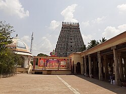
Thanjavur district is one of the 38 districts of the state of Tamil Nadu, in southeastern India. Its headquarters is Thanjavur (Tanjore) . The district is located in the delta of the Cauvery River and is mostly agrarian.

Contents

Geography

Agriculture - especially the cultivation of rice - is the main occupation of people in Thanjavur district. Paddy Fields Thanjavur.jpg
Agriculture – especially the cultivation of rice – is the main occupation of people in Thanjavur district.
The Brihadisvara Temple at Thanjavur Brihadeeswara.jpg
The Brihadisvara Temple at Thanjavur

The district is located at 10°05′N79°10′E / 10.08°N 79.16°E / 10.08; 79.16 in Central Tamil Nadu bounded on the northeast by Mayiladuthurai district, on the east by Tiruvarur District, on the south by the Palk Strait of Bay of Bengal on the west by Pudukkottai District and Tiruchirappalli, small border with Cuddalore on the northeast and on the north by the river Kollidam, across which lie part of Tiruchirappalli, and Ariyalur districts.

Demographics

Historical population
YearPop.±% p.a.
1901928,222    
1911978,651+0.53%
1921958,929−0.20%
1931986,308+0.28%
19411,059,583+0.72%
19511,228,360+1.49%
19611,317,920+0.71%
19711,592,998+1.91%
19811,848,132+1.50%
19912,053,760+1.06%
20012,216,138+0.76%
20112,405,890+0.82%
source: [4]
Religions in Thanjavur district (2011) [5]
ReligionPercent
Hinduism
86.28%
Islam
7.93%
Christianity
5.57%
Other or not stated
0.22%

According to the 2011 census, Thanjavur district had a population of 2,405,890 with a sex-ratio of 1,035 females for every 1,000 males, much above the national average of 929. 35.39% of the population lived in urban areas. [6] A total of 238,598 were under the age of six, constituting 121,949 males and 116,649 females. Scheduled Castes and Scheduled Tribes accounted for 18.91% and 0.15% of the population, respectively. The average literacy of the district was 74.44%, compared to the national average of 72.99%. [6] The district had a total of 605,363 households. There were a total of 974,079 workers, comprising 117,321 cultivators, 327,673 main agricultural labourers, 26,430 in house hold industries, 363,060 other workers, 139,595 marginal workers, 12,592 marginal cultivators, 87,688 marginal agricultural labourers, 4,770 marginal workers in household industries and 34,545 other marginal workers. [7]

Languages of Thanjavur district (2011) [8]

   Tamil (97.42%)
   Saurashtra (1.07%)
  Others (1.51%)

At the time of the 2011 census, 97.42% of the population spoke Tamil and 1.07% Saurashtra as their first language. [8]

Politics

Source: [9] [10]
DistrictNo.ConstituencyNamePartyAllianceRemarks
Thanjavur 170 Thiruvidaimarudur (SC) Go. Vi. Chezhiyan Dravida Munnetra Kazhagam SPA Chief Whip of the Government
171 Kumbakonam G. Anbazhagan Dravida Munnetra Kazhagam SPA
172 Papanasam Dr. M. H. Jawahirullah Dravida Munnetra Kazhagam (MMK) SPA
173 Thiruvaiyaru Durai Chandrasekaran Dravida Munnetra Kazhagam SPA
174 Thanjavur T. K. G. Neelamegam Dravida Munnetra Kazhagam SPA
175 Orathanadu R. Vaithilingam ADMKTUMK NDA
176 Pattukkottai K. Annadurai Dravida Munnetra Kazhagam SPA
177 Peravurani N. Ashok Kumar Dravida Munnetra Kazhagam SPA

Economy

Agriculture

Thanjavur district lies in the Kaveri delta, the most fertile region in the state. [11] The district is the main rice producing region in the state and hence known as the Rice Bowl of Tamil Nadu. [12] The Kaveri River and its tributaries irrigate the district. Apart from paddy, farmers here grow coconut and sugarcane and it is the largest producer of coconut in Tamil Nadu. Being an agrarian economy, industrial growth in the district is mainly confined to agro-based industries. Many rice mills and oil mills are spread over the district.[ citation needed ]

Tourism

Great Living Chola Temples of Thanjavur

Airavateswara Temple, in Darasuram, near Kumbakonam, Thanjavur district, was built by Rajaraja Chola II in the 12th century CE, and is a UNESCO World Heritage Site. Airavateswara Temple, Darasuram in Thanjavur District.jpg
Airavateswara Temple, in Darasuram, near Kumbakonam, Thanjavur district, was built by Rajaraja Chola II in the 12th century CE, and is a UNESCO World Heritage Site.

Thanjavur's Brihadisvara Temple (known also as Rajarajesvaram or Peruvudaiyār Kōvil), built by the Cholas and now a UNESCO World Heritage Site, is one of the largest of its kind and also one of the finest examples of classical Dravidian architecture in the world. Airavateswara Temple, in Darasuram, near Kumbakonam, has also been designated part of the same UNESCO World Heritage site and forms another major tourist attraction of the district. The green paddy fields of the Kaveri river valley provide a picturesque setting for these and other important ancient monuments of the district.

Prathyangira Devi Temple is also located in the district.

Manora Fort

The Manora Fort is situated 20 km (12 mi) away from Pattukkottai and 60 km (37 mi) from Thanjavur in the village of Mallipattinam. The fort was built by Maratha ruler Serfoji II in 1814–1815 to commemorate the successful advance of the British over Napoléon Bonaparte. Overlooking the Bay of Bengal, the fort is hexagonal structure and has eight storeys, raising to a height of 75 ft (23 m), tapering to its top. The tower is surrounded by a wall and a moat, resembling a fort. The monument looks like a pagoda, with arched windows, circular staircase and eaves separating one storey from the other.[ citation needed ]

Flora

The flora of Thanjavur was studied and documented in some detail by S. A. Ganapathy for a doctoral thesis in 1992. [13]

Cultural significance

Thanjavur is famous for the Saraswati veena (the national instrument), Thanjavur art plates, Thanjavur oil paintings and Thalaiyatti Bommai.

Notable people

See also

Notes and references

  1. district Collector
  2. City Superintendent of Police
  3. www.tn.gov.in
  4. Decadal Variation In Population Since 1901
  5. "Table C-01 Population by Religion: Tamil Nadu". censusindia.gov.in. Registrar General and Census Commissioner of India. 2011.
  6. 1 2 "Census Info 2011 Final population totals". Office of The Registrar General and Census Commissioner, Ministry of Home Affairs, Government of India. 2013. Retrieved 26 January 2014.
  7. "Census Info 2011 Final population totals – Thanjavur district". Office of The Registrar General and Census Commissioner, Ministry of Home Affairs, Government of India. 2013. Retrieved 26 January 2014.
  8. 1 2 "Table C-16 Population by Mother Tongue: Tamil Nadu". Census of India . Registrar General and Census Commissioner of India.
  9. "Tamil Nadu Election Results 2021: Here's full list of winners". CNBCTV18. 3 May 2021. Retrieved 22 December 2023.
  10. "Tamil Nadu Election Results 2021: Full list of winners". www.indiatvnews.com. 2 May 2021. Retrieved 22 December 2023.
  11. Nathan, K. K. (October 1995). "Assessment of Recent Droughts in Tamil Nadu" (PDF). Drought Network News. Archived from the original (PDF) on 17 March 2003.
  12. "Welcome to Thanjavur (District Official Website)". District Administration of Thanjavur. Archived from the original on 3 February 2006. Retrieved 22 January 2012.
  13. Ragupathy, Subramanyam (1992). Flora of Thanjavur District. Doctoral dissertation, PhD thesis. Madras, India: Centre for Advanced Study in Botany, University of Madras.
 
 
Largest cities or towns in Thanjavur district
Rank Taluk Pop.
Thanjavur - Brihadisvara Temple (56).jpg
Thanjavur
Cauvery Bridge Kumbakonam.jpg
Kumbakonam
1 Thanjavur Thanjavur taluk 290,724
2 Kumbakonam Kumbakonam taluk 140,156
3 Pattukkottai Pattukkottai taluk 73,135
4 Adiramapattinam Pattukkottai taluk 31,066
5 Peravurani Peravurani taluk 21,035
6 Papanasam Papanasam taluk 16,397
7 Madukkur Pattukkottai taluk 15,436
8 Thiruvaiyaru Thiruvaiyaru taluk 14,535
9 Vallam Thanjavur taluk 14,495
10 Ayyampettai (Thanjavur district) Papanasam taluk 14,202

Related Research Articles

<span class="mw-page-title-main">Kumbakonam</span> City Municipal corporation in Tamil Nadu, India

Kumbakonam, or Kudanthai, is a city municipal corporation in the Thanjavur district in the Indian state of Tamil Nadu. It is located 40 km (25 mi) from Thanjavur and 282 km (175 mi) from Chennai and is the headquarters of the Kumbakonam taluk of Thanjavur district. It is the second largest city in the district after Thanjavur. The city is bounded by two rivers, the Kaveri River to the north and Arasalar River to the south. Kumbakonam is known as a "Temple town" due to the prevalence of a number of temples here and is noted for its Mahamaham festival, which happens once in 12 years, attracting people from all over the country.

<span class="mw-page-title-main">Thanjavur</span> Historical city in Tamil Nadu, India

Thanjavur, also known as Thanjai, previously known as Tanjore, is a city in the Indian state of Tamil Nadu. It is the 11th biggest city in Tamil Nadu and biggest and most populous city in delta region. Thanjavur is an important center of southern Indian religion, art, and architecture. Most of the Great Living Chola Temples, which are UNESCO World Heritage Monuments, are located in and around Thanjavur. The foremost among these, the Brihadeeswara Temple, built by the Chola emperor Rajaraja I, is located in the centre of the city. This temple has one of the largest bull statue in India carved out of a single granite rock called Nandi. Thanjavur is also home to Tanjore painting, a painting style unique to the region. Thanjavur is the headquarters of the Thanjavur District. The city is an important agricultural centre located in the Kaveri Delta and is known as the Rice bowl of Tamil Nadu. Thanjavur is administered by a municipal corporation covering an area of 36.31 km2 (14.02 sq mi) and had a population of 222,943. Roadways are the major means of transportation, while the city also has railway connectivity. The nearest airport is Tiruchirapalli International Airport, located 59.6 km (37.0 mi) away from the city. The nearest seaport is Karaikal, which is 94 km (58 mi) away from Thanjavur. The city first rose to prominence during the reign of the Cholas when it served as the capital of the empire. After the fall of the Cholas, the city was ruled by various dynasties such as the Mutharaiyar dynasty, the Pandyas, the Vijayanagar Empire, the Madurai Nayaks, the Thanjavur Nayaks, the Thanjavur Marathas and the British Empire. It has been a part of independent India since 1947.

<span class="mw-page-title-main">Mayiladuthurai</span> Place in Tamil Nadu, India

Mayiladuthurai is a Municipality and district headquarter of Mayiladuthurai district in Tamil Nadu, India. The town is located at a distance of 256 km (159 mi) from the state capital, Chennai.

<span class="mw-page-title-main">Nagapattinam</span> Town in Tamil Nadu

Nagapattinam is a town in the Indian state of Tamil Nadu and the administrative headquarters of Nagapattinam district. The town came to prominence during the period of Medieval Cholas and served as their important port for commerce and east-bound naval expeditions. The Chudamani Vihara in Nagapattinam constructed by the Srivijayan king Sri Mara Vijayattungavarman of the Sailendra dynasty with the help of Rajaraja Chola I was an important Buddhist structure in those times. Nagapattinam was settled by the Portuguese and, later, the Dutch under whom it served as the capital of Dutch Coromandel from 1660 to 1781. In November 1781, the town was conquered by the British East India Company. It served as the capital of Tanjore district from 1799 to 1845 under Madras Presidency of the British. It continued to be a part of Thanjavur district in Independent India. In 1991, it was made the headquarters of the newly created Nagapattinam District. Nagapattinam is administered by a Special grade municipality covering an area of 17.92 km2 (6.92 sq mi) and had a population of 102,905 as of 2011.

<span class="mw-page-title-main">Mannargudi</span> Town in Tamil Nadu, India

Mannargudi is a town in Thiruvarur district in the Indian state of Tamil Nadu. It is the headquarters of the Mannargudi taluk. The town is located at a distance of 28 km (17 mi) from the district headquarters Thiruvarur, 36 km from Kumbakonam, 40 km from Thanjavur and 310 km (190 mi) from the state capital Chennai. Mannargudi is known for the Rajagopalaswamy temple, a prominent Vaishnavite shrine.

<span class="mw-page-title-main">Tenkasi</span> Municipality in Tamil Nadu, India

Tenkasi is a town and headquarters of the Tenkasi district in Indian state of Tamil Nadu.

<span class="mw-page-title-main">Ariyalur district</span> District in Tamil Nadu, India

Ariyalur district is an administrative district, one of the 38 districts in the state of Tamil Nadu in India. The district headquarters is located at Ariyalur. The district encompasses an area of 1,949.31 km².

<span class="mw-page-title-main">Thiruvarur</span> Special Grade Municipality in Tamil Nadu, India

Thiruvarur also spelt as Tiruvarur is a municipality in the Indian state of Tamil Nadu. It is the administrative headquarters of Thiruvarur district and Thiruvarur taluk. The temple chariot of the Thyagaraja temple, weighing 360 tonnes (790,000 lb) and measuring 96 feet (29 m) tall is the largest temple chariot in India. Thiruvarur is the birthplace of Tyagaraja, Muthuswami Dikshitar and Syama Sastri, popularly known as the Trinity of Carnatic music of the 18th century CE. Thiruvarur Thiyagarajaa Swaamy temple is older than Tanjore big temple.

<span class="mw-page-title-main">Palani</span> Town in Tamil Nadu, India

Palani (Tamil:[paɻani], is a town and a taluk headquarters in Dindigul district of the western part of Tamil Nadu state in India. It is located about 106 kilometres south-east of Coimbatore and 122 kilometres north-west of Madurai, 67 kilometres from Kodaikanal. The Palani Murugan Temple or Arulmigu Dhandayuthapani Swamy Temple, dedicated to Murugan is situated on a hill overlooking the town. The temple is visited by more than 7 million pilgrims each year. As of 2011, the town had a population of 292301 which makes it the second largest town in the district after Dindigul.

<span class="mw-page-title-main">Tiruchirappalli district</span> District of Tamil Nadu in India

Tiruchirappalli District is one of the 38 districts, located along the Kaveri River, in Tamil Nadu, India. The headquarters of the district is the city of Tiruchirappalli.

<span class="mw-page-title-main">Karur district</span> District of Tamil Nadu in India

Karur District is one of the 38 districts in the Indian state of Tamil Nadu. The main town in Karur District is the city of Karur, which is also the district headquarters. The district has a population of 1,064,493 with a sex-ratio of 1,015 females for every 1,000 males, according to 2011 census.

<span class="mw-page-title-main">Nagapattinam district</span> District of Tamil Nadu in India

Nagapattinam district is one of the 38 districts of Tamil Nadu state in southern India. Nagapattinam district was carved out by bifurcating the erstwhile composite Thanjavur district on 19 October 1991. The town of Nagapattinam is the district headquarters.

<span class="mw-page-title-main">Pudukkottai district</span> District in Tamil Nadu, India

Pudukkottai District is one of the 38 districts of Tamil Nadu state in southern India. The city of Pudukkottai is the district headquarters. It is also known colloquially as Pudhugai.

<span class="mw-page-title-main">Oddanchatram</span> Town in Tamil Nadu, India

Oddanchatram is a town in Dindigul district in the Indian state of Tamil Nadu. Oddanchatram is a region in the southwest of Tamil Nadu. The Town was carved out of Madurai District in 1985. Oddanchatram is also famous for vegetable and cattle market. As of 2011, the town had a population of 30,064. It is known as vegetable city of Tamil Nadu. Oddanchatram vegetable market is the largest supplying of vegetables in Tamilnadu and Kerala. Agriculture is the major economic support for the town.

<span class="mw-page-title-main">Jayankondam</span> First Grade Municipality in Tamil Nadu, India

Jayankondam is a First Grade Municipality in Ariyalur district of Tamil Nadu in India. As of 2023, the town had a population of 46,000.

<span class="mw-page-title-main">Papanasam</span> Panchayat Town/Sub urban in Tamil Nadu, India

Papanasam is a panchayat town in Thanjavur district in the Indian state of Tamil Nadu. It is located 25 kilometres (16 mi) from Thanjavur and 15 kilometres (9.3 mi) from Kumbakonam. The name literally translates to "Destruction of Sins" in the Tamil language. It is the suburban region of Kumbakonam.

<span class="mw-page-title-main">Pattukkottai</span> City in Tamil Nadu, India

Pattukkottai is a major town in Thanjavur district in the Indian state of Tamil Nadu and also important town in Delta districts and Commercial town of Thanjavur, Thiruvarur and Pudukkottai district Coastal areas. The town came to prominence throughout Southern India after the construction of the fort by Vanaji Pandithar, a feudatory of the Thanjavur Maratha ruler Shahuji I in 1686–87. The recorded history of Pattukkottai is known from the 17th century and has been ruled, at different times, by the Thanjavur Marathas and the British. It is the headquarters of the Pattukkottai taluk of Thanjavur district and is one of the two municipalities in the district.

<span class="mw-page-title-main">Thiruthuraipoondi</span> Town in Tamil Nadu, India

Thiruthuraipoondi is a municipality in Tiruvarur district in the Indian state of Tamil Nadu. Thiruthuraipoondi is an agricultural town located south of Thiruvarur district. The town is located at a distance of 28 km from the district headquarters Thiruvarur.

<span class="mw-page-title-main">Ariyalur</span> Town in Tamil Nadu, India

Ariyalur is a town and district headquarters of Ariyalur district in the South Indian state of Tamil Nadu and is rich in limestone, surrounded with seven cement factories and two sugar factories. The town is located at a distance of 310 km (190 mi) from the state capital Chennai.

<span class="mw-page-title-main">Viluppuram district</span> District of Tamil Nadu in India

Viluppuram, Villupuram or Vizhuppuram is one of the 38 districts that make up the state of Tamil Nadu, India. It was founded on 30 September 1993, prior to which it was part of the Cuddalore district. Vizhuppuram district lies in the way of the national highway connecting Tiruchirappalli and Chennai, and contains historical landmarks like the 500 year-old Gingee Fort.