
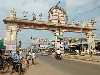
Thanjavur, also known as Thanjai, previously known as Tanjore, is a city in the Indian state of Tamil Nadu. It is the 11th biggest city in Tamil Nadu and biggest and most populous city in delta region. Thanjavur is an important center of southern Indian religion, art, and architecture. Most of the Great Living Chola Temples, which are UNESCO World Heritage Monuments, are located in and around Thanjavur. The foremost among these, the Brihadeeswara Temple, built by the Chola emperor Rajaraja I, is located in the centre of the city. This temple has one of the largest bull statue in India carved out of a single granite rock called Nandi. Thanjavur is also home to Tanjore painting, a painting style unique to the region. Thanjavur is the headquarters of the Thanjavur District. The city is an important agricultural centre located in the Kaveri Delta and is known as the Rice bowl of Tamil Nadu. Thanjavur is administered by a municipal corporation covering an area of 36.31 km2 (14.02 sq mi) and had a population of 222,943. Roadways are the major means of transportation, while the city also has railway connectivity. The nearest airport is Tiruchirapalli International Airport, located 59.6 km (37.0 mi) away from the city. The nearest seaport is Karaikal, which is 94 km (58 mi) away from Thanjavur. The city first rose to prominence during the reign of the Cholas when it served as the capital of the empire. After the fall of the Cholas, the city was ruled by various dynasties such as the Mutharaiyar dynasty, the Pandyas, the Vijayanagar Empire, the Madurai Nayaks, the Thanjavur Nayaks, the Thanjavur Marathas and the British Empire. It has been a part of independent India since 1947.

Thiruvaiyaru is a panchayat town in Thanjavur District in the Indian state of Tamil Nadu.
Panruti is a town, municipality and taluk headquarters of Cuddalore district, Tamil Nadu, India. Panruti is located between Cuddalore and Neyveli. Panruti is famous for jackfruits and cashew nuts. The jackfruit grown here is exported worldwide and is very sweet. It is a business capital of Cuddalore district. Kananchavadi one of the villages in panruti taluk, famous for palm juice. It has been a great commercial area for more than 200 years. The name Panruti came from the Tamil words "Pann" and "Urutti" meaning "composing song and music", as the place is where many saints and great religious singers such as nayanmars and vainavas sung. A 150-year-old government school was built here by the British East India Company and a more-than-1000-year-old temple Veerattaneswarar temple is nearby in Thiruvathigai. As of 2011, the town had a population of 60,323.

Aravakurichi is a panchayat town and a Taluk headquarters in Karur district in the state of Tamil Nadu, India. Aravakurichi is well known in Tamil Nadu as a major market for Moringa oleifera vegetable. Aravakurichi is the headquarters of Aravakurichi taluk which consists of 40 revenue Villages.
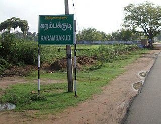
Karambakkudi is a panchayat town as well as Taluk in Pudukkottai district in the Indian state of Tamil Nadu. Karambakkudi is located about 40 km from Thanjavur and 40 km from Pudukkottai. This town is located on the border of the Thanjavur and Pudukkottai district in Tamil Nadu. The opinion of the people of this area is that this area should become an assembly constituency very soon, Here all higher secondary schools and Art's college is there.This area is covered by Delta Region.

Madambakkam is a neighborhood in the city of Tambaram, situated within the Chennai Metropolitan Area, Tamil Nadu, India.

Needamangalam (Nidamangalam) formerly Yamunambalpuram, is a town panchayat in Thiruvarur district in the Cauvery Delta of Indian state of Tamil Nadu. Needamangalam was originally part of the composite Tanjore Dist during British Raj until 1997 AD. In the 18th and 19th century, it was also called Yamunambalpuram. Needamangalam is the headquarters of the Needamangalam Taluk. The town is located 20 km east of Thanjavur, 80 km east of Tiruchirappalli and 318 km south of Chennai. Needamangalam is a junction for two busy highways, (i) National Highway 67 is a National Highway in Southern Indian states of Tamil Nadu and Karnataka that runs from Nagapattinam, a sea-side town in Tamil Nadu to Gundlupet, Karnataka (ii) State Highway SH-66 connecting Kumbakonam with Adirampattinam via Mannargudi in Cauvery Delta.
Thirukattupalli is a panchayat town near Thiruvaiyaru in Thanjavur district in the Indian state of Tamil Nadu. The economy of this town is majorly based on the agricultural lands of the surrounding villages. Its nearby major cities include Thanjavur and Trichy. Modes of transportation to these cities include regular daily bus services and Budalur Railway Station. Sir P. S. Sivaswami Iyer Higher Secondary School located at the heart of this town serves as the alma-mater for nearly all locals.

Thiruthuraipoondi is a municipality in Tiruvarur district in the Indian state of Tamil Nadu. Thiruthuraipoondi is an agricultural town located south of Thiruvarur district. The town is located at a distance of 28 km from the district headquarters Thiruvarur.
Thamaraipalayam is a village located on the west from banks of the Cauvery, in Erode district, Tamil Nadu, India.
Vadaseri South is a major village in the Orathanadu taluk of Thanjavur district in the Indian state of Tamil Nadu. Vadaseri comes under the Orathanadu constituency which elects a member to the Tamil Nadu Legislative Assembly once every five years and it is a part of the Thanjavur which elects its Member of Parliament (MP) once in five years. The village is administered by the Vadaseri panchayat, which covers an area of 12.2826 km2 (4.7423 sq mi). As of 2011, the village had a population of 4,810. The village is a part of the fertile Cauvery delta region and agriculture is the major occupation. Roadways and railways are the major mode of transportation to Vadaseri, the nearest railway stations are Mannargudi and Pattukkottai and the nearest international airport is Tiruchirapalli Airport, located 100 km (62 mi) away from the village, in the city of Tiruchirappalli.
Udayalur is a village in the Kumbakonam taluk of Thanjavur district, Tamil Nadu, India. Udayalur is a few kilometers away from the historic Chola dynasty stronghold town of Kizha Pazhayarai. The village was historically called SriKangeyapuram.
Thuthur is a village in the Ariyalur taluk of Ariyalur district, Tamil Nadu, India.
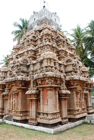
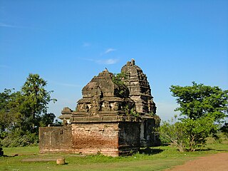
Tirupullamangai or Thirupullamangai is a Hindu temple dedicated to Lord Siva located in Pasupathikoil, Papanasam taluk of Thanjavur district, Tamil Nadu, India. It is one of the shrines of the 275 Paadal Petra Sthalams - Shiva Sthalams glorified in the early medieval Tevaram poems by Tamil Saivite Nayanar Tirugnanasambandar.
Vedal, pronounced as Vaedaal is a village in the Cheyyur taluk of the Chengalpattu district of Tamil Nadu, India. It is located 105 kilometres (65 mi) away from Chennai and 45 kilometres (28 mi) away from Pondicherry on the Tamil Nadu East Coast Road ECR. Vedal is situated about 10 kilometres (6.2 mi) far from the Bay of Bengal coast.
Maruthuvakudi, also known as Aduthurai is a small panchayat town situated near Kumbakonam,in the Thanjavur District in the Indian state of Tamil Nadu. It is the sub urban region of business city of Kumbakonam.

Cheyyur, is a town in Chengalpattu district in the Indian state of Tamil Nadu. Cheyyur is surrounded by four sub-areas: North, East, South and West Cheyyur. The town has a Taluk Office and a regional treasury centre. It is the administrative capital of the taluka of Cheyyur and it is the seat of the Member of Legislative assembly of Cheyyur Constituency in Tamil Nadu State. Cheyyur also host the District Munsif-cum-Judicial Magistrate Court. Cheyyur also is supported by the Fire and Rescue Station and a Police Station under the Superindent of Police, Chengalpattu. There is a taluka government hospital and a veterinary hospital available in the town.
Rajagiri is a panchayat village in the Papanasam taluk of Thanjavur district, Tamil Nadu, India.
Sadayarkovil is a village in Orathanadu Taluk in the state of Tamil Nadu, India. It is located 15 km away from Thanjavur city, and is connected to the city via the Thanjavur-Mannarkudi highway.
Kandiyur, also referred to as Thirukkandiyur, is a village in the Thiruvaiyaru taluk of Thanjavur district, Tamil Nadu. Kandiyur is 3.7 km away from the block's headquarters and Thiruvaiyaru, a sacred place. The village is centered around Kandeeswarar temple, after which it is named.

