Chennai district

Last updated

Chennai District
Madras
Chennai - bird's-eye view.jpg
View of Marina Beach
Nicknames: 
Chennai in Tamil Nadu (India).svg
Location in Tamil Nadu
Coordinates: 13°5′2″N80°16′12″E / 13.08389°N 80.27000°E / 13.08389; 80.27000
Country Flag of India.svg  India
State TamilNadu Logo.svg Tamil Nadu
Region Chola Nadu
Headquarters Chennai
Talukas Alandur, Aminjikarai, Ambattur, Ayanavaram, Egmore, Guindy, Madhavaram, Manali, Maduravoyal, Mylapore, Mambalam, Purasawalkam, Perambur, Shollinganallur, Thiruvottiyur, Tondiarpet, Velachery
Government
   District Collector Tmt.S.Amirtha Jothi, IAS
  Commissioner of Police Greater ChennaiShankar Jiwal, IPS
Area
[3]
  Total426 km2 (164 sq mi)
Elevation
6.7 m (22.0 ft)
Population
 (2011) [4]
  Total6,748,026
  Density16,000/km2 (41,000/sq mi)
Demonym(s) Chennaiite
Chennaikaran
Languages
  Official Tamil
Time zone UTC+5:30 (IST)
PIN
600XXX
Telephone code44
ISO 3166 code 044
Vehicle registration TN01
To
TN10
TN13
TN14
TN18
TN22
Sex ratio 951 female / 1000 male [5]
Literacy90.33% [5]
Website https://chennai.nic.in/

Chennai district, formerly known as Madras district, [lower-alpha 1] is one of the 38 districts in the state of Tamil Nadu, India. It is the smallest and the most densely populated district in the state. The district is coterminous with the city of Chennai, which is administered by the Greater Chennai Corporation. It is surrounded by Tiruvallur district in the north and the west, Kanchipuram district in the south-west, Chenglpattu district in the south, and the Bay of Bengal in the east.

Contents

As of 2011, the district had a population of 67,48,026 with a sex-ratio of 989 females for every 1,000 males. [5] Much of the district's population descended from its settlements in the 1st century CE to the Middle Ages, but the diversity has grown much since then. The district consists of only one civic body, the megacity of Chennai, which forms the core and the most notable portion of the much bigger Chennai metropolis, or officially, the Chennai Metropolitan Area. In 2018, the district's limits were expanded, aligning with that of the newly expanded Greater Chennai Corporation, which had annexed adjacent municipalities. It resulted in the area being increased from 175 square kilometres (68 sq mi) to 426 square kilometres (164 sq mi). [3] [6] The district is divided into three revenue divisions and ten taluks.
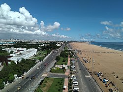
Etymology

The name Chennai was derived from Damarla Chennappa Nayak, the father of a general of the Vijayanagar Empire. [7]

Geography

Chennai district covers an area of 426 km2 located on the Eastern Coastal Plains of India. It is situated on the northeastern corner of Tamil Nadu along the Coramandel coast, a region bounded by the Bay of Bengal and is surrounded inland by the districts of Tiruvallur, Kanchipuram and Chengalpattu. It lies between 12°59' and 13°9' of the northern latitude and 80°12' and 80°19' of the eastern longitude at an average altitude of 6 metres above sea level on a 'sandy shelving breaker swept' beach. Terrain slope varies from 1:5000 to 1:10,000. [8] The terrain is very flat with contours ranging from 2 m to 10 m above mean sea level with a few isolated hillocks in the southwest beyond the district limits at St. Thomas Mount, Pallavaram and Tambaram. [9]

The district runs inland in a rugged semi-circular fashion and its coastline is about 25.60 km (2.5% of the total coastline of Tamil Nadu). Because of its strategic location and economic importance, it is referred to as the "Gateway of South India." The drainage system includes two rivers, namely, Cooum (flowing in the northern part) and Adyar (flowing in the southern part), a canal (the Buckingham), and a stream (the Otteri Nullah) slicing the district into several islands.

The district falls under Seismic Zone III indicating a moderate risk of earthquake. Geologically the district is divided into three regions, namely, sandy, clayey and hard-rock regions. The soil comprises clay, shale and sandstone. [10]

Of the total land area, reserved forests cover 2.71 km2 and is concentrated in and around the Guindy National Park region, one of the few national parks in the world located within a city. The forest cover of the district is as follows: [11]

ClassArea (Ha)Percentage
Dense forest151.011.16
Moderate dense TOF121.160.93
Non-forest12,215.5694.06
Open forest114.240.88
Open TOF153.731.18
Water231.461.78
Total12,987.16100

Climate

Chennai has Tropical savanna climate (Köppen: Aw)

Climate data for Chennai, India
MonthJanFebMarAprMayJunJulAugSepOctNovDecYear
Record high °C (°F)33
(91)
37
(99)
39
(102)
43
(109)
45
(113)
43
(109)
41
(106)
40
(104)
39
(102)
39
(102)
34
(93)
33
(91)
45
(113)
Mean daily maximum °C (°F)29
(84)
31
(88)
33
(91)
35
(95)
38
(100)
38
(100)
36
(97)
35
(95)
34
(93)
32
(90)
29
(84)
29
(84)
33
(92)
Mean daily minimum °C (°F)19
(66)
20
(68)
22
(72)
26
(79)
28
(82)
27
(81)
26
(79)
26
(79)
25
(77)
24
(75)
22
(72)
21
(70)
24
(75)
Record low °C (°F)14
(57)
15
(59)
17
(63)
20
(68)
21
(70)
21
(70)
22
(72)
21
(70)
21
(70)
17
(63)
15
(59)
14
(57)
14
(57)
Average precipitation mm (inches)16.2
(0.64)
3.7
(0.15)
3.0
(0.12)
13.6
(0.54)
48.9
(1.93)
53.7
(2.11)
97.8
(3.85)
149.7
(5.89)
109.1
(4.30)
282.7
(11.13)
350.3
(13.79)
138.2
(5.44)
1,266.9
(49.88)
Source: Indian Meteorological Department [12]

Demographics

According to 2011 census, Chennai district had a population of 4,646,732 in unexpanded old limits area of 176 sq.km. with a sex-ratio of 989 females for every 1,000 males, much above the national average of 929. Scheduled Castes and Scheduled Tribes accounted for 16.78% and 0.22% of the population respectively. The average literacy of the district was 81.27%, compared to the national average of 72.99%. [5] With the expanded limits to 426 sq. km. Chennai district had a population of 6,748,026 as per 2011 census data. [4]

The district had a total of 1,154,982 households. There were a total of 1,817,297 workers, comprising 10,210 cultivators, 10,251 main agricultural labourers, 29,143 in house hold industries, 1,569,950 other workers, 197,743 marginal workers, 4,244 marginal cultivators, 3,423 marginal agricultural labourers, 8,202 marginal workers in household industries and 181,874 other marginal workers. [13]

Religion

Religion in Chennai district (2011)
ReligionPercent
Hinduism
80.73%
Islam
9.45%
Christianity
7.72%
Jainism
1.11%
Other or not stated
0.93%

Administration and politics

Divisions of Chennai district. Chennai District.png
Divisions of Chennai district.

In 2013, five taluks on the district were split to create five new ones: Velachery, Purasawalkam, Ayanavaram, Aminjikarai and Guindy. [14]

In January 2018, the state government announced that the district will be expanded to match the boundaries of the Greater Chennai Corporation. This will integrate six additional taluks from Tiruvallur and Kanchipuram districts into the Chennai district. The new divisions and taluks of the district will be: [3] [6]

Revenue divisions and taluks

Members of Parliament

PC No.ConstituencyPolitical
Party
Elected
Representative
1 Chennai North DMK V. Kalanithi Veerasamy
2 Chennai South DMK T. Thamizhachi Thangapandian
3 Chennai Central DMK M. Dhayanithi Maaran
4 Sriperumbudur (partially) DMK T.R.Baalu

Politics

DistrictNo.ConstituencyNamePartyAllianceRemarks
Chennai 7 Maduravoyal K. Ganapathy Dravida Munnetra Kazhagam SPA
8 Ambattur Joseph Samuel Dravida Munnetra Kazhagam SPA
9 Madavaram S. Sudharsanam Dravida Munnetra Kazhagam SPA
10 Thiruvottiyur K. P. Shankar Dravida Munnetra Kazhagam SPA
11 Dr. Radhakrishnan Nagar J. J. Ebenezer Dravida Munnetra Kazhagam SPA
12 Perambur R. D. Shekar Dravida Munnetra Kazhagam SPA
13 Kolathur M. K. Stalin Dravida Munnetra Kazhagam SPA Chief Minister
14 Villivakkam A. Vetriazhagan Dravida Munnetra Kazhagam SPA
15 Thiru-Vi-Ka-Nagar (SC) P. Sivakumar (A) Thayagam Kavi Dravida Munnetra Kazhagam SPA
16 Egmore (SC) I. Paranthamen Dravida Munnetra Kazhagam SPA
17 Royapuram Idream R. Murthy Dravida Munnetra Kazhagam SPA
18 Harbour P. K. Sekar Babu Dravida Munnetra Kazhagam SPA
19 Chepauk-Thiruvallikeni Udhayanidhi Stalin Dravida Munnetra Kazhagam SPA
20 Thousand Lights Dr. Ezhilan Naganathan Dravida Munnetra Kazhagam SPA
21 Anna Nagar M. K. Mohan Dravida Munnetra Kazhagam SPA
22 Virugampakkam A. M. V. Prabhakara Raja Dravida Munnetra Kazhagam SPA
23 Saidapet M. Subramanian Dravida Munnetra Kazhagam SPA
24 Thiyagaraya Nagar J. Karunanithi Dravida Munnetra Kazhagam SPA
25 Mylapore Dha. Velu Dravida Munnetra Kazhagam SPA
26 Velachery J. M. H. Aassan Maulaana Indian National Congress SPA
27 Shozhinganallur S. Aravind Ramesh Dravida Munnetra Kazhagam SPA
28 Alandur T. M. Anbarasan Dravida Munnetra Kazhagam SPA

See also

Notes

  1. Both of these terms are also often used as metonyms for the Chennai metropolitan area's trading and financial services industries, which continue a notable history of being largely based in the city. The name Chennai is colloquially used for a far wider area than just the city. Chennai most often denotes the sprawling Chennai metropolis, including parts from the three districts of Tamil Nadu adjacent to the city/district of Chennai itself. This wider usage of Chennai is documented as far back as 1639, when the Madras Municipal Corporation was created.

Related Research Articles

<span class="mw-page-title-main">Kanchipuram district</span> District of Tamil Nadu in India

Kanchipuram district is one of the 38 districts in the state of Tamil Nadu in India. The area comprising the present day Kancheepuram district was earlier a part of Chingleput district. The original Chingleput district was split in 1997 into form the present day Kanchiepuram and Tiruvallur districts.

Tiruvallur district, also spelled as Thiruvallur district, is one of the 38 districts in the Indian state of Tamil Nadu. The fast developing city of Tiruvallur is the district headquarters. The district has a mixture of urban and rural characteristics. The eastern part of Tiruvallur district is dominated by urban characteristics while the Northern part of the district has influence of Andhra culture due to its position. In 2011, the district had a population of 3,728,104 with a sex-ratio of 987 females for every 1,000 males.

Ambattur is a northwestern neighbourhood of Chennai, India. It is located in Ambattur taluk of the Chennai District, surrounded by Avadi, Anna Nagar, Padi, Mogappair, Kallikuppam, Surapet, Korattur, Ayappakkam, Athipet and Thiruverkadu. It covers an area of 45 km2 (17 sq mi). The neighbourhood is served by Ambattur railway station of the Chennai Suburban Railway. Ambattur has its origins in a village of the same name which can be located at present as areas opposite to Ambattur telephone exchange. Ambattur was a village with large extents of agricultural farm lands irrigated by the once-sprawling Ambattur Lake. In 2011, the neighborhood had a population 466,205.

<span class="mw-page-title-main">Poonamallee</span> Suburb of Chennai, India

Poonamallee is a town and suburb of Chennai, India under the Chennai Metropolitan Area. It was historically called Pushpagirimangalam, later renamed in Tamil as Poovirundhavalli, and now colloquially called as Poondhamalli. It is the headquarters of the Poonamallee taluk of the Tiruvallur district in the Indian state of Tamil Nadu. The nearest Railway station is at Avadi. It acts as the gateway to the city from its western side. It is a town with rich cultural heritage and also a fast-growing areas in the city. As of 2011, the town had a population of 57,224. There are plans to merge the areas under Poonamallee Municipality with Avadi Municipal Corporation.

<span class="mw-page-title-main">Tiruttani</span> Town in Tamil Nadu, India

Tiruttani is a town in the Tiruvallur district, a suburb of Chennai within the Chennai Metropolitan Area, located in the state of Tamil Nadu, India. The town is renowned for the Tiruttani Murugan Temple, which is one of the Arupadaiveedu and is dedicated to Kartikeya (Murugan). Tiruttani was added to the Chennai Metropolitan Area in October 2022.

Thiruverkadu is a Western suburb of Chennai, Tamil Nadu. It comes under Thiruvallur district administration. It is famous for its Devi Karumariamman Temple. There is also Vedapureeswarar Temple in Thiruverkadu, where Lord Shiva and Goddess Parvathi are seen in their wedding pose inside the sanctum sanctorum. As of 2011, the town had a population of 62,289. It is a town with rich cultural heritage and also a fast-growing areas in the city.

Madhavaram is a neighbourhood of Chennai, Tamil Nadu, India. Located in the northern part of Chennai, it is also a taluk in Chennai District and a zone in Greater Chennai Corporation. It is located in between Perambur and Kodungaiyur. As of 2011, the neighbourhood had a population of 119,105. The Chennai district was expanded on 16 August 2018 by transferring Madhavaram taluk from Tiruvallur district to Chennai district.

<span class="mw-page-title-main">Chennai Metropolitan Development Authority</span> State agency of Tamil Nadu

The Chennai Metropolitan Development Authority (CMDA), formerly known as the Madras Metropolitan Development Authority (MMDA), is the nodal planning agency of Chennai in the Indian state of Tamil Nadu. The CMDA administers the Chennai Metropolitan Region, spread over an area of 5,904 km2 (2,280 sq mi) and covers the districts of Chennai, Thiruvallur, Chengalpattu, Ranipet and Kancheepuram. It was set up for the purposes of planning, co-ordination, supervising, promoting and securing the planned development of the Chennai Metropolitan Area. It coordinates the development activities of the municipal corporations, municipalities and other local authorities.

<span class="mw-page-title-main">Geography of Chennai</span> Capital city of Tamil Nadu, India

Chennai is located at 13.04°N 80.17°E on the southeast coast of India and in the northeast corner of Tamil Nadu. It is located on a flat coastal plain known as the Eastern Coastal Plains. The city has an average elevation of 6 metres (20 ft), its highest point being 60 m (200 ft). Chennai is 2,184 kilometres south of Delhi, 1,337 kilometres southeast of Mumbai, and 1,679 kilometers southwest of Kolkata by road.

Ambattur taluk is a taluk of Chennai district of the Indian state of Tamil Nadu. Its headquarters are the neighbourhood of Ambattur. This taluk was created from a division of Ponneri taluk, Tiruvallur district. On 4 January 2018, Chennai district was expanded by annexing Ambattur taluk. The RTO code for Ambattur taluk is TN-13.

  1. Ambattur
  2. Athipet
  3. Karukku
  4. Kallikuppam
  5. Pudur
  6. Korattur
  7. Menambedu
  8. Anna Nagar West extension
  9. Mogappair
  10. Oragadam
  11. Padi
  12. Pattravakkam.
<span class="mw-page-title-main">Chingleput District (Madras Presidency)</span> District in the Madras Presidency of British India

Chingleput district was a district in the Madras Presidency of British India. It covered the area of the present-day districts of Kanchipuram, Chengalpattu and Tiruvallur and parts of Chennai city. It was sub-divided into six taluks with a total area of 7,970 square kilometres (3,079 sq mi). The first capital was the town of Karunguzhi, with an interruption between 1825 and 1835, administrative headquarters were transferred to Kanchipuram. In 1859, the capital Saidapet, now a neighbourhood in the city of Chennai, was made the administrative headquarters of the district.

<span class="mw-page-title-main">Tiruvannamalai district</span> District of Tamil Nadu in India

Tiruvannamalai district is the largest and one of the 38 districts in the state of Tamil Nadu, in South India. It was formed in the year 1989 through the bifurcation of North Arcot into the Tiruvannamalai Sambuvarayar and Vellore Ambedkar districts. The city of Tiruvannamalai is the district headquarters.

Madhavaram taluk is a taluk of Chennai district in the Indian state of Tamil Nadu. The centre of the taluk is the neighbourhood of Madhavaram. The headquarters of the taluk is Tondiarpet division. And the taluk has been bifurcated from Ambattur taluk and on 2018 it has been annexed to Chennai district from tiruvallur by expanding Chennai city. And the taluk Has regions of Kathirvedu, Lakshmipuram, Madhavaram, Madhavaram Milk Colony, Mathur, Ponniammanmedu, Puthagaram, Puzhal, Surapet, Redhills, and the RTO of the taluk is TN 05.

Central Chennai is the part of Chennai city between the Coovum River and the Adyar River. While mostly grouped under South Chennai, Central Chennai is a term which has gained currency in recent times due to the rapid expansion of the city southwards. Covering the eastern neighbourhoods of Royapettah, Chepauk, Teynampet, Alwarpet, Mylapore, Triplicane and Mandaveli and the western neighbourhoods of Nungambakkam, Kodambakkam, Vadapalani, Virugambakkam, Valasaravakkam, Mambalam, T. Nagar, Nandanam and Saidapet, Central Chennai is largely upper class-upper middle class. The eastern part is largely upper class with two of the costliest pieces of real estate - the Boat Club Road and Poes Garden being located here while the western part is mainly middle class. Kodambakkam is the location of the Tamil film industry or Kollywood.

Tiruvottiyur taluk is a taluk of the city district of Chennai in the Indian state of Tamil Nadu. The centre of the taluk is the neighbourhood of Tiruvottiyur. The headquarters of the taluk is Tondiarpet division.

Ambattur division is a revenue division in the Chennai district of Tamil Nadu, India. It comprises the taluks of Ambattur, Aminjikarai, Ayanavaram, Egmore, Maduravoyal and Mambalam.

Kadambathur, also spelt Kadambattur, is a town located in Tiruvallur district in the Indian state of Tamil Nadu. It is a census town in Tiruvallur taluk. According to the 2011 census, the town has a population of 11,235.

Guindy division is a revenue division in the Chennai district of Tamil Nadu, India. It comprises the taluks of Alandur, Guindy, Mylapore, Sholinganallur and Velachery.

References

  1. "Chennai has emerged as India's Detroit". Deccan Herald. Retrieved 7 June 2017.
  2. "India Is Becoming A Hub For 'Medical Tourists' — Despite The 'Million Dollar Difference' In Care". Business Insider. 12 June 2014. Retrieved 21 March 2017.
  3. 1 2 3 Dennis S. Jesudasan (5 January 2018). "Chennai district doubles in size". The Hindu. Retrieved 23 November 2019.
  4. 1 2 "Chennai District | Government of Tamil Nadu | Gateway of South India | India".
  5. 1 2 3 4 "District Census Handbook Chennai, Part XII - B" (PDF). Census of India 2011. 16 June 2014.
  6. 1 2 Yogesh, Kabirdoss (19 January 2018). "Chennai district boundaries likely to be redrawn on April 1". The Times of India. Retrieved 23 November 2019.
  7. "District Profile, Chennai". Government of Tamil Nadu. Archived from the original on 15 April 2012. Retrieved 27 November 2015.
  8. "Session-3 River and Drainage System in CMA" (PDF). CMDA. Retrieved 30 December 2011.
  9. Chapter IX Macro Drainage System in CMA
  10. John, Ekatha Ann (29 September 2012). "Disaster body for panel to monitor highrises in Chennai". The Times of India . Chennai. Archived from the original on 29 April 2013. Retrieved 25 July 2015.
  11. "Forest at Glance". Tamil Nadu Forest Department. Archived from the original on 20 May 2011.
  12. "Climatological Information for Chennai". Indian Meteorological Department. Archived from the original on 5 February 2009. Retrieved 25 January 2009.
  13. "Census Info 2011 Final population totals – Chennai district". Office of The Registrar General and Census Commissioner, Ministry of Home Affairs, Government of India. 2013. Retrieved 26 January 2014.
  14. Mariappan, Julie (21 December 2013). "Chennai now has 10 taluks, as govt gets close to you". The Times of India . Retrieved 23 November 2019.