
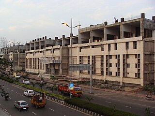
Avadi is a western suburb of Chennai, located within the Thiruvallur district of Tamil Nadu, India. Situated at about 22 kilometres (14 mi) from Chennai Central Railway Station, it is one of the four municipal corporations in the Chennai Metropolitan Area and is governed by the Avadi Municipal Corporation. It is surrounded by major defence establishments and is home to various universities and engineering colleges. The neighborhood is served by Avadi Railway Station of the Chennai Suburban Railway. As of 2011, Avadi had a population of 345,996, which is 10th most populous place in Tamil Nadu. It is home to the Heavy Vehicles Factory (HVF), Ordnance Factory Board (ODF) which houses Engine Factory and Combat Vehicles Research and Development Establishment (CVRDE). The lake in Avadi was known as Paaleripattu, which is now found only in very old land documents.

Chromepet is a neighbourhood of Tambaram located in the Chennai Metropolitan Area, around 22 km from the Chennai Central Railway Station and 4 km south of the Chennai International Airport on the Grand Southern Trunk. Formerly a part of Pallavaram Municipality,it is now governed by the Tambaram City Municipal Corporation.Neighbouring areas include Thirumudivakkam, Tambaram, and Pallavaram. The 200-feet road connects Chromepet with Thoraipakkam.
Thiruvanmiyur is a largely residential neighborhood in the south of Chennai, Tamil Nadu, India. Thiruvanmiyur witnessed a spike in its economy with the construction of Chennai's first dedicated technology office space, the Tidel Information Technology Park in neighboring Taramani. The subsequent rise of several information technology businesses, research centres and offices around Tidel park proved fortuitous for Thiruvanmiyur, as many of the workers at these offices often made Thiruvanmiyur their home. The Marundeeswarar Temple, dedicated to Shiva previously defined the area, leading it to be mentioned in Sangam Tamil epics. It is also commonly referred to as the MICO layout of Chennai city. Other Famous Temples are Ashtalakshmi Temple and Aarupadai Murugan Temple.
Ambattur is a northwestern neighbourhood of Chennai, India. It is located in Ambattur taluk of the Chennai District, surrounded by Avadi, Anna Nagar, Padi, Mogappair, Kallikuppam, Surapet, Korattur, Ayappakkam, Athipet and Thiruverkadu. It covers an area of 45 km2 (17 sq mi). The neighbourhood is served by Ambattur railway station of the Chennai Suburban Railway. Ambattur has its origins in a village of the same name which can be located at present as areas opposite to Ambattur telephone exchange. Ambattur was a village with large extents of agricultural farm lands irrigated by the once-sprawling Ambattur Lake. In 2011, the neighborhood had a population 466,205.

Ranipettai is a town in Tamil Nadu, India and the headquarters of Ranipet district. Ranipet is an industrial hub of greater Vellore city. It is located about 100 kilometres (62 mi) from the Chennai city center. It is a major industrial town located on NH 4 Chennai-Bangalore highway, on the northern bank of the Palar River.The estimated population is 397,000 as of 2024.
Egmore is a neighbourhood of Chennai, India. Situated on the northern banks of the Coovum River, Egmore is an important residential area as well as a commercial and transportation hub. The Egmore Railway Station was the main terminus of the Madras and Southern Mahratta Railway and later, the metre gauge section of the Southern division of the Indian Railways. It continues to be an important railway junction. The Government Museum, Chennai is also situated in Egmore. Other important institutions based in Egmore include the Government Women and Children's Hospital, the Tamil Nadu State Archives and the Tamil Nadu Archaeology Department. The Wesley Church, Egmore is the oldest church of the region.
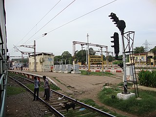
Basin Bridge Junction is a station on the Chennai Suburban Railway and serves the locality of Pulianthope & Moolakothalam, the confluence on the Otteri Nullah and Buckingham Canal, in Chennai, India. The station is located at the southern end of the 'diamond' junction in Chennai, where all the lines of the Chennai Suburban Railway meet. It is the first station after Chennai Central. At this station, the line divides into three: one going towards Avadi and Arakkonam, the other towards Ennore and Gummidipoondi, and the third towards Chennai Beach and Chennai Egmore. Thus, the station acts as the entry point to Chennai Central terminus where inbound trains from all the three lines are stopped before assigning a platform at Chennai Central. It also contains a railway maintenance shed with 19 pit-lines, each measuring 3-ft deep to accommodate about 24 coaches. The station has an elevation of 7 m above sea level.

Saidapet, also known as Saidai, is a neighbourhood in Chennai, India, situated in the northern banks of the Adyar River and serves as an entry point to Central Chennai. It is surrounded by West Mambalam in the North, C.I.T Nagar in the North-East, Nandanam in the East, Guindy in the South, Jafferkhanpet and Ashok Nagar in the North-West. The Saidapet Court, the only other court of judicature in Chennai city apart from the Madras High Court, and the Saidapet bus depot are located here. Prior to its incorporation in Madras city, Saidapet functioned as the administrative headquarters of Chingleput district. The neighbourhood is served by Saidapet railway station of the Chennai Suburban Railway Network.
Thirunindravur is a neighbourhood situated on the western part of Chennai district, Tamil Nadu, India. It is located around 29 km from Chennai Central railway station. Thirunindravur comes under Chennai Metropolitan Area. The neighbourhood is served by Thirunindravur railway station. It is famous for its temples. Thiruninravur lake serves the neighbourhood for its water needs. It serves as the connecting hub between Chennai and Tirupati.

Vaniyambadi is a town in the Tirupathur district of Tamil Nadu and the headquarter for the Vaniyambadi Revenue district comprising Vaniyambadi and Ambur. It is located about 200 km from Chennai and 178 kilometer from Bengaluru. The Vaniyambadi Municipality was formed by the G.O. MS. No. 421 Local & Municipality Dept. in April 1886. In 1996 this Municipality was upgraded to Grade II Municipality by G.O. MS. NO. 118 Rural Development Local Administration Dept. dated 01.05.1996. In 1998 this Municipality was upgraded to 1st Grade.
Pammal is a neighborhood in the city of Tambaram, situated within the Chennai Metropolitan Area, Tamil Nadu, India.

Tirusulam is a census town in Chengalpattu district falling within the Chennai metropolitan area,adjoining the Chennai International Airport, with the cargo terminal located at the adjacent Meenambakkam.
Mambalam is a residential and commercial area in Chennai, India. It is known for its shops, bazaars and Hindu temples. It is bounded by Kodambakkam to the north and Saidapet to the south. T. Nagar and Nandanam stretch all along its eastern frontiers while Ashok Nagar lies to its west. The Ayodhya Mandapam is an important landmark.
Aminjikarai, originally Amaindakarai, is one of the oldest neighbourhoods in Chennai, Tamil Nadu, India. The arterial Poonamallee High Road runs through it. Aminjikarai was annexed to Madras District in the year 1946, and Arumbakkam and Anna Nagar were carved out of Aminjikarai in the 1950s and 1970s. The Nelson Manickam Road that traverses through Aminjikarai is an important commercial road in Chennai city.
Tondiarpet is a northern neighbourhood of Chennai, Tamil Nadu, India.
Purasawalkam also known as Purasaiwakkam or Purasai / Purasawakkam, is a residential shopping area in the district of Chennai in the state of Tamil Nadu, India. It is close to the Chennai Central and Chennai Egmore railway stations.

George Town is a neighbourhood in Chennai, Tamil Nadu, India. It is near the Fort Saint George, Chennai. It is also known as Muthialpet and Parry's corner. It is an historical area of Chennai city from where its expansion began in the 1640s. It extends from the Bay of Bengal in the east to Park town on the west. The Fort St. George is on the south, to Royapuram in the north. The Fort St. George houses the Tamil Nadu Legislative Assembly and the Secretariat. The High court of Tamil Nadu at Chennai, Dr. Ambedkar Law College, Stanley Medical College and Hospital are located here.
Choolai is a developed residential area in Central Chennai, a metropolitan city in Tamil Nadu.
Pulianthope is a neighbourhood in Chennai district of Indian state of Tamil Nadu. It was initially known as "Medicine Warehouse" for Englishmen, so it was called "Marunthukedangu" and now it has changed to Pulianthope. From the days of Englishmen this place was very developed area in North Chennai. Also, it was surrounded with "Binny Mills" which was the biggest garment export factory, Basin bridge railway station, Chennai's biggest cattle slaughter house and meat supplier hub called "Aadudhotti".

Ranipet district is one of the 38 districts of Tamil Nadu, India, formed by trifurcating Vellore district. The Government of Tamil Nadu has announced its proposal on 15 August 2019, together with Tirupattur district. However, it was officially declared on 28 November 2019 by Tamil Nadu Government. The town of Ranipet would serve as the district headquarters.


