
Transport in Chennai includes various modes of air, sea, road and rail transportation in the city and its suburbs. Chennai's economic development has been closely tied to its port and transport infrastructure, and it is considered one of the best infrastructure systems in India.

Chennai Central, is an NSG–1 category Indian railway station in Chennai railway division of Southern Railway zone. It is the main railway terminus in the city of Chennai, Tamil Nadu, India. It is the busiest railway station in South India and one of the most important hubs in the country. It is connected to Moore Market Complex railway station, Chennai Central metro station, Chennai Park railway station, and Chennai Park Town railway station. It is about 1.8 km (1.1 mi) from the Chennai Egmore railway station. The terminus connects the city to major cities of India, including Bangalore, Kolkata, Mumbai, and New Delhi, and different parts of India.
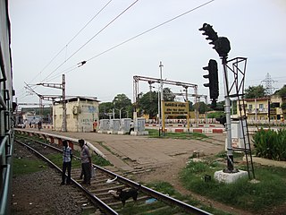
Basin Bridge Junction is a station on the Chennai Suburban Railway and serves the locality of Pulianthope & Moolakothalam, the confluence on the Otteri Nullah and Buckingham Canal, in Chennai, India. The station is located at the southern end of the 'diamond' junction in Chennai, where all the lines of the Chennai Suburban Railway meet. It is the first station after Chennai Central. At this station, the line divides into three: one going towards Avadi and Arakkonam, the other towards Ennore and Gummidipoondi, and the third towards Chennai Beach and Chennai Egmore. Thus, the station acts as the entry point to Chennai Central terminus where inbound trains from all the three lines are stopped before assigning a platform at Chennai Central. It also contains a railway maintenance shed with 19 pit-lines, each measuring 3-ft deep to accommodate about 24 coaches. The station has an elevation of 7 m above sea level.
Meenambakkam is a southern neighbourhood of Chennai in the Indian state of Tamil Nadu. It is home to Chennai International Airport, the Airports Authority of India regional office, and the DGQA Complex. It was under the reign of the Pallava kingdom. The name Meenambakkam signifies that it is a settlement near the coast. Pakkam means a settlement near to the coast. Meenambakkam was cherished with lakes, ponds and borderlines the Adyar river. This makes it a rich source of fishes. Hence the name Meenambakkam was coined.
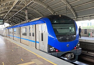
The Chennai Metro is a rapid transit system serving the city of Chennai, India. Operated by Chennai Metro Rail Limited (CMRL) – a joint venture between the Government of India and the State Government of Tamil Nadu, the network consists of two lines and spans 54.1 km (33.6 mi). The system uses standard gauge and has 41 underground and elevated stations.
Kochi is a major port city in the Indian state of Kerala. The city is widely known as the commercial or economic capital of the state of Kerala.
Vandalur is a census town and taluk headquarters in the Chengalpattu district lying south of the metropolitan city of Chennai, India. Vandalur serves as the southern gateway to Chennai city. It has the Arignar Anna Zoological Park, which contain some rare species of wild flora and fauna. The town is served by Vandalur railway station of the Chennai Suburban Railway network.
Vannarapettai (transl. Washermenpet) is a northern neighbourhood of Chennai, India. It is also known as Pazhaya Vannarapettai, sometimes shortened as Vannai. It is located north of Parrys Corner and adjacent to Royapuram. Washermanpet is famous for its jewelry shops and matchbox industries, many of which are centered on two main arterial roads.

The Chennai Suburban Railway is a commuter rail system in the city of Chennai, Tamil Nadu, India, operated by the Southern Railways branch of Indian Railways. It is the second largest suburban rail network in terms of route length and the third largest in terms of commuters in India. Around 1,000 services are operated daily between 4:00 a.m. and midnight. It is the longest suburban circular route in India covering of 235.5 km (146.3 mi).

Anna Salai, formerly known as St. Thomas Mount Road or simply Mount Road, is an arterial road in Chennai, India. It starts at the Cooum Creek, south of Fort St George, leading in a south-westerly direction towards St. Thomas Mount, and ends at the Kathipara Junction in Guindy. Beyond the Kathipara Junction, a branch road arises traversing westwards to Poonamallee to form the Mount-Poonamallee Road while the main branch continuing southwards to Chennai Airport, Tambaram and beyond to form Grand Southern Trunk Road. Anna Salai, which is more than 400 years old, is acknowledged as the most important road in Chennai city. The head offices of many commercial enterprises and public buildings are located along Anna Salai. It is the second longest road in Chennai, after EVR Periyar Salai.
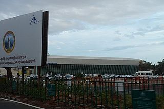
Coimbatore is a city in the state of Tamil Nadu, India. Most transportation in the city and suburbs is by road. Coimbatore is well-connected to most cities and towns in India by road, rail, and air, but not through waterways. The city has successful transport infrastructure compared to other Indian cities, though road infrastructures are not well maintained and developed according to the growing needs of transport, making traffic congestion a major problem in the city. A comprehensive transport development plan has been made to address many traffic problems.

The Coimbatore Bypass Road refers to a series of bypasses connecting the various National Highways and State Highways passing through and originating in the South Indian city of Coimbatore.

Washermanpet railway station is one of the railway stations in Chennai, India. It is one of the stations of the Chennai Beach–Gummidipoondi and Chennai Beach-Arakkonam sections of the Chennai Suburban Railway Network. It serves the neighbourhood of Washermanpet, Korukkupet and Tondiarpet. It is situated at Washermanpet, with an elevation of 9 m above sea level. The station lies at the eastern end of the 'diamond' junction of Chennai's railway network, where all the lines of the Chennai Suburban Railway meet.
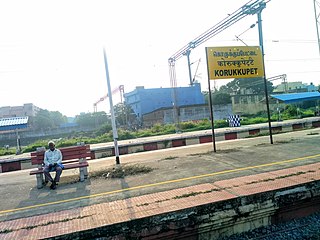
Korukkupet railway station is one of the railway station of the Chennai Central–Gummidipoondi section of the Chennai Suburban Railway Network. It serves the neighbourhood of Korukkupet, a suburb of Chennai, and is located 4 km north of Chennai Central railway station. It has an elevation of 7 m above sea level.
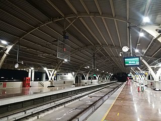
St. Thomas Mount railway station, locally known as Mount railway station or Parangimalai station, is one of the railway stations of the Chennai Beach–Chengalpattu section of the Chennai Suburban Railway Network. It serves the neighbourhood of St. Thomas Mount and Pazhavanthangal, which are suburbs of Chennai. It is located at a distance of 17 km (11 mi) from Chennai Beach terminus, with an elevation of 11 m (36 ft) above sea level.

Koyambedu Wholesale Market Complex (KWMC) is one of Asia's largest perishable goods market complex located at Koyambedu, Chennai. The market complex is spread over an area of 295 acres (1.19 km2). Inaugurated in 1996, the complex consists of about 3,100 shops, including more than 1,000 wholesale shops and 2,000 retail shops. Of these, 850 are fruit shops. It abuts the Poonamallee High Road and Nesapakkam Road and can be easily accessed from all parts of City. In Phase I, a wholesale market for perishables was developed in an area of around 70 acres (280,000 m2) by constructing 3,194 shops. The market has two blocks for vegetable shops and one each for fruit and flower shops. In Phase II, a textile market and in Phase III, a food grain market have been planned to be developed in the complex.

The Blue Line is one of the two operational lines of Chennai Metro apart from the Green line. The line stretches from Chennai Airport to Wimco Nagar Depot, covering a distance of 32.65 km (20.29 mi). The line consists of 26 stations out of which 13 stations are underground and the rest are elevated or on ground level. In May 2018, operations on the blue line commenced between Saidapet and AG-DMS with the extended underground stretch from AG-DMS to Washermanpet of blue line commencing operations on 10 February 2019 completing the phase 1 of the metro.

The Green Line is one of the two operational lines of Chennai Metro apart from the Blue line. The line stretches from Chennai Central to St. Thomas Mount, covering a distance of 22 km (14 mi). The line consists of 17 stations out of which nine stations are underground and the rest are elevated or on ground level.
Coimbatore Metro, also known as Kovai Metro, is a proposed rapid transit system for Coimbatore, Tamil Nadu.
Basin bridge is a neighbourhood in Chennai district of Tamil Nadu state in the peninsular India. It is located at an altitude of about 28 m above the mean sea level with the geographical coordinates of 13°06′23.5″N80°16′31.2″E. George Town, Royapuram, Kondithope, Mannadi Vannarapettai, Tondiarpet, Sowcarpet, Vallalar Nagar and Kasimedu are some of the important neighbourhoods of Basin Bridge area.


