
The Chennai Mass Rapid Transit System, a state-owned subsidiary of Indian Railways, is a metropolitan elevated railway line in Chennai, India. Operated by the Southern Railways, it is the first elevated railway line in India and also the country's longest elevated corridor spanning 17 km. Although it is segregated from the Chennai Suburban Railway, they both are operated by Southern Railway and are integrated in a wider urban rail network. Built at a cost of ₹ 15,710 million, the line runs within the city limits from Chennai Beach to Velachery, covering a distance of 19.34 km (12.02 mi) with 18 stations, with an average daily ridership of 100,000 commuters. Connecting the central business area of old Madras with the IT corridor, the section has a potential capacity of 425,000 passengers a day. In 2011–2012, MRTS registered a revenue of ₹ 198.9 million, registering a 16.25 percent increase, with 134 trains plying across all the 17 stations.

Adambakkam is a neighbourhood of Chennai, India. It is primarily a residential locality situated in South Chennai. Adambakkam area comes under Velachery taluk and Alandur taluk, Chennai District of Chennai Corporation. Adambakkam is surrounded by areas namely, Alandur in the North-West, Nanganallur in the West, Madipakkam in the South, Velachery in the East and Guindy in the North. Earlier, one part of Adambakkam was under the direct governance of Chennai Corporation. From October 2011 onwards, the entire area was merged with the Chennai Corporation. Upon completion of the MRTS extension line, the neighbourhood will be served by Adambakkam railway station. Its Proximity to commercial localities like Velachery, accessible railway stations, Metro Stations and road transport routes makes Adambakkam an ideal choice of location to live.

Avadi is a suburb of Chennai, located in the Thiruvallur district of Tamil Nadu, India. It is a municipal corporation lying to the west of Chennai, about 22 kilometres (14 mi) west of Chennai Central Railway Station. It is surrounded by major defence establishments and is home to various universities and engineering colleges. The city is served by Avadi Railway Station of the Chennai Suburban Railway. As of 2011, Avadi had a population of 345,996. It is home to the Heavy Vehicles Factory (HVF), Ordnance Factory Board (ODF) which houses Engine Factory and Combat Vehicles Research and Development Establishment (CVRDE). The lake in Avadi was known as Paaleripattu, which is now found only in very old land documents. Avadi is also a part of the Chennai Metropolitan Area.

Transport in Chennai includes various modes of air, sea, road and rail transportation in the city and its suburbs. Chennai's economic development has been closely tied to its port and transport infrastructure, and it is considered one of the best infrastructure systems in India.
Chennai Egmore is a railway station in Chennai, Tamil Nadu, India. Situated in the neighborhood of Egmore, it is one of the four intercity railway terminals in the city; the other three are Chennai Central railway station, Tambaram railway station and Chennai Beach railway station. The station was built in 1906–1908 as the terminus of the South Indian Railway Company. The building built in Gothic style is one of the prominent landmarks of Chennai. The main entrance to the station is situated on Gandhi-Irwin Road and the rear entrance on Poonamallee High Road.

Puratchi Thalaivar Dr. M.G. Ramachandran Central Railway Station, commonly known as Chennai Central, is the main railway terminus in the city of Chennai, Tamil Nadu, India. It is the busiest railway station in South India and one of the most important hubs in the country. It is connected to Moore Market Complex railway station, Chennai Central metro station, Chennai Park railway station, Chennai Park Town railway station and is 2 km from Chennai Egmore railway station. The terminus connects the city to northern India, including Kolkata, Mumbai, New Delhi and Ahmedabad as well as to Bangalore, Coimbatore, Hyderabad and different parts of Kerala.
Egmore is a neighbourhood of Chennai, India. Situated on the northern banks of the Coovum River, Egmore is an important residential area as well as a commercial and transportation hub. The Egmore Railway Station was the main terminus of the Madras and Southern Mahratta Railway and later, the metre gauge section of the Southern division of the Indian Railways. It continues to be an important railway junction. The Government Museum, Chennai is also situated in Egmore. Other important institutions based in Egmore include the Government Women and Children's Hospital, the Tamil Nadu State Archives and the Tamil Nadu Archaeology Department. The Wesley Church, Egmore is the oldest church of the region.

Chepauk is a locality in Chennai, India. The name Chepauk is popularly used to refer to the M. A. Chidambaram International Cricket Stadium, also known as the Chepauk Stadium. It is also home to the Chepauk Palace, built in the Indo-Saracenic style. The University of Madras campus is yet another prominent landmark of Chepauk. The Central Research laboratory is located here. It is believed that the name "Chepauk" itself might have been derived from the Hindi word "Che Bagh" meaning "Six gardens". Chepauk's postal index number (PIN) code is 600005. The main roads of Chepauk are Bells Road and Walajah Road.
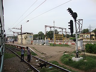
Basin Bridge Junction is a station on the Chennai Suburban Railway and serves the locality of Basin Bridge, the confluence on the Otteri Nullah and Buckingham Canal, in Chennai, India. The station is located at the southern end of the 'diamond' junction in Chennai, where all the lines of the Chennai Suburban Railway meet. It is the first station after Chennai Central. At this station, the line divides into three: one going towards Avadi and Arakkonam, the other towards Ennore and Gummidipoondi, and the third towards Chennai Beach and Chennai Egmore. Thus, the station acts as the entry point to Chennai Central terminus where inbound trains from all the three lines are stopped before assigning a platform at Chennai Central. It also contains a railway maintenance shed with 19 pit-lines, each measuring 3-ft deep to accommodate about 24 coaches. The station has an elevation of 7 m above sea level.

Poonamallee is a neighbourhood in the west of Chennai, India. It is a town in the Poonamallee taluk of the Tiruvallur district in the Indian state of Tamil Nadu. The nearest Railway station is at Thiruninravur. It acts as the gateway to the city from its western side. It is a town with rich cultural heritage and also a fast-growing areas in the city. As of 2011, the town had a population of 57,224. There are plans to merge the areas under Poonamallee Municipality with Avadi Municipal Corporation.
Chennai Beach is a railway terminus of the Southern Railway network in Parry's Corner, Chennai, India. Built on reclaimed land, the station serves the suburban services of the Chennai Suburban Railway and Mass Rapid Transit System (Chennai) and a few passenger trains. It serves as the northern terminus for the Chennai MRTS line. The station is named after High Court Beach, which was later built up as part of Chennai Port, and not after the Marina Beach, which is located a few kilometres away and is served by Chepauk, Triplicane and Lighthouse stations of the MRTS line. The station consists of 1500 square metres of open parking area.

The Chennai Suburban Railway is a commuter rail system in the city of Chennai, Tamil Nadu, India, operated by the Indian Railways. It is the second largest suburban rail network in terms of route length and the third largest in terms of commuters in India. Around 1,000 services are operated daily between 4:00 a.m. and midnight. It is the longest suburban circular route in India covering of 235.5 km (146.3 mi).

Anna Salai, formerly known as St. Thomas Mount Road or simply Mount Road, is an arterial road in Chennai, India. It starts at the Cooum Creek, south of Fort St George, leading in a south-westerly direction towards St. Thomas Mount, and ends at the Kathipara Junction in Guindy. Beyond the Kathipara Junction, a branch road arises traversing westwards to Poonamallee to form the Mount-Poonamallee Road while the main branch continuing southwards to Chennai Airport, Tambaram and beyond to form Grand Southern Trunk Road. Anna Salai, which is more than 400 years old, is acknowledged as the most important road in Chennai city. The head offices of many commercial enterprises and public buildings are located along Anna Salai. It is the second longest road in Chennai, after EVR Periyar Salai.

George Town is a neighbourhood in Chennai, Tamil Nadu, India. It is near the Fort Saint George, Chennai. It is also known as Muthialpet and Parry's corner. It is an historical area of Chennai city from where its expansion began in the 1640s. It extends from the Bay of Bengal in the east to Park town on the west. The Fort St. George is on the south, to Royapuram in the north. The Fort St. George houses the Tamil Nadu Legislative Assembly and the Secretariat. The High court of Tamil Nadu at Chennai, Dr. Ambedkar Law College, Stanley Medical College and Hospital are located here.
Chennai Monorail was a proposal for a number of lines as part of mass transit system for the Indian city of Chennai. Originally the city planned to use monorail on all lines but many were subsequently changed to railways as part of the Chennai Metro.

Chennai Park Town is a station on the Chennai MRTS. Located just to the east of Pallavan Salai and to the south of the Rajiv Gandhi Government General Hospital in the Park Town neighbourhood of Chennai, it exclusively serves the Chennai MRTS. The station is adjacent to Chennai Park, which serves the Chennai Suburban Railway. It is also within walking distance to Chennai Central. Although within walking distance, a 1 km overhead pedestrian walkway is being planned to connect Chennai Central with the MRTS station. Beware of thieves in this station as many mobile theft/snatching incidents has been taken place in Park Town station.

Chennai Park railway station is one of the railway stations in Chennai, India, on the Chennai Beach–Chengelpet section of the Chennai Suburban Railway Network. It serves the neighbourhood of Park Town, a suburb of Chennai. It is located at about 3 km from Chennai Beach terminus and is situated on Poonamallee High Road, across Chennai Central railway station. It has an elevation of 7 m above sea level.
EVR Periyar Salai (EVR High Road), earlier known as Poonamallee High Road(NH 48) and originally the Grand Western Trunk Road, is an arterial road in Chennai, India. It is the longest road in Chennai. Running from east to west, the 14-kilometre (8.7 mi) road starts at Muthuswamy Bridge near Madras Medical College at Park Town and ends near Maduravoyal Junction via Kilpauk, Aminjikarai, Anna Nagar Arch, Arumbakkam, Koyambedu. It further continues west towards Poonamallee and traverses Sriperumbudur, Walajapet, and Ranipet.
The Central Square is an upcoming city square and major intersection being developed by the Government of Tamil Nadu in Park Town, Chennai. Areas surrounding the Ripon Building, Victoria Public Hall, Moore Market Complex, Chennai Central Railway Station, the Southern Railway Headquarters and the Government General Hospital are being developed as part of the Central Square. The total site area is estimated to be about 37,800 square meter, and the development is estimated to cost about ₹4 billion (US$52 million) and will be funded by the CMDA.

Puratchi Thalaivar Dr. M.G. Ramachandran Central Metro, commonly known as the Chennai Central Metro, is an underground metro station in Chennai, India. It serves both lines of the Chennai Metro. Central metro station is spread over an area of 30,000 square metres (320,000 sq ft). On 31 July 2020, It has been named by Government of Tamil Nadu as Puratchi Thalaivar Dr. M.G. Ramachandran Central Metro to honor the All India Anna Dravida Munnetra Kazhagam founder and the former Chief Minister of Tamil Nadu M. G. Ramachandran.


