Thiruvanmiyur

Last updated

Thiruvanmiyur
neighbourhood
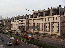
Thiruvanmiyur Station.JPG
Thiruvanmiyur MRTS station
Chennai area locator map.svg
Red pog.svg
Thiruvanmiyur
India Tamil Nadu location map.svg
Red pog.svg
Thiruvanmiyur
India location map.svg
Red pog.svg
Thiruvanmiyur
Coordinates: 12°59′08″N80°15′41″E / 12.9856°N 80.2614°E / 12.9856; 80.2614
CountryIndia
State Tamil Nadu
District Chennai
TalukVelachery
MetroChennai
ZoneAdyar
Ward155
Languages
  Official Tamil
Time zone UTC+5:30 (IST)
PIN
600041
Vehicle registration TN-07
Lok Sabha constituencyChennai South
Vidhan Sabha constituencyVelachery
Website https://tourismtn.com/thiruvanmiyur-beach/
Thiruvanmiyur beach Thiruvanmiyur BEACH AREA .jpg
Thiruvanmiyur beach

Thiruvanmiyur is a largely residential neighborhood in the south of Chennai, Tamil Nadu, India. Thiruvanmiyur witnessed a spike in its economy with the construction of Chennai's first dedicated technology office space, the Tidel Information Technology Park in neighboring Taramani. The subsequent rise of several information technology businesses, research centres and offices around Tidel park proved fortuitous for Thiruvanmiyur, as many of the workers at these offices often made Thiruvanmiyur their home. The Marundeeswarar Temple, dedicated to Shiva previously defined the area, leading it to be mentioned in Sangam Tamil epics. It is also commonly referred to as the MICO layout of Chennai city. Other Famous Temples are Ashtalakshmi Temple and Aarupadai Murugan Temple.

Contents

Etymology

Road and Transport

Buses

The area is easily accessible by Metropolitan Transport Corporation (MTC) buses and has a sprawling bus terminus. The MTC bus stops in the area are Jeyanthi Theatre, Thiruvanmiyur Bus Stand, Marundeeswarar temple, R.T.O office and Tidel park. SETC buses heading towards Pondicherry passes through the area and has a bus stop.

Railways

Thiruvanmiyur Railway station, opposite to Tidel Park, is on the Mass Rapid Transit System Railway line which connects Velachery and Beach via Chennai Central(Park Station). STPI, also known as Software Technology Parks of India, located near Tidel Park, is another hub for Information Technology companies.

Road

The East Coast Road starting in Thiruvanmiyur leads to Mahabalipuram and Pondicherry.

Facilities and attractions

Sunrise at the Thiruvanmiyur beach Sunrise at Thiruvanmiyur Beach.jpg
Sunrise at the Thiruvanmiyur beach

The main post office is located east of Lattice Bridge (LB) Road, around 100 meters before it meets Old Mahabalipuram Road. The two main theatres in the area are the Jayanthi (currently demolished to make way for a housing project) and the Theyagaraja / Sathyam S2. The South Chennai RTO is also located here on ECR. Kamarajar Hall is the biggest Auditorium present here.

Thiruvanmiyur Beach or RTO Beach is a popular attraction and the beach line is 1 km from East Coast Road. The Beach Walkers promenade is very popular with the local residents. The beach is a maintained clean with active support from the local community. The local community with the support of cotton house, has made an elderly walker's resting spot named after Dr.A.P.J.Abdul Kalam (the former president of India).

Schools: CBSE-Shraddha Children's Academy, Kottivakkam, State Board-Nellai Nadar Matriculation School, Sri Sankara Vidyashram matriculation higher secondary school, K.S.N Senior Secondary School

Places of worship

Temples

Sage Valmiki Valmiki Ramayana.jpg
Sage Valmiki

Location in context

Related Research Articles

<span class="mw-page-title-main">Tharamani</span> Neighbourhood in Chennai, Tamil Nadu, India

Tharamani is an area in the south Indian city of Chennai. It is known for the presence of the city's first IT parks and numerous government educational and research institutions. It is located adjacent to the posh residential area of Adyar and Besant Nagar in South Chennai. It is an Estate with Express IT Companies, making it a massive located neighbourhood in the IT Expressway.

<span class="mw-page-title-main">Adambakkam</span> Neighborhood of Chennai, India

Adambakkam is a neighbourhood of Chennai, India. It is primarily a residential locality situated in South Chennai. Adambakkam area comes under Velachery taluk and Alandur taluk, Chennai District of Chennai Corporation. Adambakkam is surrounded by areas namely, Alandur in the North-West, Nanganallur in the West, Madipakkam in the South, Velachery in the East and Guindy in the North. Earlier, one part of Adambakkam was under the direct governance of Chennai Corporation. From October 2011 onwards, the entire area was merged with the Chennai Corporation. Upon completion of the MRTS extension line, the neighbourhood will be served by Adambakkam railway station. Its Proximity to commercial localities like Velachery, accessible railway stations, Metro Stations and road transport routes makes Adambakkam an ideal choice of location to live.

<span class="mw-page-title-main">Avadi</span> Suburb of Chennai, India

Avadi is a western suburb of Chennai, and the headquarters of Avadi taluk located within the Thiruvallur district of Tamil Nadu, India. Situated at about 22 kilometres (14 mi) from Chennai Central Railway Station, it is one of the four municipal corporations in the Chennai Metropolitan Area and is governed by the Avadi Municipal Corporation. It is surrounded by major defence establishments and is home to various universities and engineering colleges. The neighborhood is served by Avadi Railway Station of the Chennai Suburban Railway and just 7 km from the upcoming Karayanchavadi Metro of Chennai Metro Rail. As of 2011, Avadi had a population of 345,996, which is 10th most populous place in Tamil Nadu. It is home to the Heavy Vehicles Factory (HVF), Ordnance Factory Board (ODF) which houses Engine Factory and Combat Vehicles Research and Development Establishment (CVRDE). The lake in Avadi was known as Paaleripattu, which is now found only in very old land documents.

<span class="mw-page-title-main">TIDEL Park</span> Tech Park in Chennai, India

TIDEL Park is an information technology (IT) park situated in the city of Chennai, India. The name TIDEL is a portmanteau of TIDCO and ELCOT. An ISO 9001/14001 company, In 2000, it was one of the largest IT parks in India. It was set up in 2000 to foster the growth of information technology in the state of Tamil Nadu by the TIDEL Park Ltd, a joint venture of TIDCO and ELCOT.

Ambattur is a northwestern part of Chennai, India. It is located in Ambattur taluk of the Chennai District, surrounded by Avadi, Anna Nagar, Korattur, Padi, Mogappair, Kallikuppam, Surapet, Ayappakkam, Athipet and Thiruverkadu. It covers an area of 40.36 km2 (15.58 sq mi). The neighbourhood is served by Ambattur railway station of the Chennai Suburban Railway. Ambattur has its origins in a village of the same name which can be located at present as areas opposite to Ambattur telephone exchange. Ambattur was a village with large extents of agricultural farm lands irrigated by the once-sprawling Ambattur Lake. In 2011, the neighborhood had a population 466,205.

<span class="mw-page-title-main">Kelambakkam</span> Place in Tamil Nadu, India

Kelambakkam is a suburban and residential neighbourhood of Chennai, India. It is located in the south-eastern portion of the city along the Old Mahabalipuram Road (OMR), and is about 5 km from Siruseri IT park and 12 km from Sholinganallur junction. It is another important junction after Sholinganalur, which connects GST road (Vandalur) and ECR road (Kovalam). Kelambakkam is considered as the Southern Gateway to Chennai city on OMR Road and comes under Zone-2 of OMR Road.

Nanganallur or Nangainallur is one of the southern neighborhoods of Chennai, India. Since September 2011, it has become a part of Chennai Corporation. It is a residential area close to the Chennai International Airport.

<span class="mw-page-title-main">Poonamallee</span> Suburb of Chennai, India

Poonamallee is a town and suburb of Chennai, India under the Chennai Metropolitan Area. It was historically called Pushpagirimangalam, later renamed in Tamil as Poovirundhavalli, and now colloquially called as Poondhamalli. It is the headquarters of the Poonamallee taluk of the Tiruvallur district in the Indian state of Tamil Nadu. The nearest Railway station is at Avadi. It acts as the gateway to the city from its western side. It is a town with rich cultural heritage and also a fast-growing areas in the city. As of 2011, the town had a population of 57,224. There are plans to merge the areas under Poonamallee Municipality with Avadi Municipal Corporation.

<span class="mw-page-title-main">Tiruttani</span> Town in Tamil Nadu, India

Tiruttani is a historic temple town situated in the Tiruvallur district and serves as a suburb of Chennai within the Chennai Metropolitan Area in the southern Indian state of Tamil Nadu. The town is famous for the Tiruttani Murugan Temple, an ancient Hindu temple dedicated to Kartikeya, also known as Murugan, the Hindu god of war. This temple is one of the Arupadaiveedu, a group of six significant abodes of Murugan. Tiruttani was officially incorporated into the Chennai Metropolitan Area in October 2022, signifying its growing importance and influence within the region..

<span class="mw-page-title-main">East Coast Road</span> Road in Tamil Nadu, India

East Coast Road (ECR), combination of SH-49, NH-332A, NH-32, officially known as Mutthamizh Arignar Kalaignar Road, is a two-lane highway in Tamil Nadu, India, built along the Bay of Bengal coast. It connects Tamil Nadu's state capital Chennai with Kanyakumari via Puducherry, Cuddalore, Chidambaram, Sirkali, Thirukkadaiyur, Tharangambadi, Karaikal, Nagore, Nagapattinam, Thiruthuraipoondi, Muthupet, Adirampattinam, Manora,Peravurani,Manamelkudi, Mimisal, Ramanathapuram, Rameswaram,Thoothukudi, Tiruchendur, Uvari, Kudankulam. The total length of the road is about 777 km between Chennai and Kanyakumari.

<span class="mw-page-title-main">Peelamedu</span> Coimbatore, Tamil Nadu, India

Peelamedu is a major commercial centre and residential locality in the Eastern part of the city of Coimbatore in Tamil Nadu, India. It is governed by Coimbatore City Municipal Corporation since 1981. The growth of Peelamedu during the last decade can be cited due to the growth of the IT sector in Coimbatore. The rapid growth of Peelamedu as a commercial and residential hub could be attributed to its geographical advantage in terms of the connectivity to other parts of the city. It acts as an important hub connecting the rapidly growing business class Information Technology corridor. The Peelamedu area stretches from Nava India to the Coimbatore International Airport near SITRA, encompassing major educational institutions, hospitals, and Industries.

Siruseri is a southern suburb of Chennai, India. It is a village under Thiruporur panchayat union in Chengalpattu district, Tamil Nadu, and is 35 km from Chennai, along the Old Mahabalipuram Road. It is located between Navalur and Kelambakkam.

Karapakkam is an area of Chennai, in Tamil Nadu, India. It is one of the stops on the Old Mahabalipuram Road, or commonly referred to as OMR. It is situated between the IT Hubs of Thoraipakkam and Sholinganallur. It is parallel to Injambakkam on the ECR Highway.

<span class="mw-page-title-main">Marundeeswarar Temple</span> Hindu temple in Chennai, Tamil Nadu, India

Marundeeswarar Temple is a temple dedicated to Hindu deity Shiva, located in Thiruvanmiyur, Chennai adjacent to the beach of Bay of Bengal. It is one of the 275 Paadal Petra Sthalams where two of the most revered Nayanars, Appar and Tirugnana Sambandar, have glorified the temple with their verses during the 7th century CE. The temple has been widely expanded by Chola kings during the 11th century CE. The temple has two seven-tiered gateway towers, a huge tank, with the overall temple area covering 1 acre. The Marundeeswarar temple has been a place of curative worship for people with diseases.

Madhavaram Milk Colony is a neighbourhood in northern Chennai, a metropolitan city in Chennai district in the Indian state of Tamil Nadu.

Muthapudupet is a sublocality of Pattabiram in Avadi which is a neighbourhood in Chennai comes under the Avadi Municipal Corporation limit and Chennai Metropolitan area. Muthapudupet is around 700 metres from Pattabiram E Depot Railway Station, 2.5km from TIDEL Park and 7 km from Avadi Junction and 29 km from Chennai Central. The Chennai Outer Ring Road (ORR) and CTH Road passes near Muthapudupet

<span class="mw-page-title-main">ICF Colony</span> Neighbourhood in Chennai, Tamil Nadu, India

ICF Colony is a locality in Ayanavaram neighbourhood in Chennai, Tamil Nadu, India, where the Integral Coach Factory, (ICF) is located. The area also consists of a bus depot and the ICF Hospital. The locality has an MTC bus depot connecting the locality to areas such as Thiruvanmiyur.

Appanur is a village in the Kadaladi Taluk of Ramanathapuram District in Tamil Nadu, India. It is located between Mudukulathur and Sayalgudi, on the State Highway 29 (SH29).

<span class="mw-page-title-main">Hindu Religious and Charitable Endowments Department</span> Tamil Nadu government to maintain Hindu temples

The Hindu Religious and Charitable Endowments Department of the Government of Tamil Nadu manages and controls the temple administration within the state. The Tamil Nadu Hindu Religious and Charitable Endowments Act XXII of 1959 controls 36,425 temples, 56 mathas or religious orders, 1,721 specific endowments and 189 trusts.

Perungavoor, is a suburb located North of Chennai, a metropolitan city in Tamil Nadu, India.

References

  1. Padmanabhan, Geeta (16 July 2013). "Back in Time". The Hindu.
  2. Manivannan, Sharanya (26 March 2017). "On a midnight walk: What Chennai means to the turtles". Hindustan Times.
  3. "Arulmigu Marundeeswarar Temple Thiruvanmiyur, Chennai". Archived from the original on 10 April 2015.