Tiruvallur district, also spelled as Thiruvallur district, is one of the 38 districts in the Indian state of Tamil Nadu. The fast developing city of Tiruvallur is the district headquarters. The district has a mixture of urban and rural characteristics. The eastern part of Tiruvallur district is dominated by urban characteristics while the Northern part of the district has influence of Andhra culture due to its position. In 2011, the district had a population of 3,728,104 with a sex-ratio of 987 females for every 1,000 males.

Tiruvallur is a Grade I municipality in the Indian state of Tamil Nadu. It is located on the banks of Coovum river about 46 km (29 mi) from downtown Chennai (Madras) and just 5 km from megacity border, in the western part of the Chennai Metropolitan Area (CMA). It is a satellite town of Chennai and is the administrative headquarters of Tiruvallur district. The town is known for the Veeraraghava Swamy Temple, one of the 108 sacred shrines of Vaishnavites. The tank festival is held at a pond near this temple. A Shiva temple near this shrine which is popular among the locals. There is also a 40-foot (12 m) tall Viswaroopa Panchamukha Hanuman temple, where the murti is made of a single green granite stone.

Chennai district, formerly known as Madras district, is one of the 38 districts in the state of Tamil Nadu, India. It is the smallest and the most densely populated district in the state. The district is coterminous with the city of Chennai, which is administered by the Greater Chennai Corporation. It is surrounded by Tiruvallur district in the north and the west, Kanchipuram district in the south-west, Chenglpattu district in the south, and the Bay of Bengal in the east.

Tiruttani is a town in the Tiruvallur district, a suburb of Chennai within the Chennai Metropolitan Area, located in the state of Tamil Nadu, India. The town is renowned for the Tiruttani Murugan Temple, which is one of the Arupadaiveedu and is dedicated to Kartikeya (Murugan). Tiruttani was added to the Chennai Metropolitan Area in October 2022.
Pallipattu is a town in Tamil Nadu and a border town located between the Chittoor District of Andhra Pradesh and Tiruvallur District of Tamil Nadu. It is known for its fertile agricultural lands and the west-to-east flowing river Kusasthalai.
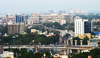
Greater Chennai Metropolitan Area, or simply the Chennai Metropolitan Area (CMA), is fifth-most populous metropolitan area in India and the 35th most populous in the world. The CMA consists of the core city of Chennai, which is coterminous with the Chennai district, and its suburbs in Kanchipuram, Chengalpattu, Thiruvallur and Ranipet districts. The Chennai Metropolitan Development Authority (CMDA) is the nodal agency that handles town planning and development within the metro area. In 1974, an area encompassing 1,189 km2 (459 sq mi) around the city was designated as the metropolitan area which was subsequently expanded to 5,904 km2 (2,280 sq mi) in 2022.
Erikuthi is a village in Gudiyatham Taluk, Vellore District, Tamil Nadu, India. It lies near the state boundary with Andhra Pradesh, about 16 kilometres west of the subdistrict capital Gudiyatham, and 45 kilometres west of the district capital Vellore. As of 2011, it had a population of 8,057.
Periapalayam is a village about 40 km north of Chennai, in Tiruvallur district, Tamil Nadu State, India. The nearest Railway station is Thiruninravur.It is in Ellapuram block which stretches from east Thanakulam village, west Uthukottai, north Kosavanpettai and in the south up to Komakambedu village. It has one of the main routes to Andhra Pradesh.
Arambakkam is a village in the Tiruvallur district of Tamil Nadu, India. It is located in the Gummidipoondi taluk.
Ambattur taluk is a taluk of Chennai district of the Indian state of Tamil Nadu. Its headquarters are the neighbourhood of Ambattur. This taluk was created from a division of Ponneri taluk, Tiruvallur district. On 4 January 2018, Chennai district was expanded by annexing Ambattur taluk. The RTO code for Ambattur taluk is TN-13.
- Ambattur
- Athipet
- Karukku
- Kallikuppam
- Pudur
- Korattur
- Menambedu
- Anna Nagar West extension
- Mogappair
- Oragadam
- Padi
- Pattravakkam.
Uthukkottai taluk is a taluk of Tiruvallur district of the Indian state of Tamil Nadu. The headquarters of the taluk is the town of Uthukkottai.
Poondi is a village in the Thiruvallur taluk of Tiruvallur district, Tamil Nadu, India. It has a fresh water lake to cater the daily needs of water for Chennai City. The place is also known for Oondreswarar Temple, which was displaced to its current location to ease the construction of the reservoir.
Egattur is a neighbourhood in Chennai, India. It is a village in Tiruvallur district of Tamil Nadu, located on the western outskirts of Chennai. In the 2011 census it had a population of 4842 in 1251 households.
Madhavaram taluk is a taluk of Chennai district in the Indian state of Tamil Nadu. The centre of the taluk is the neighbourhood of Madhavaram. The headquarters of the taluk is Tondiarpet division. And the taluk has been bifurcated from Ambattur taluk and on 2018 it has been annexed to Chennai district from tiruvallur by expanding Chennai city. And the taluk Has regions of Kathirvedu, Lakshmipuram, Madhavaram, Madhavaram Milk Colony, Mathur, Ponniammanmedu, Puthagaram, Puzhal, Surapet, Redhills, and the RTO of the taluk is TN 05.
Sunnambukkulam is a village in the Tiruvallur district of Tamil Nadu, India. It is located in the Gummidipoondi taluk.
Madharpakkam is a village in the Tiruvallur district of Tamil Nadu, India. Part of it is located in the Gummidipoondi taluk. This village is located near Andhra Pradesh border. The villagers main source of employment depends on Gummidipoondi sipcot. This village consists of four panchayats namely Madharpakkam, Padirivedu, Manellore and Nemallur. The Government higher secondary school is one of the oldest school in the district. Telugu and Tamil are major languages spoken by people.
Pondavakkam is a village in the Tiruvallur district of Tamil Nadu, India. It is located in the Gummidipoondi taluk.
Kannankottai is a village in the Tiruvallur district of Tamil Nadu, India. It is located in the Gummidipoondi taluk.
Budur is a village in the Tiruvallur district of Tamil Nadu, India. It is located in the Gummidipoondi taluk.
Morai is a village in Ambattur Taluk, Tiruvallur District, Tamil Nadu, India. It is located in the western suburb of Chennai, about 23 kilometres away from the city center. As of 2011, it had a total population of 10,873.

