Kanchipuram district is one of the 38 districts in the state of Tamil Nadu in India. The area comprising the present day Kancheepuram district was earlier a part of Chingleput district. The original Chingleput district was split in 1997 into form the present day Kanchiepuram and Tiruvallur districts.

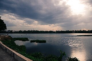
Tiruvallur is a Grade I municipality in the Indian state of Tamil Nadu. It is located on the banks of Coovum river about 46 km (29 mi) from downtown Chennai (Madras) and just 5 km from megacity border, in the western part of the Chennai Metropolitan Area (CMA). It is a satellite town of Chennai and is the administrative headquarters of Tiruvallur District. The town is known for the Veeraraghava Swamy Temple, one of the 108 sacred shrines of Vaishnavites. The tank festival is held at a pond near this temple. A Shiva temple near this shrine which is popular among the locals. There is also a 40-foot (12 m) tall Viswaroopa Panchamukha Hanuman temple, where the murti is made of a single green granite stone.

Porur is a neighbourhood of Chennai, India. It is situated in the Maduravoyal taluk of Chennai district in the southern part of the city. Since 2011, it has been a part of the Chennai Corporation and included in zone number 11.
Veppampattu is one of the fastest developing suburban areas in Chennai City. It is Western part of the suburbs of the Metropolitan city Chennai in the Indian state of Tamil Nadu between Chennai and Arakkonam on the Chennai - Arakkonam railway line. It is fast-growing with a number of schools and colleges. Electric trains and NH 205 road provide transportation to Chennai. Veppampatu can be approached by both train and bus. Bus stop is a very nearby railway station. Veppampattu comes under Chennai Metropolitan Area.
Alandur is a zone of Chennai corporation, and an urban node in Chennai district in Guindy division in the state of Tamil Nadu, India. It is surrounded by Guindy in the north and east, Adambakkam in the south, Pazhavanthangal in the south-west and Parangimalai in the north-west. As of 2011, Alandur had a population of 164,430. The town agglomeration of Alandur will have an estimated population of 300,000 by 2030. Alandur neighbours the St. Thomas Mount Cantontment, the Officers Training Academy of the Indian army and the nearby towns of Guindy and Adambakkam. M. G. Ramachandran, a former chief minister of Tamil Nadu started his political career by winning his first legislative election from Alandur in 1967. Alandur also holds famous landmarks of Chennai namely Nehru Statue and Kathipara Junction.

Poonamallee is a town and suburb of Chennai, India under the Chennai Metropolitan Area. It was historically called Pushpagirimangalam, later renamed in Tamil as Poovirundhavalli, and now colloquially called as Poondhamalli. It is the headquarters of the Poonamallee taluk of the Tiruvallur district in the Indian state of Tamil Nadu. The nearest Railway station is at Avadi. It acts as the gateway to the city from its western side. It is a town with rich cultural heritage and also a fast-growing areas in the city. As of 2011, the town had a population of 57,224. There are plans to merge the areas under Poonamallee Municipality with Avadi Municipal Corporation.

Tiruttani is a historic temple town situated in the Tiruvallur district and serves as a suburb of Chennai within the Chennai Metropolitan Area in the southern Indian state of Tamil Nadu. The town is famous for the Tiruttani Murugan Temple, an ancient Hindu temple dedicated to Kartikeya, also known as Murugan, the Hindu god of war. This temple is one of the Arupadaiveedu, a group of six significant abodes of Murugan. Tiruttani was officially incorporated into the Chennai Metropolitan Area in October 2022, signifying its growing importance and influence within the region..
Mangadu is a neighborhood to the west of Chennai, India. Literally meaning a mango forest. The Mangadu Municipality is about 18 km from Chennai Central railway station, 14 km from Chennai International Airport and 13 km from CMBT.
Pammal is a southern suburb in Chennai, Tamil Nadu, India.
Anakaputhur is a neighborhood in the city of Tambaram, situated within the Chennai Metropolitan Area, Tamil Nadu, India.
Kaveripakkam is a town panchayat in Ranipet district in the Indian state of Tamil Nadu.
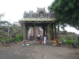
Kundrathur is a town located in the Chennai Metropolitan Area and the headquarters of Kundrathur taluk in Kanchipuram District. It is the birthplace of Sekkizhar, a well-known poet-saint who authored the Periyapuranam.

Manapakkam is a neighborhood in Chennai in the Indian state of Tamil Nadu. A census town, Manapakkam is located along the Mount-Poonamallee Road in Chennai. It is now a home to many Core sector companies, like ABB, Hitachi Energy, DLF Cybercity Chennai and Larsen & Toubro.
Pozhichalur is a census town in Chennai metropolitan city in the Indian state of Tamil Nadu. It is a suburb of Chennai and is located close to the Chennai Airport at Tirusulam on its south west side. It lies on the south banks of the Adyar River. Agasteeswarar Temple, which is called North Thirunallaru, is situated there. The neighborhood is served by Pallavaram Railway Station of the Chennai Suburban Railway Network.
Iyyappanthangal is a neighborhood to the west of Chennai, Tamilnadu, India. It comes under Mangadu Municipality of Chennai Metropolitan Area (CMA), governed by CMDA. It is located 20 kilometres (12 mi) away from Fort St George on the Mount-Poonamallee Road. The nearest railway stations are at Guindy about 11 kilometres (6.8 mi) away and Avadi about 12 kilometres (7.5 mi) away. The Porur Junction where a much-needed road overbridge on the busy Guindy–Poonamallee stretch was built after a very long delay of nearly five years is just about 2 km from Iyyapanthangal and the Poonamallee Junction is just about 6 km from the town.
Mugalivakkam is a neighbourhood of Chennai. It is located in Sriperumbudur taluk of Kanchipuram district, in Tamil Nadu. It is situated 16 km south-west of Chennai on the Mount-Poonamallee Road. It is bounded by Porur on the North Meenambakkam and Manapakkam on the South and South East, Madhanandhapuram and Gerugambakkam on the South West and Ramapuram on the North East directions. The nearest railway station is at Guindy which is about 6 kilometres away. Porur junction is around 2 km away and Kathipara Junction is around 5 km away.
Maraimalai Nagar is a municipality town in South Chennai at Chengalpattu district, Tamil Nadu, India. Lying in the southern part of the Chennai metropolitan area, it is a satellite town of Chennai, the state capital, around 50 km from Downtown Chennai (Egmore) and about 15 km from Vandalur. It was developed by the CMDA in 1980. Many heavy industries are located in Maraimalai Nagar. The Ford India and BMW car factories are located within a mile from Maraimalai Nagar and the Indian software giant Infosys also has an office within eight kilometers of Maraimalai Nagar. SRM University has its main campus in the neighboring Potheri. As of 2011, Maraimalai Nagar had a population of 81,872.
Alapakkam is a neighbourhood in western part of Central Chennai. It belongs to Central Chennai Revenue Division of Chennai district. It is surrounded by Porur, Valasaravakkam and Maduravoyal. It is part of Chennai corporation under zone 11. Entry into Alapakkam is through two main roads, that is, Arcot Road and Poonamallee High Road. Alapakkam belongs to Sriperumbudur Lok Sabha constituency and Maduravoyal assembly constituency.
Cowl Bazaar is a suburb of Chennai located in the Chengalpattu district of Tamil Nadu, India. It is a village panchayat in St.Thomas Mount Block located north of Pozhichalur and west of Chennai International Airport along the banks of Adyar River. It is located about 21 kilometres (13 mi) Marina Beach and 3 km (1.9 mi) Porur. It is located closer to other major suburban areas like Pammal, Pallavaram, Anakaputhur and Kundrathur. The neighborhood is served by Pallavaram railway station of the Chennai Suburban Railway Network. The Cowl Bazaar Bridge connects Pallavaram, Pammal and Pozhichalur with Kolapakkam, Porur, Moulivakkam and Manapakkam. The Pallavaram - Kolapakkam Road connects Pallavaram with Kolapakkam via Pammal and Pozhichalur runs along Cowl Bazaar.
Pallavaram–Kundrathur–Poonamallee Road or State Highway 113A is an arterial road in Chennai City connecting Grand Southern Trunk Road in Pallavaram with Trunk Road in Kumananchavadi in Poonamallee running for a length of 13 kilometres (8.1 mi). The road is also known as Pammal Main Road. The road runs through Pammal, Anakaputhur, Kundrathur, Mangadu and Kumanan Chavadi.


