Related Research Articles
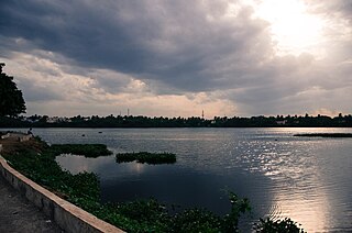
Kancheepuram district is one of the districts in the northeast of the state of Tamil Nadu in India. The area comprising the present day Kancheepuram district was earlier a part of Chingleput district. The original Chingleput district was split in the year 1997 to form the present day Kancheepuram and Tiruvallur districts.

Kanchipuram, also known as Kānchi or Kancheepuram, is a temple city in the Indian state of Tamil Nadu in Tondaimandalam region, 72 km (45 mi) from Chennai – the capital of Tamil Nadu. The city covers an area of 11.605 km2 (4.481 sq mi) and had a population of 164,265 in 2011. It is the administrative headquarters of Kanchipuram District. Kanchipuram is well-connected by road and rail. Chennai International Airport is the nearest domestic and international airport to the city, which is located at Tirusulam in Kanchipuram district.

Chennai district, formerly known as Madras district, is one of the 37 districts in the state of Tamil Nadu in India. It is the smallest and densest of all the districts in the state. Most of the Greater Chennai City comes under this district, erstwhile under Tiruvallur, Kanchipuram and Chengalpattu districts. As of 2011, the district had a population of 7,100,000 with a sex-ratio of 989 females for every 1,000 males.
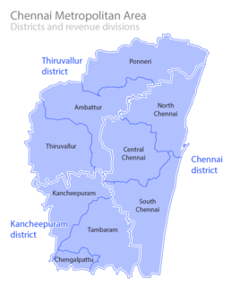
Metropolitan area includes a city and its suburbs. For the city, visit Chennai district

Brahmadesam is an Indian Panchayat, town panchayat village located in Cheyyar taluk of Thiruvannamalai district in the state of Tamil Nadu. It is one of the 64 village panchayats under Vembakkam block of the Thiruvannamalai district. Brahmadesam is located on Right Bank of Palar River. The village code for Brahmadesam is 07 and it falls under the Venbakkam Block.
Keezhacherry is a village in the Lattur revenue block of kanchipuram district, Tamil Nadu, India.
The Acharapakkam block is a revenue block in the Kanchipuram district of Tamil Nadu, India. It has a total of 59 panchayat villages.
The Kanchipuram block is a revenue block in the Kanchipuram district of Tamil Nadu, India. It has a total of 43 panchayat villages.
The Madurantakam block is a revenue block in the Kanchipuram district of Tamil Nadu, India. It has a total of 58 panchayat villages.
The Walajabad block is a revenue block in the Kanchipuram district of Tamil Nadu, India. It has a total of 61 panchayat villages.
The Chithamur block is a revenue block in the Kanchipuram district of Tamil Nadu, India. It has a total of 43 panchayat villages.
Kattangulathur block is a revenue block in the Kanchipuram district of Tamil Nadu, India. It has a total of 39 panchayat villages.
The Lathur block is a revenue block in the Kanchipuram district of Tamil Nadu, India. It has a total of 41 panchayat villages.
The Sriperumbudur block is a revenue block in the Kanchipuram district of Tamil Nadu, India. It has a total of 58 panchayat villages.
The Thirupporur block is a revenue block in the Kanchipuram district of Tamil Nadu, India. It has a total of 50 panchayat villages.
The Uttiramerur block is a revenue block in the Kanchipuram district of Tamil Nadu, India. It has a total of 73 panchayat villages.
Kanchipuram division is a revenue division in the Kanchipuram district of Tamil Nadu, India. It comprises the taluks of Kanchipuram, Sriperumbudur and Uthiramerur.
The Tirukalukundram block is a revenue block in the Chengalpattu district of Tamil Nadu, India. It has a total of 54 panchayat villages.
Tondaimandalam also known as Tondai Nadu is a historical region located in the southern part of Andhra Pradesh and northernmost part of Tamil Nadu. The region comprises the districts which formed a part of the traditional malayaman kingdom. The boundaries of Tondaimandalam are ambiguous – between the Rivers basins of Penna River and Ponnaiyar River.
References
- "Map of revenue blocks of Kanchipuram district". Government of Tamil Nadu. Archived from the original on 3 March 2016.
| District Headquarters | 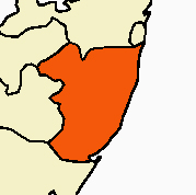 | |
|---|---|---|
| Country | ||
| State | ||
| Region | ||
| Taluks | ||
| Blocks | ||
| Municipal Corporations |
| |
| Municipalities | ||
| Special Grade Town Panchayats | ||
| Town Panchayats | ||
| History | ||
| Places of interest |
| |
| Religious and monastic institutions | ||
| Universities | ||
| This Kanchipuram district location article is a stub. You can help Wikipedia by expanding it. |