
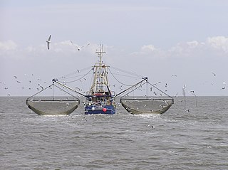
A fishing trawler is a commercial fishing vessel designed to operate fishing trawls. Trawling is a method of fishing that involves actively dragging or pulling a trawl through the water behind one or more trawlers. Trawls are fishing nets that are pulled along the bottom of the sea or in midwater at a specified depth. A trawler may also operate two or more trawl nets simultaneously.

Pulicat Lagoon is the second largest brackish water lagoon in India,, measuring 759 square kilometres (293 sq mi). The lagoon is one of the three important wetlands to attract northeast monsoon rain clouds during the October to December season in the Tirupati Region. The lagoon comprises the following regions, which adds up 759 square kilometres (293 sq mi) according to Andhra Pradesh Forest Department: 1) Pulicat Lake 2) Marshy/Wetland Land Region (AP) 3) Venadu Reserve Forest (AP) 4) Pernadu Reserve Forest (AP) The lagoon was cut across in the middle by the Sriharikota Link Road, which divided the water body into lagoon and marshy land. The lagoon encompasses the Pulicat Lake Bird Sanctuary. The barrier island of Sriharikota separates the lagoon from the Bay of Bengal and is home to the Satish Dhawan Space Centre. Major part of the lagoon comes under Nellore district of Andhra Pradesh.
The Cooum river is one of the shortest classified rivers draining into the Bay of Bengal. This river is about 72 km in length, flowing 32 km in the city of Chennai and the rest in rural part. The river is highly polluted in the urban area (Chennai). Along with the Adyar River running parallel to the south and the Kosasthalaiyar River, the river trifurcates the city of Chennai and separates Northern Chennai from Central Chennai.

Chennai Port, formerly known as Madras Port, is the second largest container port of India, behind Mumbai's Nhava Sheva. The port is the largest one in the Bay of Bengal. It is the third-oldest port among the 13 major ports of India with official port operations beginning in 1881, although maritime trade started much earlier in 1639 on the undeveloped shore. It is an artificial and all-weather port with wet docks. Once a major travel port, it became a major container port in the post-Independence era. An established port of trade of British India since the 1600s, the port remains a primary reason for the economic growth of Tamil Nadu, especially for the manufacturing boom in South India, and has contributed greatly to the development of the city of Chennai. It is due to the existence of the port that the city of Chennai eventually became known as the Gateway of South India.
A fishing vessel is a boat or ship used to catch fish in the sea, or on a lake or river. Many different kinds of vessels are used in commercial, artisanal and recreational fishing.

Fishing in India is a major industry employing 14.5 million people. India ranks second in aquaculture and third in fisheries production. Fisheries contributes to 1.07% of the Total GDP of India. According to the National Fisheries Development Board the Fisheries Industry generates an export earnings of Rs 334.41 billion. Centrally sponsored schemes will increase exports by Rs 1 lakh crore in FY25. 65,000 fishermen have been trained under these schemes from 2017 to 2020. Freshwater fishing consists of 55% of total fish production.
Indian National Center for Ocean Information Services (INCOIS) is an autonomous organization of the Government of India, under the Ministry of Earth Sciences, located in Pragathi Nagar, Hyderabad. ESSO-INCOIS was established as an autonomous body in 1998 under the Ministry of Earth Sciences (MoES) and is a unit of the Earth System Science Organization (ESSO). ESSO- INCOIS is mandated to provide the best possible ocean information and advisory services to society, industry, government agencies and the scientific community through sustained ocean observations and constant improvements through systematic and focussed research.

Fishing is a prehistoric practice dating back at least 40,000 years. Since the 16th century, fishing vessels have been able to cross oceans in pursuit of fish, and since the 19th century it has been possible to use larger vessels and in some cases process the fish on board. Fish are normally caught in the wild. Techniques for catching fish include hand gathering, spearing, netting, angling and trapping.
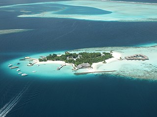
The fishing industry in the Maldives is the island's second main industry. According to national tradition in the words of former President Maumoon Abdul Gayoom, "Fishing is the lifeblood of our nation, it is inborn. From the soil on which we live, to the sea around us, it remains an integral part of our existence. Fishing, and our country and its people, [are] one and shall remain inseparable forever." The Maldives has an abundance of aquatic life and species of fish. Common are tuna, groupers, dolphin fish, barracuda, rainbow runner, trevally and squirrelfish and many more. Aside from being of essential importance to the economy, fishing is also a popular recreational activity in the Maldives, not only among locals but by tourists. The islands have numerous fishing resorts which cater for these activities.

The Adyar or Adayar, originating near the Chembarambakkam Lake in Kanchipuram district, is one of the three rivers which winds through Chennai (Madras), Tamil Nadu, India, and joins the Bay of Bengal at the Adyar estuary. The 42.5-kilometre (26.4 mi) long river contributes to the estuarine ecosystem of Chennai. Despite the high pollution levels, boating and fishing take place in this river. The river collects surplus water from about 200 tanks and lakes, small streams and the rainwater drains in the city, with a combined catchment area of 860 square kilometres (331 sq mi). Most of the waste from the city is drained into this river and the Cooum.
The Vizhinjam International Deepwater Multipurpose Seaport (U/C), also known as the Vizhinjam Port is an under construction port on the Arabian Sea coast at Vizhinjam in Thiruvananthapuram, Kerala, India. It will become the deepest port in India having natural draft depth of 24m. Developed in three phases, the first phase is expected to get completed by mid-2023. The initial date of completion was expected to be between December 2019 and August 2020. Delay in completion due to cyclones, coronavirus, environmental clearances etc. have resulted in legal disputes and arbitration.

Chetpet lake is a lake spread over 16 acres in Chetput, Chennai, India. It is located to the north of Chetpet railway station. It is the only existing lake at the centre of the city. The lake belongs to the Department of Fisheries of the Tamil Nadu government.

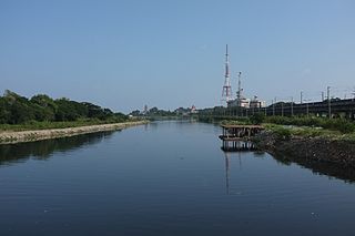
The North Chennai Thermal Power Station is a power station situated about 25 kilometres (16 mi) from Chennai city. It is one of the major power plants of Tamil Nadu and has a total installed capacity of 1,830 MW (2,450,000 hp).

The Port of Skagen, also Skagen Harbour, is located in Skagen, northern Denmark. The country's leading fishing port consists of an industrial harbour that supports the area's fishing industry as well as facilities for cruise ships. It also has a shipyard and fish-processing facilities. The harbour's marina is open to visitors during the summer months.

Chinnamuttom is a special-grade village in Kanyakumari District in the state of Tamil Nadu in India. Chinnamuttom is at the southernmost point of the Indian subcontinent. The nearest town is Kanyakumari, a special-grade township and an international tourist spot 1.5 km (1 mi) away. Nagercoil, the administrative headquarters of Kanyakumari District, is 24 km (15 mi) away.
Pallithottam is a neighbourhood of Kollam city situated at the coastal region. It is the 46th ward in Kollam Municipal Corporation. Pallithottam is totally depending on fishing activities and operations of Kollam Port.
The 2017 Ennore oil spill was an oil spill that occurred outside the Kamarajar Port in Ennore near Chennai in Tamil Nadu, India. The spill occurred on 28 January 2017 when an outbound empty tanker BW Maple collided with an inbound loaded oil tanker Dawn Kanchipuram at 04:00 local time. It was unexpected.

The Fishery Survey of India (FiSI), founded in 1983 by the Government of India's Ministry of Agriculture & Farmers Welfare, for the fisheries studies, research and survey of the traditional and deep sea fisheries of India within India's Exclusive economic zone, is tasked with the preparation of an annual Fishery Resources Survey and "Assessment and Research Programme" for the sustainable fishery requirements of traditional fishermen, small and medium boat operators and industrial fleet of deep-sea longlining tuna fishing.
Boxer Vadivelu was a fisherman and notorious gangster from Power Kuppam, Kasimedu. He started collecting extortion money from the markets at the Royapuram fishing harbour. He transported foreign liquor and goods from Kasimedu, Royapuram and Chennai harbour areas. He was involved in smuggling, contract killing and extortion. His gang attacked the office of the Tharasu magazine in 1991 and killed its employees. He got political patronage of All India Anna Dravida Munnetra Kazhagam. There was enmity between him and rival gangster Ayodhya Kuppam Veeramani after this incident.

The Yorkshire coast fishery has long been part of the Yorkshire economy for centuries. The 114 miles (183 km) Yorkshire Coast, from the River Tees to the River Humber, has many ports both small and large where sea catch was landed. The historic ports at Hull and Whitby are important locations for the landing and processing of fish and shellfish. Scarborough and Bridlington are also sites of commercial fishing.
