
Adambakkam is a neighbourhood of Chennai, India. It is primarily a residential locality situated in South Chennai. Adambakkam area comes under Velachery taluk and Alandur taluk, Chennai District of Chennai Corporation. Adambakkam is surrounded by areas namely, Alandur in the North-West, Nanganallur in the West, Madipakkam in the South, Velachery in the East and Guindy in the North. Earlier, one part of Adambakkam was under the direct governance of Chennai Corporation. From October 2011 onwards, the entire area was merged with the Chennai Corporation. Upon completion of the MRTS extension line, the neighbourhood will be served by Adambakkam railway station. Its Proximity to commercial localities like Velachery, accessible railway stations, Metro Stations and road transport routes makes Adambakkam an ideal choice of location to live.

Kotturpuram, also known as Kottur, is a neighbourhood in Chennai (Madras), Tamil Nadu, India and is situated in the Southern banks of the Adyar River. It is surrounded by Nandanam in the North and North-West, Adyar in the South-East, IIT Chennai and Guindy in the South and Little Mount in the South-West. The neighbourhood is served by Kotturpuram MRTS railway station. Centuries old Hindu temples, such as Perumal Koil and Ponniamman Koil are situated in Kottur.

Parangimalai is a small hillock in the Chennai district of Tamil Nadu, India, near the neighbourhood of Guindy and very close to Chennai International Airport. By extension, it is also the name of the neighbourhood surrounding the hillock.
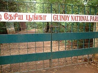
Guindy National Park is a 2.70 km2 (1.04 sq mi) protected area of Tamil Nadu, located in Chennai, India, is the 8th-smallest National Park of India and one of the very few national parks situated inside a city. The park is an extension of the grounds surrounding Raj Bhavan, formerly known as the 'Guindy Lodge', the official residence of the governor of Tamil Nadu, India. It extends deep inside the governor's estate, enclosing beautiful forests, scrub lands, lakes and streams.
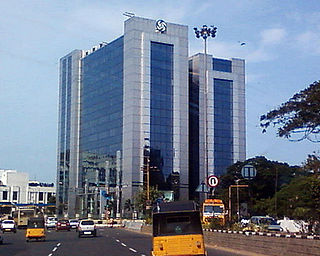
Guindy is a neighborhood of Chennai, Tamil Nadu. The Kathipara junction where Anna Salai, Mount-Poonamallee Road, Inner Ring Road, 100 Feet Road or Jawaharlal Nehru Road, and GST Road meet here. It is one of the important nodal points of road traffic in the metropolitan area. It is also a commercial hub. Here is headquarters of Ashok Leyland This junction serves as the entry point to the city limits from the suburbs. It is surrounded by Saidapet in the North, Kotturpuram and Adyar towards the East, Velachery in the South, Adambakkam and Alandur in the South-West, Parangimalai in the West and Ekkatutthangal in the North-West. Guindy is home to many important landmarks in the city, the most famous amongst them being the Guindy National Park. It also serves as a main hub for several small and medium scale industries. Transportation to/from the neighborhood is catered by Guindy railway station and Guindy metro station.
Velachery is a commercial and residential area in south Chennai and is the largest commercial centre in south Chennai. It is surrounded by Guindy in the north, IIT Madras in the north-east, Taramani in the east, Perungudi in the south-east, Pallikaranai Wetland in the south, Madipakkam in the south and south-west, Adambakkam in the west and north-west. The growth of the neighbourhood during the last decade can be cited due to the growth of the IT sector in south Chennai. It acts as an important hub connecting the rapidly growing business-class information technology corridor popularly called the OMR; the more mature and very well-connected GST road and the central business districts of the city, which has more relevance to the history of Chennai. Velachery as a whole draws a perfect balance between old and new Chennai and is a phenomenon in terms of growth and development.

Saidapet, also known as Saidai, is a neighbourhood in Chennai, India, situated in the northern banks of the Adyar River and serves as an entry point to Central Chennai. It is surrounded by West Mambalam in the North, C.I.T Nagar in the North-East, Nandanam in the East, Guindy in the South, Jafferkhanpet and Ashok Nagar in the North-West. The Saidapet Court, the only other court of judicature in Chennai city apart from the Madras High Court, and the Saidapet bus depot are located here. Prior to its incorporation in Madras city, Saidapet functioned as the administrative headquarters of Chingleput district. The neighbourhood is served by Saidapet railway station of the Chennai Suburban Railway Network.
Park Town is a neighbourhood in downtown Chennai, India. It lies adjacent to the historical neighbourhood of George Town. The area got its name from the People's Park which was situated near the Ripon Building. It was earlier known as White Town, as the Europeans used to stay here.
Perambur is a neighbourhood located in the northern region of Chennai, Tamil Nadu, India.
Ramapuram is a neighbourhood in the western part of Chennai, India. It is situated on the Mount-Poonamallee Road at a distance of 3 kilometres from Guindy. Ramapuram forms a part of Maduravoyal taluk, Chennai district. Ramapuram is located at an altitude of 42 m above the mean sea level with the geographical coordinates of 13.010600°N 80.193180°E.
Iyyappanthangal is a western neighborhood of Chennai, Tamilnadu, India. It comes under Mangadu Municipality of Chennai Metropolitan Area (CMA), governed by CMDA. It is located 20 kilometres (12 mi) away from Fort St George on the Mount-Poonamallee Road. The nearest railway stations are at Guindy about 11 kilometres (6.8 mi) away and Avadi about 12 kilometres (7.5 mi) away. The Porur Junction where a much needed road overbridge on the busy Guindy–Poonamallee stretch was built after a very long delay of nearly five years is just about 2 km from Iyyapanthangal and the Poonamallee Junction is just about 6 km from the town.

The Chennai Suburban Railway is a commuter rail system in the city of Chennai, Tamil Nadu, India, operated by the Southern Railways branch of Indian Railways. It is the second largest suburban rail network in terms of route length and the third largest in terms of commuters in India. Around 1,000 services are operated daily between 4:00 a.m. and midnight. It is the longest suburban circular route in India covering of 235.5 km (146.3 mi).

Anna Salai, formerly known as St. Thomas Mount Road or simply Mount Road, is an arterial road in Chennai, India. It starts at the Cooum Creek, south of Fort St George, leading in a south-westerly direction towards St. Thomas Mount, and ends at the Kathipara Junction in Guindy. Beyond the Kathipara Junction, a branch road arises traversing westwards to Poonamallee to form the Mount-Poonamallee Road while the main branch continuing southwards to Chennai Airport, Tambaram and beyond to form Grand Southern Trunk Road. Anna Salai, which is more than 400 years old, is acknowledged as the most important road in Chennai city. The head offices of many commercial enterprises and public buildings are located along Anna Salai. It is the second longest road in Chennai, after EVR Periyar Salai.

Chennai Park Town, or just Park Town, is a railway station on the Chennai MRTS. Located just to the east of Pallavan Salai and to the south of the Rajiv Gandhi Government General Hospital in the Park Town neighbourhood of Chennai, it exclusively serves the Chennai MRTS. The station is adjacent to Chennai Park, which serves the Chennai Suburban Railway. It is also within walking distance to Chennai Central. Although within walking distance, a 1 km overhead pedestrian walkway is being planned to connect Chennai Central with the MRTS station.

Arignar Anna Alandur Metro, commonly known as the Alandur Metro, is an elevated metro station that is part of the Blue Line and the Green Line of the Chennai Metro, and serves as an interchange station between the two lines. The station is one of the two metro stations where the two lines intersect, the other being the Chennai Central metro station. It is the city's first multi-level railway station. It is the only station where passengers from the two corridors can swap the direction of travel. On 31 July 2020, It has been named by Government of Tamil Nadu as Arignar Anna Alandur Metro to honor the DMK founder and the former Chief Minister of Tamil Nadu C. N. Annadurai.
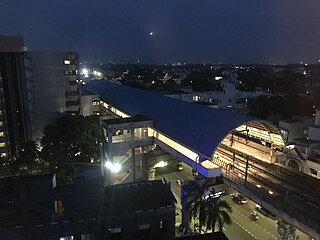
Guindy is an elevated metro station on the North-South Corridor of the Blue Line of Chennai Metro in Chennai, India, which opened on 21 September 2016. This station will serve the neighbourhoods of Guindy and Velachery.

Arumbakkam is an elevated metro station on the South-East Corridor of the Green Line of Chennai Metro in Chennai, India. This station will serve the neighbourhoods of Vinayagapuram, Choolaimedu and MMDA Colony.

Ekkattuthangal is an elevated metro station on the South-East Corridor of the Green Line of Chennai Metro in Chennai, India. This station will serve the neighbourhoods of Ekkattuthangal, West Mambalam, Guindy Industrial Estate and West Saidapet.
Guindy taluk is a taluk of the city district of Chennai in the Indian state of Tamil Nadu. It was formed in December 2013 from parts of the erstwhile Mambalam-Guindy taluk and the Mylapore-Triplicane taluk. It comprises the neighbourhoods of Adyar, Alandur, T. Nagar, Ekkaduthangal, Guindy and Kotturpuram.
Guindy, is located in north west part of Chennai City.


