For the film named after this place, see Vada Chennai.
North Chennai is a geographic term used to refer to the northern part of Chennai city. Though its definition has varied with time and context, it is generally accepted among historians that North Chennai is used for the part of Chennai city situated north of the Coovum River.[1] Encompassing the Fort St George and Georgetown areas from which the city originated, North Chennai is generally considered an area of stagnant growth, but now it is developing that has already reached saturation as a real estate choice.[2] The area is generally notorious for its thick population, narrow roads, poor infrastructure,[3][4] and high incidence of crime.[2][5][6] This characterization is, however, limited to older neighbourhoods close to the sea coast as new areas to the west, like Kilpauk, Anna Nagar, Avadi and Ambattur have good standards of living and acquired desirability as residential areas.
Northwards of Georgetown, extends the Anglo-Indian settlement of Royapuram and the historical town of Thiruvottiyur beyond which North Madras gives way to a series of fishing hamlets, individually known as kuppam in Tamil. The Red Hills region is known for the Pulhal Lake and the central prison. The port of Ennore located 16 kilometres supplements Chennai Port as a major entrepot for trading vessels. Northwards lie Minjur, Ennore and Thiruvottiyur. Westwards lie the industrial suburbs of Padi, AmbatturAvadi and Thiruninravur. The head office will be at Tondiarpet, was comprise Tiruvottiyur, Tondiarpet, Madhavaram, Perambur and Purasawalkam taluks.
History
North Chennai originated with the founding of an East India Company factory in the village of Madrasapatnam. The grant was confirmed on 22 August 1639 which is generally considered the date of the city's founding and celebrated as Madras Day and the signatories were Francis Day for the East India Company and Damera Venkata Nayaka a Padmanyaka Velama ruler for the Vijayanagar Empire. The construction of a small fort was started in 1640 and completed by 1652. This would, by the end of the 18th century, with significant alterations and expansions, become the Fort St George that we know today. Prior to the city's founding, fishing hamlets existed in the area.
Georgetown remained a fashionable residential area till the early 1900s when congestion and lack of cleanliness compelled people to look for areas further south. It was also Chennai's Central business district till the 1950s when it was supplanted by T. Nagar.
Avadi is a western suburb of Chennai, and the headquarters of Avadi taluk located within the Thiruvallur district of Tamil Nadu, India. Situated at about 22 kilometres (14 mi) from Chennai Central Railway Station, it is one of the four municipal corporations in the Chennai Metropolitan Area and is governed by the Avadi Municipal Corporation. It is surrounded by major defence establishments and is home to various universities and engineering colleges. The neighborhood is served by Avadi Railway Station of the Chennai Suburban Railway and just 7 km from the upcoming Karayanchavadi Metro of Chennai Metro Rail. As of 2011, Avadi had a population of 345,996, which is 10th most populous place in Tamil Nadu. It is home to the Heavy Vehicles Factory (HVF), Ordnance Factory Board (ODF) which houses Engine Factory and Combat Vehicles Research and Development Establishment (CVRDE). The lake in Avadi was known as Paaleripattu, which is now found only in very old land documents.
Transport in Chennai includes various modes of air, sea, road and rail transportation in the city and its suburbs. Chennai's economic development has been closely tied to its port and transport infrastructure, and it is considered one of the best infrastructure systems in India.
Ambattur is a northwestern part of Chennai, India. It is located in Ambattur taluk of the Chennai District, surrounded by Avadi, Anna Nagar, Korattur, Padi, Mogappair, Kallikuppam, Surapet, Ayappakkam, Athipet and Thiruverkadu. It covers an area of 40.36 km2 (15.58 sq mi). The neighbourhood is served by Ambattur railway station of the Chennai Suburban Railway. Ambattur has its origins in a village of the same name which can be located at present as areas opposite to Ambattur telephone exchange. Ambattur was a village with large extents of agricultural farm lands irrigated by the once-sprawling Ambattur Lake. In 2011, the neighborhood had a population 466,205.
Pulhal Lake, or Pulhal aeri, sometimes spelled Puzhal lake and also known as the Red Hills Lake, is located in Red Hills, Chennai, India. It lies in Thiruvallur district of Tamil Nadu state. It is one of the two rain-fed reservoirs that supply water to Chennai City, the other one being the Chembarambakkam Lake and Porur Lake.
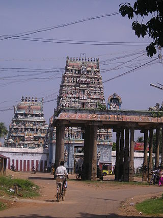
Tiruvottriyur is a neighbourhood in North Chennai, administered by the Greater Chennai Corporation. It is part of the Tondiarpet division, located to the north of Chennai. It is one of the fifteen administrative zones in the Greater Chennai Corporation. The zone is called Zone 1 (Tiruvottriyur).
Padi is a locality and neighbourhood in the city of Chennai, India. It was named as Thiruvaaipadi and Later called as Padi short form of Thiruvaaipadi, Sundarar, came to Padi and sang songs in the Lord Shiva Temple. Padi exactly 13 km from the city's Kilometer Zero is a latest included part of the city. MTH Road, now unofficially known as the CTH Road, passes through Padi. Padi is basically an industrial area and its infrastructure and living conditions have made this place popular among the working class. Arulmigu Thiruvalithayam Temple in Padi is one of the famous Guru Bhagawan temples in Chennai. This temple is under the control of Hindu Aranilayathurai. Every year Thai Kirthigai is one of the big festival in Padi. Another nearby temple is the Padavattamman Temple.
The Chennai Suburban Railway is a commuter rail system in the city of Chennai, Tamil Nadu, India, operated by the Southern Railways branch of Indian Railways. It is the second largest suburban rail network in terms of route length and the third largest in terms of commuters in India. Around 1,000 services are operated daily between 4:00 a.m. and midnight. It is the longest suburban circular route in India covering of 235.5 km (146.3 mi).
The Chennai Metropolitan Development Authority (CMDA), formerly known as the Madras Metropolitan Development Authority (MMDA), is the nodal planning agency of Chennai in the Indian state of Tamil Nadu. The CMDA administers the Chennai Metropolitan Region, spread over an area of 5,904 km2 (2,280 sq mi) and covers the districts of Chennai, Thiruvallur, Chengalpattu, Ranipet and Kancheepuram. It was set up for the purposes of planning, co-ordination, supervising, promoting and securing the planned development of the Chennai Metropolitan Area. It coordinates the development activities of the municipal corporations, municipalities and other local authorities.
Chennai is located at 13.04°N 80.17°E on the southeast coast of India and in the northeast corner of Tamil Nadu. It is located on a flat coastal plain known as the Eastern Coastal Plains. The city has an average elevation of 6 metres (20 ft), its highest point being 60 m (200 ft). Chennai is 2,184 kilometres south of Delhi, 1,337 kilometres southeast of Mumbai, and 1,679 kilometers southwest of Kolkata by road.
Thirumullaivoyal is a western neighbourhood of Chennai the capital of the India state of Tamil Nadu, under Avadi City Municipal Corporation Limits. It is located in the Chennai Metropolitan Area in Thiruvallur district, 3 km (1.9 mi) from Avadi and 3 km (1.9 mi) from Ambattur O.T Bus depot. The neighbourhood is served by Thirumullaivoyal railway station and Annanur Railway Station. The region was historically part of Thondaimandalam, a region in Chola Empire during 9th century CE.
Annanur is a western neighbourhood of Chennai, India. It is located near Ambattur and lies in Chennai District. It comes under the Avadi Municipal Corporation. It is located about 20 km from the city centre.
Nandiambakkam is a suburb in northern part of Chennai, Tiruvallur district, Tamil Nadu, India. It is a northern part of Chennai city. It has a population of around 17,000 people. The neighbourhood is served by Nandiambakkam railway station, of the Chennai Suburban Railway Network, and the following MTC bus services: Minjur–Madras High court, Minjur-Ennore, and Minjur-CMBT.
Ennore, also spelt Eṇṇūr, is a neighbourhood in Chennai, India. Ennore is situated on a peninsula and is bounded by the Korttalaiyar River, Ennore Creek and the Bay of Bengal. The creek separates south Ennore from the north Ennore which covers major portions of North Chennai Thermal Power Station and Ennore Port. The neighbourhood is served by Ennore railway station. Over the years Ennore has become the hub of a range of industrial projects, mainly thermal power stations, fertilizer factories, industrial ports and coal yards.
Mogappair is a residential neighborhood in north-western Chennai, India. It is located west of the Jawaharlal Nehru Road and is part of the Ambattur zone (7) of the Greater Chennai Corporation. There are industrial estates to the north and west, namely, Padi and Ambattur. Mogappair is located 4 km from Anna Nagar, 8 km from Avadi and 5 km from Ambattur.
Pudur is a locality in Chennai, Ambattur, which is a large neighbourhood in Chennai City.
Ayappakkam is a Western suburb of Chennai in Thiruvallur district in the Indian state of Tamil Nadu. Ayapakkam is currently a village panchayat surrounded by Thiruverkadu municipality, Avadi corporation and Greater Chennai Corporations.
Kallikuppam is a locality in Ambattur, which is a large neighbourhood in Chennai City.
Sembium is a Neighbourhood in Chennai, near to Perambur and a developed residential area in North Chennai, a metropolitan city in Tamil Nadu, India, located at an altitude of 9 m above mean sea level. Sembium was a municipality until it was annexed by Chennai. Sembium Post office is situated in Teeds Garden fourth street. Sembium Police station is located on Paper Mills road.
Tiruvottiyur taluk is a taluk of the city district of Chennai in the Indian state of Tamil Nadu. The centre of the taluk is the neighbourhood of Tiruvottiyur. The headquarters of the taluk is Tondiarpet division.
This page is based on this Wikipedia article Text is available under the CC BY-SA 4.0 license; additional terms may apply. Images, videos and audio are available under their respective licenses.