
Chengalpattu, previously known as Chingleput, is a town and the headquarters of Chengalpattu district of the state Tamil Nadu, India. The town is located near to the industrial and IT hub. It is the headquarters of the district and is 56 kilometres (35 mi) away from the state capital, Chennai on the National Highway 45.

Tiruvallur is a Grade I municipality in the Indian state of Tamil Nadu. It is located on the banks of Coovum river about 46 km (29 mi) from downtown Chennai (Madras) and just 5 km from megacity border, in the western part of the Chennai Metropolitan Area (CMA). It is a satellite town of Chennai and is the administrative headquarters of Tiruvallur District. The town is known for the Veeraraghava Swamy Temple, one of the 108 sacred shrines of Vaishnavites. The tank festival is held at a pond near this temple. A Shiva temple near this shrine which is popular among the locals. There is also a 40-foot (12 m) tall Viswaroopa Panchamukha Hanuman temple, where the murti is made of a single green granite stone.
Ambattur is a northwestern neighbourhood of Chennai, India. It is located in Ambattur taluk of the Chennai District, surrounded by Avadi, Anna Nagar, Korattur, Padi, Mogappair, Kallikuppam, Surapet, Ayappakkam, Athipet and Thiruverkadu. It covers an area of 40.36 km2 (15.58 sq mi). The neighbourhood is served by Ambattur railway station of the Chennai Suburban Railway. Ambattur has its origins in a village of the same name which can be located at present as areas opposite to Ambattur telephone exchange. Ambattur was a village with large extents of agricultural farm lands irrigated by the once-sprawling Ambattur Lake. In 2011, the neighborhood had a population 466,205.
Sullurupeta is a town in Tirupati district of Andhra Pradesh, India. It is a municipality and the headquarters of Sullurpeta mandal and Sullurupeta revenue division. It serves as a gateway to Satish Dhawan Space Centre(SDSC) at Sriharikota.

Sholinghur is a municipality under Sholinghur taluk in Ranipet District of Tamil Nadu, India. The town is famous in Tamil Nadu and other neighboring states for the Lakshmi Narasimha Swamy temple.

Poonamallee is a town and suburb of Chennai, India under the Chennai Metropolitan Area. It was historically called Pushpagirimangalam, later renamed in Tamil as Poovirundhavalli, and now colloquially called as Poondhamalli. It is the headquarters of the Poonamallee taluk of the Tiruvallur district in the Indian state of Tamil Nadu. The nearest Railway station is at Avadi. It acts as the gateway to the city from its western side. It is a town with rich cultural heritage and also a fast-growing areas in the city. As of 2011, the town had a population of 57,224. There are plans to merge the areas under Poonamallee Municipality with Avadi Municipal Corporation.
Singampunari is a Taluk in Sivagangai district, in Tamil Nadu, India. The town is located at a distance of 44 km from Karaikudi. The town comes under Singampunari taluk.

Oddanchatram is town in the Dindigul district of Tamil Nadu. The town was carved out of Madurai District in 1985. Oddanchatram has the second largest Vegetable market in Tamil Nadu and a large Cattle market. As of 2011, the town had a population of 30,064. It is known as the vegetable city of Tamil Nadu. Almost 70% of the vegetables from this market is sent to Kerala and remaining is sent to other states. Agriculture is the major economy for the town. The town was once a small village under the Aanda Nadu. This constituency, along with Palani, is historically a part of the Kongu region and distinguishes itself from the rest of the district in terms of culture and food.

Gummidipoondi is an industrial town in Chennai Metropolitan Region of Thiruvallur district in the Indian state of Tamil Nadu. Notably, it is the northernmost assembly constituency and settlement in the state of Tamil Nadu.
Kaveripakkam is a town panchayat in Ranipet district in the Indian state of Tamil Nadu.
Madhavaram is a neighbourhood of Chennai, Tamil Nadu, India. Located in the northern part of Chennai, it is also a taluk in Chennai District and a zone in Greater Chennai Corporation. It is located in between Perambur and Kodungaiyur. As of 2011, the neighbourhood had a population of 119,105. The Chennai district was expanded on 16 August 2018 by transferring Madhavaram taluk from Tiruvallur district to Chennai district.

Polur is a scenic town and a Religious site for Lord Narasimha called Sampathgiri, divisional headquarters and a market center in Tiruvannamalai district of Tamil Nadu in India. Located at the foothills of Javvadhi hills, a popular section of Eastern Ghats, Polur is often regarded as Gateway of Eastern ghats. Polur was once an eminent center of Tamil Jainism. The town is home to Dharani sugars, chemicals and fertiliser Pvt., Ltd, and number of agro based industries including coir industries. The famous Chittor - Cuddalore road passes through the town. The town is located 29 Kilometres north of city of Tiruvannamalai and 45 kilometres south of Vellore Metropolis.
Vandalur is a census town and taluk headquarters in the Chengalpattu district lying south of the metropolitan city of Chennai, India. Vandalur serves as the southern gateway to Chennai city. It has the Arignar Anna Zoological Park, which contain some rare species of wild flora and fauna. The town is served by Vandalur railway station of the Chennai Suburban Railway network.

Pakala is a town in Tirupati district of the Indian state of Andhra Pradesh. It is the mandal headquarters of Pakala mandal. It comes under Tirupati revenue division.

National Highway 16 is a major National Highway in India that runs along east coast of West Bengal, Odisha, Andhra Pradesh, and Tamil Nadu. It was previously known as National Highway 5.
Arambakkam is a village in the Tiruvallur district of Tamil Nadu, India. It is located in the Gummidipoondi taluk.
Pattabiram is a neighbourhood situated on the western part of Chennai, India. The suburb, which falls under Avadi Municipal Corporation, is about 25 km from the Chennai Central railway station.
Manellore is a village in the Tiruvallur district of Tamil Nadu, India. It is located in the Gummidipoondi taluk.
R.M.K. College of Engineering and Technology (RMKCET) is an engineering college in the village of Puduvoyal, in the municipality of Thiruvallur, in the Indian state of Tamil Nadu. It is governed by the Lakshmikanthammal Educational Trust, affiliated with Anna University, Chennai, and approved by AICTE. It is a Telugu minority institution. It is accredited by NAAC with A grade. It is also ISO 9000-2015 certified institution.
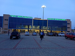
Madhavaram Mofussil Bus Terminus is a bus terminus in Chennai, India, located in the neighbourhood of Madhavaram, providing outstation/inter-state transport services. Spread over an area of 8 acres (32,000 m2), it was built to decongest the Chennai Mofussil Bus Terminus in Koyambedu. It will chiefly handle buses to Andhra Pradesh and Telangana, including cities such as Chittoor, Tirupati, Nellore, Vijayawada, Kurnool, Puttaparthi, Visakhapatnam, Bhadrachalam, and Hyderabad. As of 2018, the number of passengers travelling from Chennai to these two states daily average 12,500. The Tamil Nadu and Andhra governments operate about 315 services daily, with the number increasing during weekends.

