
Mandya is a city in the state of Karnataka. It is the headquarter of Mandya district and is located 45 kilometres (28 mi) from Mysore and 100 kilometres (62 mi) from Bangalore.
Kanchipuram district is one of the 38 districts in the state of Tamil Nadu in India. The area comprising the present day Kancheepuram district was earlier a part of Chingleput district. The original Chingleput district was split in 1997 into form the present day Kanchiepuram and Tiruvallur districts.
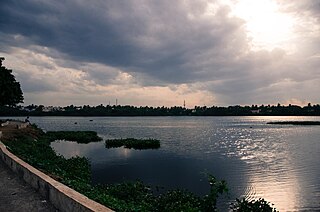
Perungudi is a neighbourhood of Chennai in the state of Tamil Nadu, India. It is situated about 10 kilometres (6.2 mi) south of Adyar. It is bordered on two sides by the Old Mahabalipuram Road and the Perungudi lake. It is situated on the Old Mahabalipuram IT Expressway right in middle of an Information Technology (IT) Estate. It is between Taramani and Thoraipakkam and parallel to Kottivakkam and Palavakkam in the East Coast Road.

Vellore district is one of the 38 districts in the Tamil Nadu state of India. It is one of the eleven districts that form the north region of Tamil Nadu. Vellore city is the headquarters of this district. As of 2011, the district had a population of 1,614,242 with a sex ratio of 1,007 females for every 1,000 males. In 2017 Vellore district ranked eleventh in list of districts in Tamil Nadu by Human Development Index.

Umaria is a municipality city in the Umaria district of the Shahdol Division of Madhya Pradesh, India.
Alandur is a zone of Chennai corporation, and an urban node in Chennai district in Guindy division in the state of Tamil Nadu, India. It is surrounded by Guindy in the north and east, Adambakkam in the south, Pazhavanthangal in the south-west and Parangimalai in the north-west. As of 2011, Alandur had a population of 164,430. The town agglomeration of Alandur will have an estimated population of 300,000 by 2030. Alandur neighbours the St. Thomas Mount Cantontment, the Officers Training Academy of the Indian army and the nearby towns of Guindy and Adambakkam. M. G. Ramachandran, a former chief minister of Tamil Nadu started his political career by winning his first legislative election from Alandur in 1967. Alandur also holds famous landmarks of Chennai namely Nehru Statue and Kathipara Junction.
Puzhuthivakkam, commonly known as Ullagaram or Ullagaram–Puzhuthivakkam, is a southern neighbourhood of Chennai in Tamil Nadu, India. Puzhuthivakkam loosely translates to dust neighborhood. The neighbourhood is part of the Greater Chennai Corporation, following Chennai's expansion into Kanchipuram district. Puzhuthivakkam is located between the neighborhoods of Madipakkam, Adambakkam, Velachery, Pallikaranai, and Nanganallur. Puzhuthivakkam was initially developed in the late 1960s and early 1970s. Upon completion of the MRTS extension line, the neighborhood will be served by Puzhuthivakkam railway station. As of 2011, the town had a population of 53,322.
Ayakudi is a panchayat town in Dindigul district in the state of Tamil Nadu, India. Ayakudi is thought to be the place where the kings of Ay Kingdom originated. The city is known for guava. It is filled with nature in the slopes of Kodaikanal.
Chinnasekkadu is a neighbourhood of Chennai in Chennai district in the state of Tamil Nadu, India. Chinnasekkadu used to be a town panchayat in Thiruvallur district. In 2011, Chinnasekkadu town panchayat was merged with Chennai Corporation. Chinnasekkadu comes under ward 29 in Zone 3(Madhavaram) of Chennai Corporation.

Injambakkam is a locality in the south of Chennai in the Indian state of Tamil Nadu. Being a part of the Walajabad block of the district, its panchayat is part of Walajabad panchayat union. Injambakkam is located along the ECR.
Katthivakkam is an residential and industrial area located in the northern part of Chennai. It is a part of zone 1 in Greater Chennai Corporation. It is under Thiruvottiyur taluk in Chennai district. It is a part of Thiruvottiyur(state assembly constituency) and Chennai North. Formerly a town and a municipality of Thiruvallur district in the Indian state of Tamil Nadu, it has now been absorbed by Chennai city in September 2011 and within Chennai District limit since January 2018. The neighbourhood is served by Katthivakkam railway station. As of 2011, the town had a population of 36,617.
Komaralingam is a town located in the Tiruppur district of Tamil Nadu, India. It is located at a distance of 8 km from Madathukulam, 16 km from Udumalaipettai, 22 km from Palani, 85 km from Coimbatore and 79 km from Tiruppur.
Kottivakam is a locality in the south of Chennai in Chennai district in the Indian state of Tamil Nadu. Kottivakkam is included with the Chennai Corporation.

Manapakkam is a neighborhood in Chennai in the Indian state of Tamil Nadu. A census town, Manapakkam is located along the Mount-Poonamallee Road in Chennai. It is now a home to many Core sector companies, like ABB, Hitachi Energy, DLF Cybercity Chennai and Larsen & Toubro.
Nandivaram-Guduvancheri is a municipality located in Chennai Metro City in Chengalpattu district in the Indian state of Tamil Nadu. It is lies in the southern part of Chennai metropolitan area.
Shahganj is a town and a municipal board in Jaunpur district in the Indian state of Uttar Pradesh.
Tiruvottriyur is a neighbourhood in North Chennai, administered by the Greater Chennai Corporation. It is part of the Tondiarpet division, located to the north of Chennai. It is one of the fifteen administrative zones in the Greater Chennai Corporation. The zone is called Zone 1 (Tiruvottriyur).

Udumalai, also known as Udumalaipettai and Udumalpet, is a town in Tiruppur district in the Indian state of Tamil Nadu. It is located 535 km south west from the state capital, Chennai and 72 km from Coimbatore. It is the headquarters of Udumalaipettai taluk and had a population of 61,133 as per 2011 Census of India. The town comes under the Udumalaipettai Assembly constituency.

Kovilambakkam is a southern suburb of Chennai, India. It is a village panchayat located in Tambaram taluk, Chengalpattu district in the state of Tamil Nadu, about 26 km from Chennai city center and 12 km from Tambaram. The neighbourhood spans the areas of Sunnambu Kolathur, Chinna Kovilambakkam and Periya Kovilambakkam.

Tirupathur or Tirupattur is the headquarters of Tirupathur district in the state of Tamil Nadu in India and is one of the oldest inhabited places in the state, with a history of over 1,600 years. The town is known for an abundance of sandalwood in the surrounding hills. It is located about 89 km (55 mi) from Vellore, 85 km (53 mi) from Hosur, 60 km (37 mi) from Dharmapuri, 50 km (31 mi) from Krishnagiri, 50 km (31 mi) from Thiruvannamalai, 279 km (173 mi) from coimbatore, 210 km (130 mi) from Chennai, and 125 km (78 mi) from Bangalore.


