Mylapore, or Thirumayilai, is a neighbourhood in the central part of the city of Chennai, India. It is one of the oldest residential parts of the city. The locality is claimed to be the birthplace of the celebrated Tamil philosopher Valluvar, and the Hindu saint and philosopher, Peyalvar.

Thyagaraya Nagar, commonly known as T. Nagar, and historically known as East Mambalam, is a very affluent commercial and residential neighbourhood in Chennai, Tamil Nadu, India. It is surrounded by Nungambakkam in the North, Teynampet in the East, Nandanam in the South-East, C.I.T. Nagar in the South and West Mambalam and Kodambakkam in the West. The stretch between Duraiswamy Road and T. Nagar Bus Stand has some of the costliest real estates in Chennai. It was constructed between 1923 and 1925 by the Madras Presidency government of the Raja of Panagal as a part of town planning activities initiated according to the Madras Town Planning Act of 1920. The town was named after P. Thyagaraya Chetty. The streets, parks and localities in the new neighbourhood were named after important officials in the provincial government.
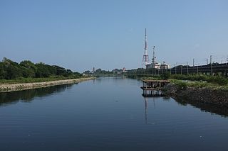
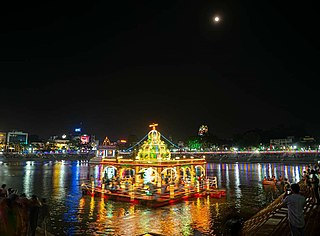
The Cooum river, or simply Koovam, is one of the shortest classified rivers draining into the Bay of Bengal. This river is about 72 km (45 mi) in length, flowing 32 km (20 mi) in the city of Chennai and the rest in rural part. The river is highly polluted in the urban area (Chennai). Along with the Adyar River running parallel to the south and the Kosasthalaiyar River, the river trifurcates the city of Chennai and separates Northern Chennai from Central Chennai. It is also sometimes known as Thiruvallikenni river

Anna Nagar, is a neighbourhood in the metropolitan city of Chennai, India. Named after former chief minister of Tamil Nadu C. N. Annadurai, it is located in the north-western part of Chennai and forms a part of the Aminjikarai taluk and the Anna Nagar Zone. It is one of the prime residential areas in Chennai and is home to several prominent doctors, lawyers and politicians. Real estate prices are among the highest in the city. A recent addition to the area is VR Chennai Mall, located near Shanthi Colony and Thirumangalam junction.

Thiruvallikeni known as Triplicane, is one of the oldest neighbourhoods of Chennai, India. It is situated on the Bay of Bengal coast and about 0.6 km (0.37 mi) from Fort St George. The average elevation of the neighbourhood is 14 metres above sea level.

Chepauk is a locality in Chennai, India. The name Chepauk is popularly used to refer to the M. A. Chidambaram International Cricket Stadium, also known as the Chepauk Stadium. It is also home to the Chepauk Palace, built in the Indo-Saracenic style. The University of Madras campus is yet another prominent landmark of Chepauk. The Central Research laboratory is located here. Chepauk's postal index number (PIN) code is 600005. The main roads of Chepauk are Bells Road and Walajah Road.

Saidapet, also known as Saidai, is a neighbourhood in Chennai, India, situated in the northern banks of the Adyar River and serves as an entry point to Central Chennai. It is surrounded by West Mambalam in the North, C.I.T Nagar in the North-East, Nandanam in the East, Guindy in the South, Jafferkhanpet and Ashok Nagar in the North-West. The Saidapet Court, the only other court of judicature in Chennai city apart from the Madras High Court, and the Saidapet bus depot are located here. Prior to its incorporation in Madras city, Saidapet functioned as the administrative headquarters of Chingleput district. The neighbourhood is served by Saidapet railway station of the Chennai Suburban Railway Network.
Meenambakkam is a southern neighbourhood of Chennai in the Indian state of Tamil Nadu. It is home to Chennai International Airport, the Airports Authority of India regional office, and the DGQA Complex. It was under the reign of the Pallava kingdom. The name Meenambakkam signifies that it is a settlement near the coast. Pakkam means a settlement near to the coast. Meenambakkam was cherished with lakes, ponds and borderlines the Adyar river. This makes it a rich source of fishes. Hence the name Meenambakkam was coined.
Park Town is a neighbourhood in downtown Chennai, India. It lies adjacent to the historical neighbourhood of George Town. The area got its name from the People's Park which was situated near the Ripon Building. It was earlier known as White Town, as the Europeans used to stay here.

Chennai architecture is a confluence of many architectural styles. From ancient Tamil temples built by the Pallavas, to the Indo-Saracenic style of the colonial era, to 20th-century steel and chrome of skyscrapers. Chennai has a colonial core in the port area, surrounded by progressively newer areas as one travels away from the port, punctuated with old temples, churches and mosques.
Aminjikarai, originally Amaindakarai, is one of the oldest neighbourhoods in Chennai, Tamil Nadu, India. The arterial Poonamallee High Road runs through it. Aminjikarai was annexed to Madras District in the year 1946, and Arumbakkam and Anna Nagar were carved out of Aminjikarai in the 1950s and 1970s. The Nelson Manickam Road that traverses through Aminjikarai is an important commercial road in Chennai city.
Sengundram, known in English as Red Hills, is a neighbourhood in the northwestern part of Chennai, Tamil Nadu, India. The name was derived from the red hills that was formerly present in the area.

Anna Salai, formerly known as St. Thomas Mount Road or simply Mount Road, is an arterial road in Chennai, India. It starts at the Cooum Creek, south of Fort St George, leading in a south-westerly direction towards St. Thomas Mount, and ends at the Kathipara Junction in Guindy. Beyond the Kathipara Junction, a branch road arises traversing westwards to Poonamallee to form the Mount-Poonamallee Road while the main branch continuing southwards to Chennai Airport, Tambaram and beyond to form Grand Southern Trunk Road. Anna Salai, which is more than 400 years old, is acknowledged as the most important road in Chennai city. The head offices of many commercial enterprises and public buildings are located along Anna Salai. It is the second longest road in Chennai, after EVR Periyar Salai.
Ayanpuram or Ayanavaram is a neighbourhood in Chennai, India. Konnur High Road, one of the important connecting roads in Chennai runs through Ayanavaram.

George Town is a neighbourhood in Chennai, Tamil Nadu, India. It is near the Fort Saint George, Chennai. It is also known as Muthialpet and Parry's corner. It is an historical area of Chennai city from where its expansion began in the 1640s. It extends from the Bay of Bengal in the east to Park town on the west. The Fort St. George is on the south, to Royapuram in the north. The Fort St. George houses the Tamil Nadu Legislative Assembly and the Secretariat. The High court of Tamil Nadu at Chennai, Dr. Ambedkar Law College, Stanley Medical College and Hospital are located here.
Queenship of Mary Church parish in Chintadripet, Chennai, India, was started in 1904 when it was known as St. Lazarus Church. Earlier, it had been a sub-station of St. Anthony's Church, Pudupet. A new church was built in 1952 with the name Queenship of Mary; it was consecrated on 18, December 1955 by Auxiliary Bishop Francis Arthur Carvalho, of Madras and Mylapore. Under the supervision of Reverend M. V. Jacob, a new church was constructed on 1 October 2003. A grotto was built in commemoration of the centenary celebrations in 2004.
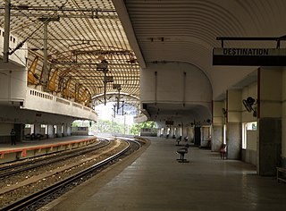
Chintadripet is a railway station on the Chennai MRTS line. It was opened in November 1995. It is built on the bank of Cooum River alongside Arunachala Street, opposite the new secretariat building. The station will be connected with the Chennai Metro Government Estate station, which is currently under construction. The station building contains a 1150 square metres parking area in its lower level.
Kurungaleeswarar Temple is a historically important Hindu temple in the neighbourhood of Koyambedu, Chennai, India. The temple encloses a large tank and dates from the Medieval Chola period.
Kadambathur, also spelt Kadambattur, is a town located in Tiruvallur district in the Indian state of Tamil Nadu. It is a census town in Tiruvallur taluk. According to the 2011 census, the town has a population of 11,235.

Royapettah is a neighbourhood of Chennai, India.


