"Urban development" redirects here. For actual development, see urbanization. For negative effects, see urban sprawl.
"Development planning" redirects here. For proposals setting out a local authority's policies and proposals for land use, see Development plan. For planning for personal development, see Personal development planning.
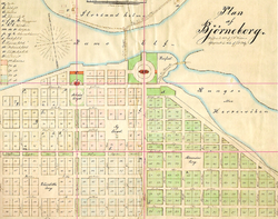
Partizánske in Slovakia – an example of a typical planned European industrial town founded in 1938 together with a shoemaking factory in which practically all adult inhabitants of the city were employed
Urban planning (also called city planning or town planning in some contexts) is the process of developing and designingland use and the built environment, including air, water, and the infrastructure passing into and out of urban areas, such as transportation, communications, and distribution networks, and their accessibility.[1] Traditionally, urban planning followed a top-down approach in master planning the physical layout of human settlements.[2] The primary concern was the public welfare,[1][2] which included considerations of efficiency, sanitation, protection and use of the environment,[1] as well as taking account of effects of the master plans on the social and economic activities.[3] Over time, urban planning has adopted a focus on the social and environmental "bottom lines" that focuses on using planning as a tool to improve the health and well-being of people and maintain sustainability standards. In the early 21st century, urban planning experts such as Jane Jacobs called on urban planners to take resident experiences and needs more into consideration.
Urban planning answers questions about how people will live, work, and play in a given area and thus, guides orderly development in urban, suburban and rural areas.[4] Although predominantly concerned with the planning of settlements and communities, urban planners are also responsible for planning the efficient transportation of goods, resources, people, and waste; the distribution of basic necessities such as water and electricity; a sense of inclusion and opportunity for people of all kinds, culture and needs; economic growth or business development; improving health and conserving areas of natural environmental significance that actively contributes to reduction in CO2 emissions[5] as well as protecting heritage structures and built environments. Since most urban planning teams consist of highly educated individuals that work for city governments,[6] recent debates focus on how to involve more community members in city planning processes.
Another important aspect of urban planning is that the range of urban planning projects include the large-scale master planning of empty sites or Greenfield projects as well as small-scale interventions and refurbishments of existing structures, buildings and public spaces. Pierre Charles L'Enfant in Washington, D.C., Daniel Burnham in Chicago, Lúcio Costa in Brasília and Georges-Eugene Haussmann in Paris planned cities from scratch, and Robert Moses and Le Corbusier refurbished and transformed cities and neighborhoods to meet their ideas of urban planning.[9]
Terminology
It is also known as town planning, city planning, regional planning, or rural planning in specific contexts.
There is evidence of urban planning and designed communities dating back to the Mesopotamian, Indus Valley, Minoan, and Egyptian civilizations in the third millennium BCE. Archaeologists studying the ruins of cities in these areas find paved streets that were laid out at right angles in a grid pattern.[11] The idea of a planned out urban area evolved as different civilizations adopted it. Beginning in the 8th century BCE, Greek city states primarily used orthogonal (or grid-like) plans.[12]Hippodamus of Miletus (498–408 BC), the ancient Greek architect and urban planner, is considered to be "the father of European urban planning", and the namesake of the "Hippodamian plan" (grid plan) of city layout.[13]
The ancient Romans also used orthogonal plans for their cities. City planning in the Roman world was developed for military defense and public convenience. The spread of the Roman Empire subsequently spread the ideas of urban planning. As the Roman Empire declined, these ideas slowly disappeared. However, many cities in Europe still held onto the planned Roman city center. Cities in Europe from the 9th to 14th centuries, often grew organically and sometimes chaotically. But in the following centuries with the coming of the Renaissance many new cities were enlarged with newly planned extensions.[14] From the 15th century on, much more is recorded of urban design and the people that were involved. In this period, theoretical treatises on architecture and urban planning start to appear in which theoretical questions around planning the main lines, ensuring plans meet the needs of the given population and so forth are addressed and designs of towns and cities are described and depicted. During the Enlightenment period, several European rulers ambitiously attempted to redesign capital cities. During the Second French Empire, Baron Georges-Eugène Haussmann, under the direction of Napoleon III, redesigned the city of Paris into a more modern capital, with long, straight, wide boulevards.[15]
Planning and architecture went through a paradigm shift at the turn of the 20th century. The industrialized cities of the 19th century grew at a tremendous rate. The evils of urban life for the working poor were becoming increasingly evident as a matter of public concern. The laissez-faire style of government management of the economy, in fashion for most of the Victorian era, was starting to give way to a New Liberalism that championed intervention on the part of the poor and disadvantaged. Around 1900, theorists began developing urban planning models to mitigate the consequences of the industrial age, by providing citizens, especially factory workers, with healthier environments. The following century would therefore be globally dominated by a central planning approach to urban planning, not representing an increment in the overall quality of the urban realm.
Neuer Wall, one of Europe's most luxurious shopping streets
At the beginning of the 20th century, urban planning began to be recognized as a separate profession. The Town and Country Planning Association was founded in 1899 and the first academic course in Great Britain on urban planning was offered by the University of Liverpool in 1909.[16] In the 1920s, the ideas of modernism and uniformity began to surface in urban planning, and lasted until the 1970s. The architect Le Corbusier presented the Radiant City in 1933 as a city that grows up in the form of towers which offered a solution to the problem of pollution and over-crowding. But many planners started to believe that the ideas of modernism in urban planning led to higher crime rates and social problems.[3][17] In 1961 Jane Jacobs published The Death and Life of Great American Cities establishing the concept of livable streets, infusing urban renewal planners with a livable urban area perspective.[18] In the second half of the 20th century, urban planners gradually shifted their focus to individualism and diversity in urban centers.[19]
Urban planners studying the effects of increasing congestion in urban areas began to address the externalities, the negative impacts caused by induced demand from larger highway systems in western countries such as in the United States. The United Nations Department of Economic and Social Affairs predicted in 2018 that around 2.5 billion more people occupy urban areas by 2050 according to population elements of global migration. New planning theories have adopted non-traditional concepts such as Blue Zones and Innovation Districts to incorporate geographic areas within the city that allow for novel business development and the prioritization of infrastructure that would assist with improving the quality of life of citizens by extending their potential lifespan.
Planning practices have incorporated policy changes to help address anthropogenic (human caused) climate change. London began to charge a congestion charge for cars trying to access already crowded places in the city.[20] Cities nowadays stress the importance of public transit and cycling by adopting such policies.
Planning theory is the body of scientific concepts, definitions, behavioral relationships, and assumptions that define the body of knowledge of urban planning. There are eight procedural theories of planning that remain the principal theories of planning procedure today: the rational-comprehensive approach, the incremental approach, the transactive approach, the communicative approach, the advocacy approach, the equity approach, the radical approach, and the humanist or phenomenological approach.[21] Some other conceptual planning theories include Ebenezer Howard's The Three Magnets theory that he envisioned for the future of British settlement, also his Garden Cities, the Concentric Model Zone also called the Burgess Model by sociologist Ernest Burgess, the Radburn Superblock that encourages pedestrian movement, the Sector Model and the Multiple Nuclei Model among others.[22]
Participatory urban planning
Participatory planning is an urban planning approach that involves the entire community in the planning process. Participatory planning in the United States emerged during the 1960s and 70s.[23]
Technical aspects of urban planning involve the application of scientific, technical processes, considerations and features that are involved in planning for land use, urban design, natural resources, transportation, and infrastructure. Urban planning includes techniques such as: predicting population growth, zoning, geographic mapping and analysis, analyzing park space, surveying the water supply, identifying transportation patterns, recognizing food supply demands, allocating healthcare and social services, and analyzing the impact of land use.
In order to predict how cities will develop and estimate the effects of their interventions, planners use various models. These models can be used to indicate relationships and patterns in demographic, geographic, and economic data. They might deal with short-term issues such as how people move through cities, or long-term issues such as land use and growth.[24] One such model is the Geographic Information System (GIS) that is used to create a model of the existing planning and then to project future impacts on the society, economy and environment.
In urban planning, technical tools increasingly include incentive-based regulatory frameworks alongside zoning and building codes. Research on urban policies shows that financial, non-financial, and social incentives shape planning outcomes only when embedded in appropriate institutional and regulatory configurations. Rather than operating automatically, incentives interact with local rules, governance arrangements, and collective action capacities. Comparative urban studies highlight that effective planning depends on coordinated incentive systems, trust, monitoring mechanisms, and stakeholder co-production, rather than on isolated economic stimuli.[27] This approach emphasizes the regulation of incentives themselves as a technical dimension of strategic urban planning.
Recent advances in urban planning include the use of urban digital twins (UDTs), which leverage artificial intelligence (AI) and the Internet of Things (IoT) to simulate and predict urban development scenarios. These technologies enable planners to collect real-time data, predict population growth, traffic patterns, and assess the environmental impact of urban interventions. AI and IoT are also employed to optimize resource allocation and improve sustainability by offering data-driven insights for long-term urban development planning[28]
An urban planner is a professional who works in the field of urban planning for the purpose of optimizing the effectiveness of a community's land use and infrastructure. They formulate plans for the development and management of urban and suburban areas. They typically analyze land use compatibility as well as economic, environmental, and social trends. In developing any plan for a community (whether commercial, residential, agricultural, natural or recreational), urban planners must consider a wide array of issues including sustainability, existing and potential pollution, transport including potential congestion, crime, land values, economic development, social equity, zoning codes, and other legislation.
The importance of the urban planner is increasing in the 21st century, as modern society begins to face issues of increased population growth, climate change and unsustainable development.[30][31] An urban planner could be considered a green collar professional.[32]
Some researchers suggest that urban planners, globally, work in different "planning cultures", adapted to their cities and cultures.[33] However, professionals have identified skills, abilities, and basic knowledge sets that are common to urban planners across regional and national boundaries.[34][35][36]
Criticisms and debates
The school of neoclassical economics argues that planning is unnecessary, or even harmful, as market efficiency allows for effective land use.[37] A pluralist strain of political thinking argues in a similar vein that the government should not intrude in the political competition between different interest groups which decides how land is used.[37] The traditional justification for urban planning has in response been that the planner does to the city what the engineer or architect does to the home, that is, make it more amenable to the needs and preferences of its inhabitants.[37]
The widely adopted consensus-building model of planning, which seeks to accommodate different preferences within the community has been criticized for being based upon, rather than challenging, the power structures of the community.[38] Instead, agonism has been proposed as a framework for urban planning decision-making.[38]
Another debate within the urban planning field is about who is included and excluded in the urban planning decision-making process. Most urban planning processes use a top-down approach which fails to include the residents of the places where urban planners and city officials are working. Sherry Arnstein's "ladder of citizen participation" is often used by many urban planners and city governments to determine the degree of inclusivity or exclusivity of their urban planning.[39] One main source of engagement between city officials and residents are city council meetings that are open to the residents and that welcome public comments. Additionally, in US there are some federal requirements for citizen participation in government-funded infrastructure projects.[6]
↑Van Assche, K.; Beunen, R.; Duineveld, M.; & de Jong, H. (2013). "Co-evolutions of planning and design: Risks and benefits of design perspectives in planning systems". Planning Theory, 12(2), 177–198.
↑Hass-Klau, Carmen (2014). "Motorization and Footpath Planning During the Third Reich." The Pedestrian and the City. Routledge.
↑Davreu, Robert (1978). "Cities of Mystery: The Lost Empire of the Indus Valley". The World's Last Mysteries. (second edition). Sydney: Reader's Digest. pp. 121–129. ISBN0-909486-61-1.
↑Kolb, Frank (1984). Die Stadt im Altertum. München: Verlag C.H. Beck, pp. 51–141: Morris, A. E. J. (1972). History of Urban Form. Prehistory to the Renaissance. London, pp. 22–23.
↑Whittmore, Andrew (2 February 2015). "How Planners Use Planning Theory". Planetizen. Retrieved 24 April 2015.citingWhittemore, Andrew H. (2014). "Practitioners Theorize, Too Reaffirming Planning Theory in a Survey of Practitioners' Theories". Journal of Planning Education and Research. 35 (1): 76–85. doi:10.1177/0739456X14563144. S2CID144888493.
↑Landis, John D. (2012). "Modeling Urban Systems". In Weber, Rachel; Crane, Randall (eds.). The Oxford Handbook of Urban Planning. Oxford, England: Oxford University Press. pp.323–350. ISBN978-0-19-537499-5.
↑Codes, rules, and standards are part of a matrix of relations that influence the practice of urban planning and design. These forms of regulation provide an important and inescapable framework for development, from the laying out of subdivisions to the control of stormwater runoff. The subject of regulations leads to the source of how communities are designed and constructed—defining how they can and can't be built—and how codes, rules, and standards continue to shape the physical space where we live and work.Ben-Joseph, Eran (2012). "Codes and Standards in Urban Planning and Design". In Weber, Rachel; Crane, Randall (eds.). The Oxford Handbook of Urban Planning. Oxford, England: Oxford University Press. pp.352–370. ISBN978-0-19-537499-5.
↑Smit, Anneke; Valiante, Marcia (2015). "Introduction". In Smit, Anneke; Valiante, Marcia (eds.). Public Interest, Private Property: Law and Planning Policy in Canada. Vancouver, British Columbia: University of British Columbia Press. pp.1–36, page 10. ISBN978-0-7748-2931-1.
↑Friedman, John (2012). "Varieties of Planning Experience: Toward a Globalized Planning Culture?". In Weber, Rachel; Crane, Randall (eds.). The Oxford Handbook of Urban Planning. Oxford, England: Oxford University Press. pp.87–98. ISBN978-0-19-537499-5.
Knox, P. L. (2020) Better by Design?: Architecture, Urban Planning, and the Good City. Blacksburg: Virginia Tech Publishing. DOI: https://doi.org/10.21061/better-by-design
This page is based on this Wikipedia article Text is available under the CC BY-SA 4.0 license; additional terms may apply. Images, videos and audio are available under their respective licenses.