
Perth is the capital and largest city of Western Australia. It is the fourth most populous city in Australia and Oceania, with a population of 2.2 million within Greater Perth. It is part of the South West Land Division of Western Australia, with the majority of Perth's metropolitan area on the Swan Coastal Plain between the Indian Ocean and the Darling Scarp. The city has expanded outward from the original British settlements on the Swan River, upon which its central business district and port of Fremantle are situated.

The Greater London Council (GLC) was the top-tier local government administrative body for Greater London from 1965 to 1986. It replaced the earlier London County Council (LCC) which had covered a much smaller area. The GLC was dissolved in 1986 by the Local Government Act 1985 and its powers were devolved to the London boroughs and other entities. A new administrative body, known as the Greater London Authority (GLA), was established in 2000.

A metropolitan area or metro is a region consisting of a densely populated urban agglomeration and its surrounding territories sharing industries, commercial areas, transport network, infrastructures and housing. A metropolitan area usually comprises multiple principal cities, jurisdictions and municipalities: neighborhoods, townships, boroughs, cities, towns, exurbs, suburbs, counties, districts and even states and nations in areas like the eurodistricts. As social, economic and political institutions have changed, metropolitan areas have become key economic and political regions.

Greater Manchester is a ceremonial county in North West England. It borders Lancashire to the north, Derbyshire and West Yorkshire to the east, Cheshire to the south, and Merseyside to the west. Its largest settlement is the city of Manchester.

A conurbation is a region comprising a number of metropolises, cities, large towns, and other urban areas which, through population growth and physical expansion, have merged to form one continuous urban or industrially developed area. In most cases, a conurbation is a polycentric urbanised area in which transportation has developed to link areas. They create a single urban labour market or travel to work area.
In the United Kingdom, passenger transport executives (PTEs) are local government bodies which are responsible for public transport within large urban areas. They are accountable to combined authorities, which were created between 2011 and 2016 and took the role of integrated transport authorities (ITAs). The PTEs have joined together to form the Urban Transport Group, in which Transport for London and Strathclyde Partnership for Transport also participate.
The Peel region is one of the nine regions of Western Australia. It is located on the west coast of Western Australia, about 75 km (47 mi) south of the state capital, Perth. It consists of the City of Mandurah, and the Shires of Boddington, Murray, Serpentine-Jarrahdale and Waroona.

The London Government Act 1963 is an act of the Parliament of the United Kingdom, which created Greater London and a new local government structure within it. The Act significantly reduced the number of local government districts in the area, resulting in local authorities responsible for larger areas and populations. The upper tier of local government was reformed to cover the whole of the Greater London area and with a more strategic role; and the split of functions between upper and lower tiers was recast. The Act classified the boroughs into inner and outer London groups. The City of London and its corporation were essentially unreformed by the legislation. Subsequent amendments to the Act have significantly amended the upper tier arrangements, with the Greater London Council abolished in 1986, and the Greater London Authority introduced in 2000. As of 2016, the London boroughs are more or less identical to those created in 1965, although with some enhanced powers over services such as waste management and education.
Greater Perth is Perth's Greater Capital City Statistical Area (GCCSA), a geographical area designed to represent the functional extent of Western Australia's (WA) capital city.
The Western Australian Planning Commission (WAPC) is an independent statutory authority of the Government of Western Australia that exists to coordinate strategic and statutory planning for future urban, rural, and regional land use. The WAPC fulfils various statutory responsibilities first established in 1955. The authority is responsible for expenditure arising from the Metropolitan Region Improvement Tax.
Gordon Stephenson was a British-born town planner and architect. He is best known for his role in shaping the modern growth and development of Perth, Western Australia.

A metropolis is a large city or conurbation which is a significant economic, political, and cultural area for a country or region, and an important hub for regional or international connections, commerce, and communications.
John Alistair Hepburn was a town planner, noted for his contributions to the design and development of the urban regions within greater Perth in Western Australia, and Melbourne, Victoria.
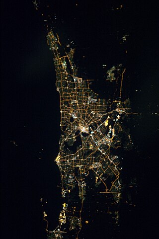
The Perth metropolitan region or the Perth metropolitan area is the administrative area and geographical extent of the Western Australian capital city of Perth and its conurbation.
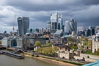
Greater London is the administrative area of London, England, coterminous with the London region. It contains 33 local government districts: the 32 London boroughs, which form a ceremonial county also called Greater London, and the City of London. The Greater London Authority is responsible for strategic local government across the region, and regular local government is the responsibility of the borough councils and the City of London Corporation. Greater London is bordered by the ceremonial counties of Hertfordshire to the north, Essex to the north-east, Kent to the south-east, Surrey to the south, and Berkshire and Buckinghamshire to the west.

The 1955 Plan for the Metropolitan Region, Perth and Fremantle was prepared for the Government of Western Australia by Gordon Stephenson and Alistair Hepburn. The plan was the first regional plan for Perth, and provided the basis for land use zoning under the Metropolitan Region Scheme. Even though not every recommendation of the report was adopted it is considered to have provided the underlying template for the modern development of Perth. The plan was superseded by the Corridor Plan for Perth in 1970.

A greater city movement refers to various reform efforts—both contemporary and historical—to expand the municipal boundaries of a primate central city to incorporate all, or part, of the surrounding metropolitan population. Historically, greater city movements were proposed as a solution to the problem of metropolitan planning and administration. Today, the concept has been largely discredited for political reasons Historically, examples of cities that have successfully expanded their boundaries to include the entire metropolitan population are extremely rare, and as a general principle few, if any cities worldwide have been able to maintain a continuous process of boundary adjustment to include surrounding areas of population growth.
The Melbourme Metropolitan Planning Scheme 1954 was prepared for the Government of Victoria by the Melbourne and Metropolitan Board of Works. The scheme was approved in 1958 by the Board of Works, but did not become legally enforceable until 1968 when it was gazetted by the Minister for Local Government. The report recommended, amongst other things, a system of broad land-use zoning, a network of freeways and bypasses, and the regional allocation of public open space. The scheme identified five district centres of Footscray, Preston, Box Hill, Moorabbin and Dandenong. Local government authorities prepared local planning schemes which were intended to align with the Metropolitan Scheme's broad zones, but which frequently did not.
Directions 2031 is an overarching strategic plan for the Perth metropolitan area published by the Western Australian Planning Commission. It replaced the draft 2004 Network City and was the first strategic plan to be formally adopted since Metroplan in 1991. Detailed sub-regional planning frameworks were published separately as part of Perth and Peel @ 3.5 million. These frameworks, covering Perth’s Central, North-West, North-East and Southern regions, included specific population targets for each local government area to accommodate 800,000 people by 2030.