| Country | Local name | Maximum speed (km/h) | Details | Notes |
|---|
| Australia | Shared Zone | 10 | | |
| Bike boulevard | 30 | Described by the Department of Transport (Western Australia) as "an innovative program designed to make cycling safer and easier". Bike boulevards are marked with blue-and-white Safe Active Street road patches at major entry points. [56] | |
| Austria | Wohnstraße [ de ]
("Living street") | | Similar legislation as in Germany | |
| Belgium | Woonerf , erf [57] (Dutch)
Zone résidentielle, zone de rencontre [58] (French) | 20 | Usually same grade, parking is only allowed in marked places. | |
| Canada | Woonerf | | | Woonerfs are planned for Toronto, [59] where they have been approved for the West Don Lands community and are being discussed for Queens Quay along the waterfront, Honest Ed's redevelopment in Mirvish Village and for Montreal, [60] where one will replace an alley covering the former course of the St-Pierre river in Saint-Henri. |
| Colombia | Calle cívica or calle de encuentro
("Civic street" or "encounter street") | 10–20 [61] | Pedestrians, children and cyclists are encouraged to use the complete space. | |
| Czech Republic | Obytná zóna [ cs ] ("Residential zone") | 20 | Usually same grade, parking is only allowed in marked places. | In Czech law since 2001 |
| Croatia | Zona smirenog prometa [ hr ]
("Traffic calm zone") | 10 | | |
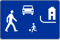
| Finland | Pihakatu
("Yard street") | 20 | Pedestrians have absolute right of way. Parking is only allowed for bicycles and mopeds or in marked places. | The first living street was introduced in 1982 in Forssa. |
| France | Zone de rencontre [ fr ]
("Encounter zone") | 20 | Usually same grade, parking restrictions not specified | The first living street was introduced in 2008. |
| Germany | Verkehrsberuhigter Bereich
("Traffic calming area") | 6 | Vehicles should not travel faster than a pedestrian speed. If not same grade then street usable by pedestrians. Parking is only allowed in marked places. Pedestrians, including children, may use the entire street and children are permitted to play in the street In everyday language, a Verkehrsberuhigter Bereich is also (falsely) called a Spielstraße ("play street"). | Under German traffic law motorists in a Verkehrsberuhigter Bereich are restricted to a maximum speed of 7 km/h. [62] First trials occurred in 1977, incorporated into traffic laws in 1980. |
| Iceland | Vistgata | 15 | Vehicles should not travel faster than 15 km/h and must yield to pedestrians, cyclists and children at play. If a pedestrian is near, the allowed top speed is walking speed. Pedestrians are however not permitted to un-necessarily hinder the travel of the vehicle. Both beginning and end of living streets are marked. | Introduced into law in 1985 |
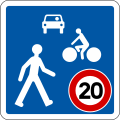
| Italy | Zona residenziale | 30 | Vehicles should not travel faster than 30 km/h without interfering with pedestrians or cyclists. Both beginnings and endings of living streets are marked. | Introduced by the legislation on traffic in 1995. Actually it is seldom fully implemented like in the original Dutch model; very often a "Zona 30" is only indicated by a street sign and the speed limit. |
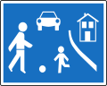
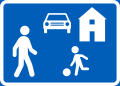
| Ireland | Crios Mall
Slow Zone | 30 | A self-contained grouping of houses with single or multiple entry points for vehicles. Such areas often have green areas or play areas within them. The needs of vulnerable road users are merely "deemed to take precedence over those of motorists". [63] | A "slow zone" differs from a "shared space"; as such, no shared space attributes are necessarily put in place, unlike other countries. Instead, other traffic calming measures are installed, such as speed bumps. |
| Mexico | Vía de tránsito mixto ("Mixed transit road") | 10–20 | Installed only if the street has limited parking areas, is paved with some speed-limiting material or possesses some kind of traffic-calming measures and is designed with a single grade to favor intermingled use. | |
| Netherlands | Woonerf | 15 | Usually same grade | |
| New Zealand | Shared Zone | | Similar to Australia | |
| Norway | Gatetun ("Street yard") | 15 | | |
| Poland | Strefa zamieszkania
("Residential zone") | 20 | Pedestrians (including playing children, even without parental supervision) can use entire street and have absolute precedence over vehicles. Parking is only allowed in marked places. Speed calming devices do not have to be marked using road signs. The sign that marks an end of a living street also obligates a driver to give way to other participants in road traffic [64] | |
| Russia | Жилая зона [ ru ]
("Living zone") | 20 | No through traffic or parking with engine running. | |
| Serbia | Zona usporenog saobraćaja ("Decelerated-traffic zone") | 10 | Vehicles should not travel faster than a pedestrian speed and without interfering with pedestrians or cyclists. Both beginnings and endings of living streets are marked. [65] | Introduced by the legislation change in 2009, with first living streets introduced in September 2010. [66] |
| Slovakia | Obytná zóna [ sk ] ("Residential street") | 20 | Usually same grade, parking is only allowed in marked places. | |
| Spain | Calle residencial ("Residential street") | 20 | Pedestrians (including playing children, even without parental supervision) can use entire street and have full right of way, however, the pedestrian shall not prevent a vehicle passing through. No parking except in marked places. Both beginnings and endings of living streets are marked. | |
| Sweden | Gångfartsområde ("Walking speed area") | 7 | Applies to both motorized vehicles and bikes. Pedestrians have absolute right of way. No parking, except in marked places. | |
| Switzerland | Zone de rencontre
(French: "Encounter zone"), Begegnungszone
(German: "Encounter zone") | 20 | Usually same grade. Parking is only allowed in marked places. | Introduced by the legislation change in September 2001.
Link: Zones de rencontre |
| Turkey | Yaya öncelikli yol ("Pedestrian priority road") | 20 | Pedestrians (including playing children, even without parental supervision) can use entire street and have full right of way, however, the pedestrian shall not prevent a vehicle passing through. No parking except in marked places. Both beginnings and endings of living streets are marked. | |
|
| United Kingdom | Home zone,
Living street | | | Link: Signing |
|


