Bicycle boulevard

Last updated

Bicycle boulevard on Ankeny Street in Portland, Oregon Ankeny neighborhood greenway.JPG
Bicycle boulevard on Ankeny Street in Portland, Oregon

A bicycle boulevard, sometimes referred to as a neighborhood greenway, [1] neighborway, [2] neighborhood bikeway [3] or neighborhood byway [4] is a type of bikeway composed of a low-speed street which has been "optimized" for bicycle traffic. [5] Bicycle boulevards discourage cut-through motor-vehicle traffic but allow local motor-vehicle traffic. They are designed to give priority to bicyclists as through-going traffic. They are intended as a low-cost, politically popular way to create a connected network of streets with good bicyclist comfort and/or safety.

Contents

Bicycle boulevards attempt to achieve several goals:

These bikeway design elements are intended to appeal to casual, risk-averse, inexperienced and younger bicyclists who would not otherwise be willing to cycle with motor vehicle traffic. Compared to a bike path or rail trail, a bicycle boulevard is also a relatively low-cost approach to appealing to a broader cycling demographic.

Features

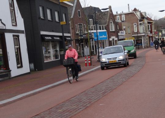
A bicycle boulevard is generally marked with a sign at the beginning and the end of the bicycle boulevard. [6] Also necessary for the road to be called a bicycle boulevard is coloring; in the Netherlands, the parts of the road where the cyclists ride on is marked in red (same color as used for segregated cycle facilities in the Netherlands). These sections of the road are called rabatstroken. [7] Motorists also ride on this section, yet also have a non-colored part of the road which they can drive on with one half (two wheels) of the car when they wish to pass a cyclist. [8]

Bicycle boulevards may use a variety of traffic calming elements to achieve a safe environment. This makes it difficult for motorists to use the street at a high speed. However, they do not block access to motor vehicles completely (i.e. using bollards) which would designate the route as segregated cycle facilities rather than a bicycle boulevard.[ citation needed ]

Some bicycle boulevards have higher road surface standards than other residential streets, and encourage riders to use the full lane, encouraging parity between bicycles and motor vehicles.[ citation needed ]

Discouraging non-local motor vehicle traffic

This diverter forces motor vehicles to turn, and allows through passage for bicyclists and pedestrians. Diverter with bollards.jpg
This diverter forces motor vehicles to turn, and allows through passage for bicyclists and pedestrians.

Permeable barriers such as bollards are sometimes used to allow cycling traffic to continue through while diverting motorized traffic from using the street as a through street.[ citation needed ]

Locations

Road designs of bicycle boulevards can be found in the United States, Canada (Vancouver, Saskatoon, [9] Winnipeg [10] [11] ), the Netherlands, Germany, Belgium, Denmark, France, Spain and New Zealand

United States

Bicycle boulevards can be found in a growing number of United States cities, including: [12]

Palo Alto established the first bicycle boulevard [15] in the United States. It was named for Ellen Fletcher, a Holocaust survivor and one of America's first bike activists. [16]

In Berkeley, boulevards are mostly residential streets, but some sections pass through commercial areas. Generally, there are few cars on these streets, in large part because of the pre-existing traffic calming devices that slow and/or divert traffic. Bicycle boulevards may or may not have bicycle lanes.[ citation needed ]

In Minneapolis, a grant from the federal government within the Non-Motorized Pilot Program helped to build a bike boulevard on Bryant Avenue and the planning of others. [17] [18]

Similarly in Columbia, the Non-Motorized Pilot Program project helped fund the first bike boulevard in Missouri along Ash and Windsor Streets. At least one other was planned.[ citation needed ]

In Wilmington, help from a Fit Community 2009 grant through the North Carolina Health and Wellness Trust Fund enabled the City of Wilmington to construct North Carolina's first bicycle boulevard. The Ann Street Bicycle Boulevard runs from South Water Street to South 15th Street [19] and serves as part of the much longer River to the Sea Bikeway, [20] which connects downtown Wilmington to Wrightsville Beach.[ citation needed ]

In Portland, a $600 million 20-year plan (2010–2030) has the goal of making 25 percent of trips in the city be by bicycle through the establishment of 700 miles (1,100 km) of new bikeways; one of the projects within the plan is to combine the work on street features that reduce stormwater runoff with the construction of curb extensions and other components of bicycle boulevards. [21]

In Albuquerque, a city with more than 400 miles (640 km) of on-street bicycle facilities and multi-use trails, [22] the grand opening of the first bicycle boulevard in New Mexico was held on April 14, 2009. The bicycle boulevard runs from San Mateo Blvd SE, west along Silver Ave SE/SW to 14th St SW. It then continues north on 14th St to Mountain Rd NW. The last leg continues west on Mountain Rd NW to the Paseo del Bosque Recreation Trail which parallels the Rio Grande.[ citation needed ]

In Madison, the first full bicycle boulevard spans East Mifflin Street in Madisons Tenney-Lapham Neighborhood, a second spans the entire length of Kendall Avenue in University Heights and the Regent Neighborhood.[ citation needed ]

In Seattle, the city is implementing a city-wide network of "Neighborhood Greenways". [14] The work is being carried out with the aid and cooperation of the non-profit "Seattle Neighborhood Greenways". [23]

US naming conventions

The City of Berkeley, California, is credited with coining the phrase bicycle boulevard in the late 1980s,[ by whom? ] but not every jurisdiction has adopted this term. In November 2011, the City of Boston began to use the term neighborways instead of bicycle boulevards. This added to a growing list of terms for bicycle boulevards since Portland has been calling them neighborhood greenways; Seattle has followed the same convention. [14]

Other terms for bicycle boulevards in the US include:[ original research? ]

  • Cyclestreets
  • Bike boulevards
  • Quiet streets
  • Neighborhood byways
  • Bicycle-friendly streets
  • Bicycle-friendly corridors
  • Bicycle parkways
  • Neighborhood parkways
  • Bicycle greenways

Netherlands

In the Netherlands, fietsstraten  [ nl ] ('cycle streets') have a similar road design — although most residential streets in the Netherlands which do not have on-road bike lanes or segregated bike lanes would fit the American definition of bicycle boulevards. A fietsstraat can link dedicated bike-only paths, service roads, and other types of bike-friendly street configurations to complete a route. (Extensive information has been compiled about these facilities at the Pedal Portland blog [24] and the Northeastern University webpage.) [25]

In Amsterdam for example, by 2005 about 40% of journeys were by bicycle and transport planners at the Dienst Infrastructuur Verkeer en Vervoer (Infrastructure Traffic and Transport Directorate) have adopted a bicycle policy that blends many different bike-friendly street designs such as segregated bicycle lanes, on-road bicycle lanes and fietsstraten. [26] The general concept is that cyclists can integrate relatively safely with vehicular traffic that is travelling at, or below, 30 km/h (19 mph) but that segregated bike lanes should be installed along roads with a higher speed limit. With these, and many other, bike-friendly policies in place, Amsterdam has the highest rate of cycling of any capital city in the world. Cycle streets are also on the rise in other cities within the country, including Utrecht. [27] [28]

Bicycle boulevard in Barcelona, Spain Fahrradstrasse-barcelona.jpg
Bicycle boulevard in Barcelona, Spain

Germany

In Germany a comparable road design is called Fahrradstraße  [ de ] ('bicycle road'), introduced into the Highway Code in 1997. [29] Any other vehicles are prohibited unless marked with an additional sign. [30]

Belgium

In Belgium, the Fietsstraat  [ nl ] (in Dutch/Flemish) or rue cyclable (in French), was introduced into the Highway Code with effect from 13 February 2012. [31] One had earlier been introduced in the Visserij in Ghent (Gent) in the summer of 2011. The first one in Brussels appeared in 2013 on a service road alongside Avenue Louise.[ citation needed ]

The OpenStreetMap wiki and also the several locations on this subject may be of interest to reader.

Denmark

In Denmark, the first cykelgade was opened in 2011 in Aarhus. [32] Since then cycle streets have been implemented in several cities across the country.

France

In France, the equivalent road design is called vélorue ('bike street') or rue cyclable ('cycle street'). The cities of Strasbourg (2017), Bordeaux (2018) and Dijon (2019) are among the first to test it out.

Spain

In Spain, cycle streets are known as ciclocalles.[ citation needed ]

New Zealand

In New Zealand, bicycle boulevards are generally designated as 'neighbourhood greenways', [33] although Auckland refers to them as local paths [34] to avoid confusion with its off-road greenways network. Christchurch was the first city to implement a number of neighbourhood greenway sections as part of its Major Cycle Routes programme, including the Rapanui–Shag Rock Stage 1 through Linwood. [35]

See also

Related Research Articles

<span class="mw-page-title-main">Bike lane</span> Road traffic lane for cyclists

Bike lanes (US) or cycle lanes (UK) are types of bikeways (cycleways) with lanes on the roadway for cyclists only. In the United Kingdom, an on-road cycle-lane can be firmly restricted to cycles or advisory. In the United States, a designated bicycle lane or class II bikeway (Caltrans) is always marked by a solid white stripe on the pavement and is for 'preferential use' by bicyclists. There is also a class III bicycle route, which has roadside signs suggesting a route for cyclists, and urging sharing the road. A class IV separated bike way (Caltrans) is a bike lane that is physically separate from motor traffic and restricted to bicyclists only.

<span class="mw-page-title-main">John Forester (cyclist)</span> English industrial engineer and bicycle activist (1929–2020)

John Forester was an English-American industrial engineer, specializing in bicycle transportation engineering. A cycling activist, he was known as "the father of vehicular cycling", for creating the Effective Cycling program of bicycle training along with its associated book of the same title, and for coining the phrase "the vehicular cycling principle" – "Cyclists fare best when they act and are treated as drivers of vehicles". His published works also included Bicycle Transportation: A Handbook for Cycling Transportation Engineers.

<span class="mw-page-title-main">Vehicular cycling</span> Practice of riding bicycles on roads while obeying roadway rules

Vehicular cycling is the practice of riding bicycles on roads in a manner that is in accordance with the principles for driving in traffic, and in a way that places responsibility for safety on the individual.

<span class="mw-page-title-main">Non-motorized access on freeways</span>

Non-motorized access on freeways may allow or restrict pedestrians, bicyclists and other non-motorized traffic to use a freeway. Such roads are public ways intended primarily for high-speed travel over long distances, and they have resulted in highways in the United States with engineering features such as long sight-distances, wide marked lanes and the absence of cross traffic. These provide faster and safer travel, at least for vehicles driving at similar speeds.

A wide outside lane (WOL) or wide curb lane (WCL) is an outermost lane of a roadway that is wide enough to be safely shared side by side by a bicycle and a wider motor vehicle at the same time. The terms are used by cyclists and bicycle transportation planners in the United States. Generally, the minimum-width standard for a WOL in the US is 14 feet. A wide outside through lane (WOTL) is a WOL that is intended for use by through traffic.

<span class="mw-page-title-main">Bicycle transportation planning and engineering</span>

Bicycle transportation planning and engineering are the disciplines related to transportation engineering and transportation planning concerning bicycles as a mode of transport and the concomitant study, design and implementation of cycling infrastructure. It includes the study and design of dedicated transport facilities for cyclists as well as mixed-mode environments and how both of these examples can be made to work safely. In jurisdictions such as the United States it is often practiced in conjunction with planning for pedestrians as a part of active transportation planning.

<span class="mw-page-title-main">Cycle track</span> Bikeway between a road and sidewalk, protected by barriers

A cycle track, separated bike lane or protected bike lane is an exclusive bikeway that has elements of a separated path and on-road bike lane. A cycle track is located within or next to the roadway, but is made distinct from both the sidewalk and general purpose roadway by vertical barriers or elevation differences.

<span class="mw-page-title-main">Shared lane marking</span>

A shared lane marking, shared-lane marking, or sharrow is a street marking installed at various locations worldwide, such as New Zealand, Australia, Canada, Spain, and the United States. This marking is placed in the travel lane to indicate where people should preferably cycle.

<span class="mw-page-title-main">Cycling in New York City</span>

Cycling in New York City is associated with mixed cycling conditions that include dense urban proximities, relatively flat terrain, congested roadways with stop-and-go traffic, and streets with heavy pedestrian activity. The city's large cycling population includes utility cyclists, such as delivery and messenger services; cycling clubs for recreational cyclists; and increasingly commuters. Cycling is increasingly popular in New York City; in 2018 there were approximately 510,000 daily bike trips, compared with 170,000 daily bike trips in 2005.

<span class="mw-page-title-main">Cycling in Toronto</span>

Toronto, Ontario, like many North American cities, has slowly been expanding its purpose-built cycling infrastructure. The number of cyclists in Toronto has been increasing progressively, particularly in the city's downtown core. As cycling conditions improve, a cycling culture has grown and alternatives such as automobiles are seen as less attractive. The politics of providing resources for cyclists, particularly dedicated bike lanes, has been contentious, particularly since the 2010s.

Cycling in Illinois encompasses recreation, bikeways, laws and rules, and advocacy. The director of the Illinois Department of Natural Resources, Joel Brunsvold, explained Illinois cycling opportunities: “Bicycle riding is one of the most popular outdoor recreational activities in Illinois, enjoyed by young and old alike...Illinois has a variety of trails for the public to enjoy. The terrain includes flat prairie land to rolling hills, towering bluffs to the breathtaking river and lakefront views.” Many communities across the state are updating bicycle infrastructure in order to accommodate the increased number of cyclists on the roads.

<span class="mw-page-title-main">Cycling in Portland, Oregon</span>

Bicycle use in Portland, Oregon has been growing rapidly, having nearly tripled since 2001; for example, bicycle traffic on four of the Willamette River bridges has increased from 2,855 before 1992 to over 16,000 in 2008, partly due to improved facilities. The Portland Bureau of Transportation says 6% of commuters bike to work in Portland, the highest proportion of any major U.S. city and about 10 times the national average.

<span class="mw-page-title-main">Cycling infrastructure</span> Facilities for use by cyclists

Cycling infrastructure is all infrastructure cyclists are allowed to use. Bikeways include bike paths, bike lanes, cycle tracks, rail trails and, where permitted, sidewalks. Roads used by motorists are also cycling infrastructure, except where cyclists are barred such as many freeways/motorways. It includes amenities such as bike racks for parking, shelters, service centers and specialized traffic signs and signals. The more cycling infrastructure, the more people get about by bicycle.

<span class="mw-page-title-main">Bicycles May Use Full Lane</span>

The Bicycles May Use Full Lane sign, also referred to as BMUFL or R4-11, first officially specified in Chapter 9B of the 2009 Manual on Uniform Traffic Control Devices, is a traffic sign used in the United States to:

The history of cycling infrastructure starts from shortly after the bike boom of the 1880s when the first short stretches of dedicated bicycle infrastructure were built, through to the rise of the automobile from the mid-20th century onwards and the concomitant decline of cycling as a means of transport, to cycling's comeback from the 1970s onwards.

<span class="mw-page-title-main">Protected intersection</span> At-grade road junction in which cyclists and pedestrians are separated from cars

A protected intersection or protected junction, also known as a Dutch-style junction, is a type of at-grade road junction in which cyclists and pedestrians are separated from cars. The primary aim of junction protection is to help pedestrians and cyclists be and feel safer at road junctions.

<span class="mw-page-title-main">Safety of cycling infrastructure</span> Overview of bicycle safety concerns

There is debate over the safety implications of cycling infrastructure. Recent studies generally affirm that segregated cycle tracks have a better safety record between intersections than cycling on major roads in traffic. Furthermore, cycling infrastructure tends to lead to more people cycling. A higher modal share of people cycling is correlated with lower incidences of cyclist fatalities, leading to a "safety in numbers" effect though some contributors caution against this hypothesis. On the contrary, Older studies tended to come to negative conclusions about mid-block cycle track safety.

<span class="mw-page-title-main">Bikeway controversies</span>

Controversies have surrounded dedicated cycling routes in cities. Some critics of bikeways argue that the focus should instead be placed on educating cyclists in road safety, and others that safety is better served by using the road space for parking. There is debate over whether cycle tracks are an effective factor to encourage cycling or whether other factors are at play.

The city of Madrid has been increasing in the last years its network of bicycle paths. In 2016, there were 195 km of cycling routes. The former city council had been planning to build 400 km more for the year 2024 despite a very vocal opposition to the construction of segregated infrastructure by a significant part of the local cycling community. However now with the new right wing mayor elected in 2019 the city is set to be the only capital in the world where bicycle lanes are being removed again.

<span class="mw-page-title-main">Cycling in Halifax, Nova Scotia</span> Cycling infrastructure in Halifax, Nova Scotia

Cycling infrastructure in the Canadian city of Halifax, Nova Scotia includes most regular streets and roads, bike lanes, protected cycle tracks, local street bikeways, and multi-use pathways.

References

  1. "Neighborhood Greenways | The City of Portland, Oregon". Portlandoregon.gov. Retrieved 17 August 2016.
  2. "Louisville Neighborways". LouisvilleKy.gov. 25 September 2014. Retrieved 17 August 2016.
  3. "Neighborhood Bikeway Plan". Co.washington.or.us. 13 May 2015. Retrieved 17 August 2016.
  4. "Transportation - What is a Neighborhood Byway? | Salt Lake City - The Official City Government Website". Slcgov.com. Retrieved 17 August 2016.
  5. "Bicycle Boulevards - National Association of City Transportation Officials". Nacto.org. 20 June 2014. Retrieved 17 August 2016.
  6. "Nieuws | Fietsersbond". Archived from the original on 16 April 2014. Retrieved 15 April 2014.
  7. "Fietsstraat" [Street bike] (in Dutch). Gemeentehuis Oss. 14 April 2011. Archived from the original on 13 August 2016. Retrieved 12 August 2016.
  8. "Image of colored parts of the road and non-colored section" (JPG). Verkeerskunde.nl. Retrieved 17 August 2016.[ non-primary source needed ]
  9. "Bike Boulevard". saskatoon.ca. Archived from the original on 13 June 2013. Retrieved 20 August 2013.
  10. "Powers Bike Boulevard". City of Winnipeg. Archived from the original on 26 August 2013. Retrieved 20 August 2013.
  11. "Eugenie Bike Boulevard" (PDF). City of Winnipeg. Archived from the original (PDF) on 11 December 2013. Retrieved 20 August 2013.
  12. "States are Losing Millions in Biking and Walking Funds". Streets Blog USA. Angie Schmitt. 5 September 2018. Retrieved 17 November 2018.
  13. "Bicycle Boulevards". City of Minneapolis. Archived from the original on 10 August 2011. Retrieved 8 November 2011.
  14. 1 2 3 "Neighborhood Greenways". Seattle Department of Transportation. February 2018. p. 1.
  15. Krieg, Martin. "Founder". National Bicycle Greenway (NBG). Archived from the original on 31 May 2012. Retrieved 25 July 2012.
  16. Szczepanski, Carolyn (18 March 2013). "Women's (Bike) History: Ellen Fletcher". News from the League, March 18, 2013. League of american bicyclists. Retrieved 24 August 2018.
  17. "Minneapolis Sets Out to Build 30 Miles of Protected Bike Lanes By 2020". Streets Blog USA. Angie Schmitt. 21 April 2015. Retrieved 17 November 2018.
  18. "From Minneapolis: Ten Street Design Solutions to Transform Your City". Streets Blog USA. Carolyn Szczepanski. 22 August 2011. Retrieved 17 November 2018.
  19. "River to the Sea Bikeway in Wilmington, NC". Rivertoseabikeway.com. Retrieved 17 August 2016.
  20. "River to the Sea Bikeway in Wilmington, NC". Rivertoseabikeway.com. 7 May 2016. Retrieved 17 August 2016.
  21. James Mayer (6 March 2010). "Mayor Adams finds $20 million for bike boulevards". The Oregonian. Archived from the original on 9 March 2010. Retrieved 8 March 2010.
  22. "Bicycling — City of Albuquerque". Cabq.gov. Archived from the original on 12 October 2012. Retrieved 17 August 2016.
  23. "Seattle Neighborhood Greenways :: Safe Streets for All". Seattle Neighborhood Greenways. Retrieved 3 March 2018.
  24. "The Netherlands' Neighborhood Greenways – Can We Make Portland's Greenways More Like Theirs?". pedalportland.org. Archived from the original on 23 August 2011. Retrieved 27 November 2011.
  25. "Bicycling Facilities in Holland". coe.neu.edu. Archived from the original on 23 September 2011. Retrieved 27 November 2011.
  26. (in Dutch) Dienst Infrastructuur Verkeer en Vervoer Archived 2005-01-27 at the Wayback Machine , official website of the Dutch Traffic and Transport Infrastructure Service
  27. "Dnu". Archived from the original on 16 April 2014. Retrieved 15 April 2014.
  28. "Pagina niet gevonden 404 | Gemeente Utrecht". Archived from the original on 16 April 2014. Retrieved 15 April 2014.
  29. Alrutz, D./ Stellmacher-Hein, J.: Sicherheit des Radverkehrs auf Erschließungsstrassen, Berichte der Bundesanstalt für Straßenwesen, Heft V 37; Bergisch Gladbach 1997, German
  30. OpenStreetMap description of bicycle road
  31. "Fietsstraat krijgt officieel verkeersbord".
  32. Jesper Bech Pedersen (22 June 2011). "Mejlgade bliver Danmarks første cykelgade" [Mejlgade will be Denmark's first bicycle street]. stiften.dk (in Danish).
  33. "Neighbourhood greenways". Waka Kotahi NZ Transport Agency.
  34. "Greenways, Bike Boulevards and Local Paths - Auckland's new Cycleway Guidelines". Bike Auckland. 9 October 2016.
  35. "First Look: Rapanui Cycleway Stage 1 – Cycling in Christchurch". cyclingchristchurch.co.nz. 17 December 2017. Retrieved 24 August 2018.

Further reading