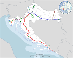
Map of the Croatian motorway network in 2025A6interchange in Orehovica near RijekaDynamics of the development of the Croatian motorway network: the length of the motorway network in Croatia 1993-2009
Highways in Croatia are the main transport network in Croatia. The Croatian classification includes several categories of highways:[1]
Expressways (brza cesta) are toll-free limited-access highways with grade-separated intersections and fast speed limits. They are similar to the motorways, but are not always dual carriageways and may have no emergency lanes. Their speed limit is always lower than that of the motorways. They either have standalone designations or are parts of non-motorway state routes, such as the D prefixed highways described further below.
Roads dedicated for motor vehicles (cesta namijenjena isključivo za promet motornih vozila), which is another category of limited-access highways. They usually have multiple lanes and separated carriageways but may have at-grade intersections. This class of roads has no specific numbering convention, only a dedicated traffic sign. State routes (D roads) or portions thereof may be designated in this manner. An example is Jadranska Avenue in Zagreb, designated as Ž1040, a county road.[2]
Other than the motorway routes, the national road classification includes the following enumerated categories of routes in the national highway system, with decreasing order of priority:[2]
State roads, which are marked by letter D (državna cesta) and a single, double or triple digit number.
County roads always are marked by letter Ž (županijska cesta) and a four digit number.
The lowest classification comprises local roads, marked by letter L (lokalna cesta) and a five digit number.
Road operators differ according to the classification system: The designated motorways are operated by three different concessionaires. The state roads are maintained almost exclusively by Hrvatske ceste, while the county and local roads are managed by various county authorities. The road maintenance agencies are governed by various laws issued by the Parliament as well as bylaws issued by the Ministry of Transport.[1][3]
Motorways
Autoceste are marked with this sign in Croatia
The primary high-speed motorways are called autoceste (Croatian pronunciation:[ˈautot͡sesta] singular: autocesta), and they are defined as roads with at least three lanes in each direction (including hard shoulder) and a speed limit of not less than 80 kilometres per hour (50mph). They are marked with a special road sign, similar to the road sign depicting a motorway/autoroute/autobahn in other parts of Europe.[4] The Croatian motorway (autocesta) network is 1,360.5 kilometres (845.4mi) long.[5]
A major reason for the motorway construction "mania" of the 2000s is a previous political halt of the major Croatian highway project, today's A1, in the 1970s and 1980s under former Yugoslavia. When Croatia declared independence in 1991, the only true motorways in the country were Rijeka–Kikovica (the westernmost part of today's A6), Zagreb–Karlovac (the northernmost part of today's A1) and Zagreb–Slavonski Brod (the central part of today's A3), the latter being part of the Brotherhood and Unity Highway. The dream to connect the two largest Croatian cities Zagreb and Split with a motorway (autocesta) went back to the times of the Croatian Spring, but construction of this project was never realized in the Yugoslav period.
A7 motorway, Croatian motorway network was largely built in the 2000s
In 2005, the Zagreb–Split route was constructed. In addition, the A1 was extended towards Dubrovnik (currently at Ploče), and the A3 was extended so it connects Zagreb to Croatian borders with both Serbia (near Lipovac) and Slovenia (near Bregana). There is also a motorway from Zagreb to Rijeka, the A6, as well as the A4 motorway from Zagreb to the northeast (Hungarian border) as well as the A2 motorway from Zagreb to the northwest (Slovenian border). The A9 between Pula and the Slovenian border is also largely completed.
The construction of additional motorways has noticeably slowed in the 2010s, but it continues. As of 2021[update], the Cerovlje–Rijeka section of A8, the remaining part of the Istrian Y, is being upgraded from semi-highway status.[9] The other motorways are in various early stages of development, coming up to a total of 11 motorway routes. The A1 is considered unfinished as it is planned to be extended from Ploče to Dubrovnik.[10]
Operators
The network is managed by 3 operators, of which one is under full government control and other two are operated by joint ventures.[5]
The A5 starts on the border of Hungary near Beli Manastir and proceeds south bypassing Osijek and Đakovo, meets the A3 motorway at Zoljani interchange and proceeds south to Svilaj border bridge where it connects on Bosnian A1 motorway.[maps 5]
The A7 starts at the border of Slovenia and heads south to Rijeka, passes the city as Rijeka bypass. The Rijeka bypass section comprises an interchange with the A6 motorway and proceeds east terminating near Šmrika where the traffic defaults to the D8 state road.[maps 7]
The A8 spans between Kanfanar and Matulji, i.e. the A9 and A7 motorways. As of September 2024, the Kanfanar–Vranja section is brought to the motorway standards, with new tube of Učka tunnel opened and the rest is a limited access two-lane route.[maps 8]
The A10 starts at Bosnian border, where it connects to A1 motorway in Bosnia and runs to the Ploče interchange, where it connects to A1 motorway.[maps 10]
The A11 starts at Jakuševec interchange and runs south to Sisak interchange. It was connected to A3 in November 2015 and it is opened to Sisak in October 2024.[maps 11]
The construction of tunnels Sveta Tri Kralja and Brezovica so the section is upgraded to four lane motorway was expected to begin in the fall of 2022.[17]
Design started in 2020[19] and competition for construction begun in January 2024.[20] Construction will begin in mid-2026.[21]
6.5km (4.0mi)
Novi Vinodolski bypass
Design started in 2023 and competition for construction will start on the end 2026 completing remaining two lanes that will match the right lane of the motorway.[21]
A conceptual design has been developed and the coordination of spatial plans is underway. In parallel, an Environmental Impact Study is being prepared and field research is ongoing.[21]
The preparation of project documentation up to the location permit has been contracted, a conceptual design has been developed, and the Environmental Impact Study is being prepared, and field research is underway.[21]
Traffic cost revenue
In 2022, the network had a traffic of 80,172,262 vehicles, including 70,344,584 light vehicles and 9,827,678 heavy vehicles (difference by axle height).[5]
The travel cost is 9.00 euros per 100 km for light vehicles in closed system and 6.00 euros in open toll system, while for heavy ones are 39.00 euros per 100 km in closed system and 21.00 in open system.[5]
Those costs generate a revenue of 426.5 millions of euros (without VAT) in 2022.[5]
Accidents
Two third of motorway fatalities (67%) occurred in the third of the year between July and October.[22][23]
Motorways fatalities rate per population. View chart definition.
Expressways
Roads designated exclusively for motor vehicles are marked with this sign in Croatia
There is a wide variety of types of expressways in Croatia, in terms of number of lanes, accessibility and types of intersections comprised. They range from four lane expressways with grade-separated intersections and limited access - distinguished from the motorways by lack of emergency lanes only - to four or six lane urban expressways with numerous at-grade intersections and traffic lights or two lane limited access roads with grade separated intersections. The expressways include both incomplete motorways, built in stages,[8] and some state roads (with either limited access, more than two traffic lanes, grade-separated intersections or any combination thereof). There are even some instances of county roads which may be regarded expressways such as Jadranska Avenue (Ž1040).
As a rule, the expressways are not tolled; however, major tunnels on the expressways are tolled.
Karamatići toll station (A1) - Ploče (Čeveljuša interchange) (four lane dual carriageway/two lane single carriageway, with grade separated intersections)
State roads are defined by legislation[2] as important routes for road traffic between various parts of the country. Classification of a road as a state road does not describe actual conditions of the road itself.
State roads in Croatia are assigned one, two or three digit numbers which generally comply with the following pattern[33] (although there are some exceptions to the rules):
1-9 are assigned to trunk roads, normally of considerable length, spanning between borders of various neighboring countries. An obvious exception to this is the D9 state road; however, it spans from Bosnia and Herzegovina border and the Adriatic Sea, along the southernmost portion of Pan-European Corridor Vc.
10-99 are assigned to arterial roads on the mainland.
100s are assigned to island roads
200s are assigned to border crossing access roads.
300s are assigned to junction roads, connecting towns or cities (but not other state roads) to motorways or other major roads. Notable exceptions to this are D307 and D310 state roads, although the D307 originally did not connect to the D29, but only to the A2 motorway.
400s are assigned to mainland port and airport access roads.
500s are assigned to connecting roads, connecting two different state roads. Notable exceptions to this rule are the D503 which connects to a port and the D516 which connects to a border crossing checkpoint.
600s are provisional designations. For example, the road containing Pelješac bridge, from Komarna (D8) to Ston (D416), was designated as D674.[34]
At the moment the state roads in Croatia have a combined length of 6,867.7 kilometres (4,267.4mi).
In the Republic of Croatia, primarily a closed toll system is applied to the entire motorway network tolls with multiple entrances and exits. The use of motorways is charged by mileage and vehicle category. At the entrance on the motorway, the user picks up the entrance card (or a record recorded on the ENC device) and the payment is made on exit toll stations according to the length of the trip. The open system is in use at toll stations Bregana(A3) and Rupa(A7).[5]
Safety
Croatia had 70 road deaths per million inhabitants estimated in 2022.[5]
This page is based on this Wikipedia article Text is available under the CC BY-SA 4.0 license; additional terms may apply. Images, videos and audio are available under their respective licenses.