Zagvozd

Last updated
Zagvozd
Village
Zagvozd 01.jpg
Zagvozd in 2009.
Croatia location map.svg
Red pog.svg
Zagvozd
Coordinates: 43°30′00″N16°57′00″E / 43.500°N 16.950°E / 43.500; 16.950
Country Flag of Croatia.svg Croatia
Historical region Dalmatian Hinterland
County Flag of Split-Dalmatia County.svg  Split-Dalmatia
Municipality Zagvozd
Area
[1]
  Village138.8 km2 (53.6 sq mi)
  Urban
45.1 km2 (17.4 sq mi)
Population
 (2021) [2]
  Village957
  Density6.9/km2 (18/sq mi)
   Urban
640
  Urban density14/km2 (37/sq mi)
Website zagvozd.hr

Zagvozd is a village and a seat of Zagvozd municipality in the Split-Dalmatia County, Croatia. In 2011 it had a population of 767. [3]

Contents

Municipality

Location of the Zagvozd Municipality within Split-Dalmatia County. Zagvozd Municipality.PNG
Location of the Zagvozd Municipality within Split-Dalmatia County.

Zagvozd is a seat of the municipality of the same name. It includes the villages of: Biokovsko Selo, Krstatice, Rastovac, Rašćane Gornje, Župa, Župa Srednja and Zagvozd. In 2011, the municipality had a population of 1,642 (2001 census), 99% of which are ethnic Croats. [3]

History

From 1941 to 1945, Zagvozd was part of the Independent State of Croatia. In the settlements of Zagvozd and Rastovac, at least 190 lost their lives over the course of the war. [4]

Zagvozd was the site of a 1945 torture and massacre of 18 friars and civilians, committed by Yugoslav Partisans. [5] Their remains were discovered in 2005. [5] DNA analysis in Split revealed the identities of three of the victims as Franciscan friars from the town of Široki Brijeg. [6] In 2007, the 15 unidentified bodies were buried in Zagvozd while the identified friars were buried in their native Široki Brijeg. [5]

Culture

Zagvozd celebrates its municipal day on July 16 to coincide with the local celebration of the feast of Our Lady of Mount Carmel. [7]

Related Research Articles

<span class="mw-page-title-main">Donji Lapac</span> Municipality in Lika-Senj, Croatia

Donji Lapac is a settlement and a municipality in Lika, Croatia.

<span class="mw-page-title-main">Petlovac</span> Municipality in Osijek-Baranja, Croatia

Petlovac is a village and municipality in the western part of Baranja, which comprise the northern part of Osijek-Baranja County in Croatia. Petlovac is underdeveloped municipality which is statistically classified as the First Category Area of Special State Concern by the Government of Croatia.

<span class="mw-page-title-main">Srb</span> Village in Croatia

Srb is a village located in the southeastern part of Lika, in Croatia, till 2011 administratively divided into Donji Srb and Gornji Srb. Srb lies in the Una River valley, on the road from Donji Lapac to Knin, and is east of Gračac. It is currently part of the Gračac municipality and the Zadar County.

<span class="mw-page-title-main">Kula Norinska</span> Municipality of Croatia

Kula Norinska is a village and a municipality in the Dubrovnik-Neretva County in southeastern Croatia.

<span class="mw-page-title-main">Desne</span> Village in Dubrovnik-Neretva, Croatia

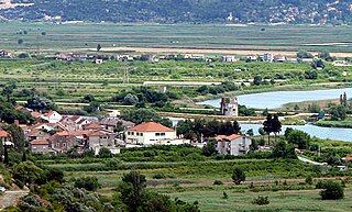
Desne is one of nine villages of the Municipality of Kula Norinska, in the Dubrovnik-Neretva County, on Croatia's Dalmatian coast.

Novo Nevesinje is a settlement in the region of Baranja, Croatia. Administratively, it is located in the Petlovac municipality within the Osijek-Baranja County. Population is 63 people.

Knešpolje is a settlement within the municipality of Široki Brijeg, Bosnia and Herzegovina. In 1991, the settlement had a population of 1,110. It is located along the Mostar-Široki Brijeg roadway.

Brotnja is a village in Croatia. It is connected by the D218 highway.

Boričevac is a village in Croatia.

Zaklopac is a village in Croatia.

Cerovac is a village in Croatia.

Kijani is a village in the Gračac municipality in Croatia.

Omsica is a village in Croatia.

Krstatice

is a village in the Split-Dalmatia County, Croatia located in the Zagvozd municipality. In 2011 it was populated by 123 inhabitants.

Rašćane Gornje is a village in the Split-Dalmatia County, Croatia located in the Zagvozd municipality. In 2011 it was populated by 19 inhabitants.

Rastovac is a village in the Split-Dalmatia County, Croatia located in the Zagvozd municipality. In 2011 it was populated by 168 inhabitants.

Župa is a village in the Split-Dalmatia County, Croatia located in the Zagvozd municipality. In 2011 it was populated by 53 inhabitants.

Župa Srednja is a village in the Split-Dalmatia County, Croatia located in the Zagvozd municipality. In 2011 it was populated by 3 inhabitants.

<span class="mw-page-title-main">Borovci, Kula Norinska</span> Village in Dubrovnik-Neretva County, Croatia

Borovci is a village near Metković in the Kula Norinska municipality with a population of 29.

<span class="mw-page-title-main">Krvavac</span> Village in Dubrovnik–Neretva, Croatia

Krvavac is a village in the Kula Norinska municipality.

References

  1. Register of spatial units of the State Geodetic Administration of the Republic of Croatia. Wikidata   Q119585703.
  2. "Population by Age and Sex, by Settlements, 2021 Census". Census of Population, Households and Dwellings in 2021. Zagreb: Croatian Bureau of Statistics. 2022.
  3. 1 2 "Državni zavod za statistiku Republike Hrvatske" (in Serbo-Croatian). Državni zavod za statistiku Republike Hrvatske. Retrieved 2020-03-15.
  4. "Žrtve u Drugom svjetskom ratu i poraću na području Zagvozda i Rastovca". Archived from the original on 2008-10-04. Retrieved 2008-11-08.
  5. 1 2 3 "Zagvozd: Pokopana tijela franjevaca pobijenih 1945. godine" [Zagvozd: Franciscans killed in 1945 were buried]. Jutarnji list (in Croatian). 7 October 2007. Archived from the original on 5 August 2017. Retrieved 12 April 2022.
  6. Skeletal Remains from World War II Mass Grave: from Discovery to Identification, Croatian Medical Journal
  7. "Zagvozd Day". Archived from the original on 2011-07-21. Retrieved 2008-09-04.