Cerovlje

Last updated
Cerovlje
Cerreto d'Istria
Cerovlje Municipality
Općina Cerovlje
Cerovlje map.png
Location of the municipality in Istria
Croatia location map.svg
Red pog.svg
Cerovlje
Coordinates: 45°16′41″N14°0′36″E / 45.27806°N 14.01000°E / 45.27806; 14.01000
Country Flag of Croatia.svg  Croatia
County Zastava Istarske zupanije.svg Istria
Area
[1]
   Municipality 105.6 km2 (40.8 sq mi)
  Urban
5.3 km2 (2.0 sq mi)
Population
 (2021) [2]
   Municipality 1,453
  Density14/km2 (36/sq mi)
   Urban
197
  Urban density37/km2 (96/sq mi)
Time zone UTC+1 (CET)
  Summer (DST) UTC+2 (CEST)
Postal code
52402
Area code 52
Website cerovlje.hr

Cerovlje (Italian : Cerreto) is a village and a municipality in Istria, Croatia.

Contents

Description

Many ancient towns and decayed castles (Belaj, Posert, Paz, Gologorica, Gradinje) can be found in its territory. Almost every town or castle in Cerovlje is on top of a hill, from where they could see enemies from a farther distance. During the Middle Ages (under the reign of the Holy Roman Empire), the people of Cerovlje also built many churches.

Demographics

According to the 2021 census, its population was 1,453 with 197 living in the village proper. [2]

The total population of Cerovlje-Cerreto was 1,667 in 2011. [3]

The census of 2011 had recorded the following settlements: [3]

Municipal population

Population number according to the census [4]
18571869188018901900191019211931194819531961197119811991200120112021
3.5853.7073.9543.9934.1854.3784.4054.7803.8343.6073.0492.4852.0241.8151.7451.6771.453

Note: Emerged from old Pazin municipality. From 1857 until 1971 includes part of the data of Pazin.

See also

Related Research Articles

<span class="mw-page-title-main">Otok, Vukovar-Syrmia County</span> Town in Slavonia, Croatia

Otok is a town in eastern Croatia, located 20 km south of Vinkovci, in eastern Slavonia. The settlement gained the status of town by the decision of the Parliament of Croatia on July 13, 2006. At the time, nearby Privlaka was a part of the municipality, but was subsequently declared a municipality in its own right. The population of the town of Otok is 6,343, with 4,694 residents in Otok itself and 1,649 in the nearby village of Komletinci. In the census of 2011, 99.31% of the population declared themselves Croats.

<span class="mw-page-title-main">Sveta Nedelja, Istria</span> Municipality in Istria County, Croatia

Sveta Nedelja is a municipality of twenty villages in Croatia. The three largest villages are municipal seat Nedešćina (604), Štrmac (439) and Šumber. Sveta Nedelja is located on a high plateau above the Raša river valley and in the hinterland of the town of Labin.

<span class="mw-page-title-main">Žminj</span> Municipality in Istria County, Croatia

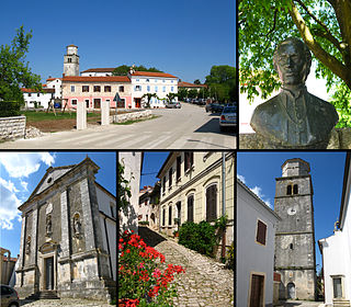
Žminj is a municipality and small town in Istria, Croatia, 15 km south of Pazin.

<span class="mw-page-title-main">Karojba</span> Municipality in Istria County, Croatia

Karojba is a village and municipality in Istria, Croatia located 18 km north-west of Pazin.

<span class="mw-page-title-main">Kršan</span> Municipality in Istria County, Croatia

Kršan is a village and municipality in the eastern part of Istria County, Croatia.

<span class="mw-page-title-main">Lanišće</span> Municipality in Istria County, Croatia

Lanišće is a village and municipality in the mountainous Ćićarija area, Istria, Croatia. In 2011, the population of the village itself is 88, with a total of 329 residents in the municipality. Over 92.40% of the population are Croats. There are fourteen settlements in the municipality: Brest, Brgudac, Dane, Jelovice, Klenovšćak, Kropinjak, Lanišće, Podgaće, Prapoće, Račja Vas, Rašpor, Slum, Trstenik and Vodice.

<span class="mw-page-title-main">Lupoglav, Istria County</span> Municipality in Istria County, Croatia

Lupoglav is a village and municipality in Istria, Croatia.

<span class="mw-page-title-main">Oprtalj</span> Municipality in Istria County, Croatia

Oprtalj is a village and municipality in Istria, Croatia. Oprtalj is a community in the central northern part of Istria County, situated across the Mirna river valley from the village of Motovun, about 20 km northwest of Pazin.

<span class="mw-page-title-main">Pićan</span> Municipality in Istria County, Croatia

Pićan is a village and municipality in the central part of Istria, Croatia, 12 km southeast of Pazin; elevation 360 m. The chief occupations are agriculture and livestock breeding. It is situated on the D64 state road (Pazin-Kršan-Vozilići). There is a railway station on the former Lupoglav – Raša railway.

<span class="mw-page-title-main">Svetvinčenat</span> Municipality in Istria County, Croatia

Svetvinčenat is a village and municipality in the south of the central part of Istria, Croatia, about 25 km southwest of Pazin and 25 km northeast of Pula.

<span class="mw-page-title-main">Sveti Petar u Šumi</span> Municipality in Istria County, Croatia

Sveti Petar u Šumi is a village and municipality (općina) in Istria County, Croatia.

<span class="mw-page-title-main">Tinjan</span> Municipality in Istria County, Croatia

Tinjan is a village and municipality in Istria, Croatia.

Ježenj is a small village near the town of Pazin in Istria County, Croatia.

Belaj is a small village and Baroque Castle in Istria County, Croatia, in the municipality of Cerovlje. Castle Belaj is a registered Historical Heritage. Castle Belaj historically has numerous hectares of vineyard. In 2017 Belaj Castle opens to the public. In 2011, the population of the village is 16. In the vicinity of the village is another castle Posert.

Polje Čepić or Čepić, is a village in Istria County, Croatia, in the municipality of Kršan.

<span class="mw-page-title-main">Paz, Croatia</span> Place in Istria, Croatia

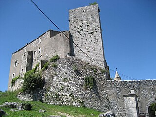
Paz is a village and ruined castle in Istria County, Croatia, in the municipality of Cerovlje. In 2011, the population of the village is 72.

<span class="mw-page-title-main">Gradinje, Cerovlje</span> Village in Istria, Croatia

Gradinje is a village in the Istria County, Croatia. Administratively it belongs to the municipality of Cerovlje. Until recently, the village was inhabited by Istro-Romanians who could speak the Istro-Romanian language.

<span class="mw-page-title-main">Gologorica</span> Village in Istria, Croatia

Gologorica, historically known as Moncalvo di Pisino, is a village in central Istria, near Pazin (Pisino).

Gologorički Dol is a village in Istria, Croatia.

References

  1. Register of spatial units of the State Geodetic Administration of the Republic of Croatia. Wikidata   Q119585703.
  2. 1 2 "Population by Age and Sex, by Settlements" (xlsx). Census of Population, Households and Dwellings in 2021. Zagreb: Croatian Bureau of Statistics. 2022.
  3. 1 2 "Population by Age and Sex, by Settlements, 2011 Census: Cerovlje". Census of Population, Households and Dwellings 2011. Zagreb: Croatian Bureau of Statistics. December 2012.
  4. "Naselja i stanovništvo Republike Hrvatske 1857.-2001" (in Croatian). Retrieved 23 December 2014.