Lupoglav, Istria County

Last updated
Lupoglav
Lupogliano
Municipality
Lupoglav.2.jpg
Main arterial road in Lupoglav
Lupogliano cartina.svg
Location of Lupoglav municipality in Istria
Croatia location map.svg
Red pog.svg
Lupoglav
Coordinates: 45°21′47″N14°06′14″E / 45.36306°N 14.10389°E / 45.36306; 14.10389
Country Flag of Croatia.svg  Croatia
County Zastava Istarske zupanije.svg  Istria County
Area
[1]
  Municipality35.4 sq mi (91.6 km2)
  Urban
3.6 sq mi (9.4 km2)
Population
 (2021) [2]
  Municipality836
  Density24/sq mi (9.1/km2)
   Urban
298
  Urban density82/sq mi (32/km2)
Time zone UTC+1 (CET)
  Summer (DST) UTC+2 (CEST)
Area code 052
Website lupoglav.hr

Lupoglav (Italian : Lupogliano) is a village and municipality in Istria, Croatia.

Contents

The Lupoglav Municipality is situated on the northeast of the Istrian Region. To the east it borders with the Primorsko-Goranska County and with the Istrian municipalities of Lanišće and Cerovlje and the City of Buzet. The municipality is crossed by the arterial roads that connect the Istrian region with the rest of Croatia – the Istrian Y and the tunnel of Učka. The municipality has a surface area of 92.19 km2, i.e. it accounts for 3.27% of the territory of the Istrian Region.

The Castle Mahrenfels which belonged to the family Herberstein and later to the counts Brigido is situated over the village.

Demographics

According to the 2021 census, its population was 836, with 298 living in the village proper. [2] The village population was 288 in 2011, with a total of 924 in the municipality (2011). [3]

The settlements in the municipality are as follows: [3]

Related Research Articles

<span class="mw-page-title-main">Buje</span> Town in Istria, Croatia

Buje is a town situated in Istria, Croatia's westernmost peninsula.

<span class="mw-page-title-main">Medulin</span> Municipality in Istria County, Croatia

Medulin is a municipality in the southern part of the Istrian peninsula in Croatia. Medulin is commonly called the Peak or of Istria.

<span class="mw-page-title-main">Lovran</span> Municipality in Primorje-Gorski Kotar County, Croatia

Lovran is a village and a municipality in Primorje-Gorski Kotar County, Croatia. It is situated in eastern Istria, on the western coast of the Kvarner Bay. Its name derives from Laurel, as shown in the coat of arms.

<span class="mw-page-title-main">Novigrad, Istria County</span> Town in Istria County, Croatia

Novigrad is a town in Istria County in western Croatia. It is also sometimes referred to as Novigrad Istarski to distinguish it from three other Croatian towns of the same name.

Jesenovik is a small village in Istria, Croatia, in the municipality of Kršan. The village is inhabited mostly by Istro-Romanians.

<span class="mw-page-title-main">Kanfanar</span> Municipality in Istria County, Croatia

Kanfanar is a municipality in Istria, Croatia.

<span class="mw-page-title-main">Pićan</span> Municipality in Istria County, Croatia

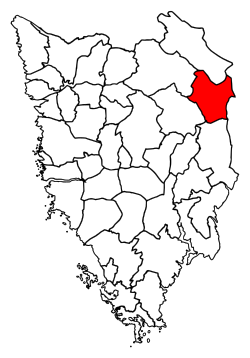
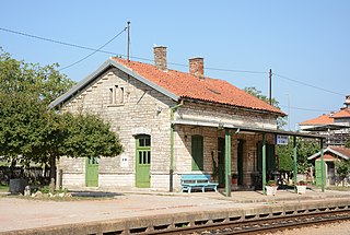
Pićan is a village and municipality in the central part of Istria, Croatia, 12 km southeast of Pazin; elevation 360 m. The chief occupations are agriculture and livestock breeding. It is situated on the D64 state road (Pazin-Kršan-Vozilići). There is a railway station on the former Lupoglav – Raša railway.

<span class="mw-page-title-main">Sveti Petar u Šumi</span> Municipality in Istria County, Croatia

Sveti Petar u Šumi is a village and municipality (općina) in Istria County, Croatia.

<span class="mw-page-title-main">Brckovljani</span> Municipality in Croatia

Brckovljani is a village and a municipality in Zagreb County, Croatia.
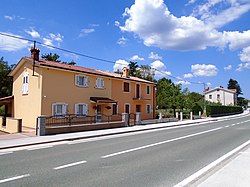
Marceljani s a village in the Labin-Albona municipality in Istria County, Croatia.

<span class="mw-page-title-main">Kožljak</span> Village in Istria County, Croatia

Kožljak is a village in Istria County, Croatia, in the municipality of Kršan. The settlement besides of the village consists of nearby homonymous medieval ruinous castle.

<span class="mw-page-title-main">Šumber</span> Village in Istria County, Croatia

Šumber is a village and ruinous castle in the eastern part of Istria County, Croatia, in the municipality of Sveta Nedelja.

<span class="mw-page-title-main">Dolenja Vas, Lupoglav</span> Village in Istria, Croatia

Dolenja Vas is a village in the municipality of Lupoglav, in Istria County, Croatia.

<span class="mw-page-title-main">Boljun</span> Village in Istria, Croatia

Boljun is a village in the municipality of Lupoglav, in Istria County, Croatia.

<span class="mw-page-title-main">Vranja</span> Village in Istria, Croatia

Vranja is a village in the municipality of Lupoglav, in Istria County, Croatia.

<span class="mw-page-title-main">Boljunsko Polje</span> Village in Istria, Croatia

Boljunsko Polje is a village in the municipality of Lupoglav, in Istria County, Croatia.

Semić is a village in the municipality of Lupoglav, in Istria County, Croatia.

Brest pod Učkom is a village in the municipality of Lupoglav, in Istria County, Croatia.

Lesišćina is a village in the municipality of Lupoglav, in Istria County, Croatia.

Lupoglav is a village in central Croatia, located between Brckovljani and Kloštar Ivanić. The population is 1,086.

References

  1. Register of spatial units of the State Geodetic Administration of the Republic of Croatia. Wikidata   Q119585703.
  2. 1 2 "Population by Age and Sex, by Settlements" (xlsx). Census of Population, Households and Dwellings in 2021. Zagreb: Croatian Bureau of Statistics. 2022.
  3. 1 2 "Population by Age and Sex, by Settlements, 2011 Census: Lupoglav". Census of Population, Households and Dwellings 2011. Zagreb: Croatian Bureau of Statistics. December 2012.