Brtonigla

Last updated
Brtonigla
Vertenejo
Verteneglio
Municipality
Brtonigla Municipality
Općina Brtonigla - Comune di Verteneglio [1]
Chiesaverteneglio.jpg
Church in Brtonigla/Verteneglio/Vertenejo
Brtonigla map.png
Location of Brtonigla municipality in Istria
Croatia location map.svg
Red pog.svg
Brtonigla
Coordinates: 45°23′N13°38′E / 45.383°N 13.633°E / 45.383; 13.633
Country Flag of Croatia.svg  Croatia
County Zastava Istarske zupanije.svg Istria
Government
  MayorPaolo Klaric
Area
[2]
  Municipality32.9 km2 (12.7 sq mi)
  Urban
12.6 km2 (4.9 sq mi)
Elevation
141 m (463 ft)
Population
 (2021) [3]
  Municipality1,523
  Density46/km2 (120/sq mi)
   Urban
705
  Urban density56/km2 (140/sq mi)
Time zone UTC+1 (CET)
  Summer (DST) UTC+2 (CEST)
Website brtonigla-verteneglio.hr

Brtonigla ([ needs Croatian IPA ] Italian : Verteneglio; Venetian : Vertenejo) is a village and a municipality in the north-western part of Istria County, Croatia. Brtonigla is officially bilingual, with Croatian and Italian being equal; in 2011, 40% of the population declared themselves as ethnic Italians. [4]

Contents

Physical geography

View of Brtonigla Bertonigla1.jpg
View of Brtonigla

Brtonigla/Verteneglio was formerly part of the municipality of Buje, which is immediately north, and is bordered to the south by the River Quieto. The old town of Brtonigla originally was placed on top of a hill, but over time it extended to its sides, occupying the entire hill. The area is suitable for agriculture. Wine, grain, corn, oil and vegetables are produced there. It is about 3 km (1.9 mi) from Buje, while it is about 4 km (2.5 mi) from the sea. The nearest seaside resort is Karigador. The summers are long and dry, while the winters are mild and pleasing.

History

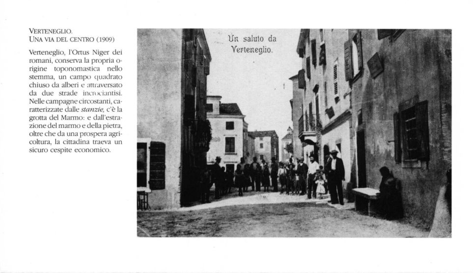
Brtonigla was mentioned for the first time in 1234, with the ancient name Ortoneglo or Hortus Niger, i.e. black ground garden. [5]

In the 11th century Venetians settled in the area, and in the 16th and 17th century Dalmatian and Balkan peasant families settled there too. Vertenejo was part of the Serenissima Republic of Venice and then of the Austro-Hungarian Empire, with the brief parenthesis of the Napoleonic Kingdom of Italy. After the First World War and then the Treaty of Rapallo, the village became part of Italy, a period in which Verteneglio knew its maximum demographic and economic development. After the Second World War it was included in Zone B of the Free Territory of Trieste. With the cession of Zone B to Yugoslavia, most of the Italian population abandoned the village, by then known as Brtonigla. Since 1991, Brtonigla is a municipality in the Istria County of the Republic of Croatia.

Italian-period coat of arms (1920-1947) VerteneglioItaliastemma.jpg
Italian-period coat of arms (1920-1947)

Coat of arms

The municipal symbol became official for the first time during the period of Italian sovereignty (1920-1945). The symbol then consisted of an oval frame enclosing a green field crossed by two dark red streets crossing the center of the coat of arms and the sea (towards the lower part of the coat of arms). [6] The coat of arms that is used since the independence of Croatia perfectly copies the old coat of arms except the sea that has been moved upward. Everything is enclosed in a white frame.

Monuments

Society

Bilingual signes in Brtonigla (Ulica - Via Giuseppe Garibaldi) GiuseppeGaribaldi-Verteneglio.jpg
Bilingual signes in Brtonigla (Ulica - Via Giuseppe Garibaldi)

Languages and dialects

The municipality is bilingual; Brtonigla/Verteneglio is in fact the second Istrian municipality, after Grožnjan/Grisignana, in terms of percentage of Italian-speaking inhabitants. Until before the exodus, the population of Italian ethnicity was between 98 and 100% of the total.

In 2001, Brtonigla/Verteneglio hosted 52.82% Croatian-speakers, 41.29% Italian-speakers, 2.47% Slovenian-speakers and 1.52% Albanian-speakers [8]

In 2011, Brtonigla/Verteneglio hosted 54% Croatian-speakers, 39.79% Italian-speakers, 2.28% Slovenian-speakers and 0.43% Albanian-speakers [9]

Demographics

According to the 2021 census, its population was 1,523, with 705 living in the town proper. [3]

According to the 2011 census, municipality of Brtonigla/Verteneglio had 1,626 residents. [4]

Historical population
of the settlement of Brtonigla/Verteneglio
YearPop.±%
1857 1,139    
1869 1,206+5.9%
1880 1,072−11.1%
1890 1,098+2.4%
1900 1,358+23.7%
1910 1,550+14.1%
1921 2,108+36.0%
1931 2,386+13.2%
1948 1,537−35.6%
1953 989−35.7%
1961 1,107+11.9%
1971 823−25.7%
1981 803−2.4%
1991 736−8.3%
2001 827+12.4%
2011 805−2.7%
Source: Naselja i stanovništvo Republike Hrvatske 1857–2011, DZS, Zagreb

Religions

Religions in Brtonigla
Catholics
85%
Atheists
4%
Muslims
3%
Agnostics
4%
Orthodox
2%

Settlements

Karigador (Carigador) Karigador, Croatia - panoramio (1).jpg
Karigador (Carigador)
Istrian sheep grazing near Brtonigla Ovca u naselju Radini, Istra (Croatia).JPG
Istrian sheep grazing near Brtonigla

The municipality includes several settlements:

Notable residents

Twin towns

Brtonigla/Verteneglio is twinned with:

See also

Related Research Articles

<span class="mw-page-title-main">Istria</span> Peninsula on the Adriatic Sea

Istria is the largest peninsula within the Adriatic Sea. The peninsula is located at the head of the Adriatic between the Gulf of Trieste and the Kvarner Gulf. It is shared by three countries: Croatia, Slovenia, and Italy, with 90% of surface area being part of Croatia. Croatia encapsulates most of the Istrian peninsula within Istria County.

<span class="mw-page-title-main">Free Territory of Trieste</span> Former country in Europe between Italy and Yugoslavia

The Free Territory of Trieste was an independent territory in Southern Europe between northern Italy and Yugoslavia, facing the north part of the Adriatic Sea, under direct responsibility of the United Nations Security Council in the aftermath of World War II. For a period of seven years, it acted as a free city.

<span class="mw-page-title-main">Poreč</span> City in Istria County, Croatia

Poreč is a town and municipality on the western coast of the Istrian peninsula, in Istria County, west Croatia. Its major landmark is the 6th-century Euphrasian Basilica, which was designated a UNESCO World Heritage Site in 1997.

<span class="mw-page-title-main">Istria County</span> County in western Croatia

Istria County is the westernmost county of Croatia which includes the majority of the Istrian peninsula.

<span class="mw-page-title-main">Pula</span> City in Istria County, Croatia

Pula, also known as Pola, is the largest city in Istria County, Croatia, and the seventh-largest city in the country, situated at the southern tip of the Istrian peninsula in northwestern Croatia, with a population of 52,220 in 2021. It is known for its multitude of ancient Roman buildings, the most famous of which is the Pula Arena, one of the best preserved Roman amphitheaters. The city has a long tradition of wine making, fishing, shipbuilding, and tourism. It was the administrative centre of Istria from ancient Roman times until superseded by Pazin in 1991.

<span class="mw-page-title-main">Rovinj</span> City in Istria County, Croatia

Rovinj is a city in Croatia situated on the north Adriatic Sea with a population of 14,294 (2011). Located on the western coast of the Istrian peninsula, it is a popular tourist resort and an active fishing port. Istriot, a Romance language once widely spoken in this part of Istria, is still spoken by some of the residents. The town is officially bilingual, Croatian and Italian, hence both town names are official and equal.

<span class="mw-page-title-main">Umag</span> Town in Istria County, Croatia

Umag is a coastal town in Istria, Croatia.

<span class="mw-page-title-main">Buje</span> Town in Istria, Croatia

Buje is a town situated in Istria, Croatia's westernmost peninsula.

<span class="mw-page-title-main">Julian March</span> Historical region in Croatia, Italy, and Slovenia

The Julian March, also called Julian Venetia, is an area of southern Central Europe which is currently divided among Croatia, Italy, and Slovenia. The term was coined in 1863 by the Italian linguist Graziadio Isaia Ascoli, a native of the area, to demonstrate that the Austrian Littoral, Veneto, Friuli, and Trentino shared a common Italian linguistic identity. Ascoli emphasized the Augustan partition of Roman Italy at the beginning of the Empire, when Venetia et Histria was Regio X.

<span class="mw-page-title-main">Motovun</span> Municipality in Istria County, Croatia

Motovun is a village and a municipality in central Istria, Croatia. In ancient times, both Celts and Illyrians built their fortresses at the location of present-day Motovun. The name of the village is also of Celtic origin, derived from Montona, meaning "a town in the hills". The Parenzana, a narrow-gauge railroad that ran from Trieste to Poreč between 1902 and 1935, passed below the town.

<span class="mw-page-title-main">Novigrad, Istria County</span> Town in Istria County, Croatia

Novigrad is a town in Istria County in western Croatia. It is also sometimes referred to as Novigrad Istarski to distinguish it from three other Croatian towns of the same name.

<span class="mw-page-title-main">Istrian–Dalmatian exodus</span> Post-World War II exodus of ethnic Italians from Yugoslavia

The Istrian–Dalmatian exodus was the post-World War II exodus and departure of local ethnic Italians as well as ethnic Slovenes and Croats from Yugoslavia. The emigrants, who had lived in the now Yugoslav territories of the Julian March, Kvarner and Dalmatia, largely went to Italy, but some joined the Italian diaspora in the Americas, Australia and South Africa. These regions were ethnically mixed, with long-established historic Croatian, Italian, and Slovene communities. After World War I, the Kingdom of Italy annexed Istria, Kvarner, the Julian March and parts of Dalmatia including the city of Zadar. At the end of World War II, under the Allies' Treaty of Peace with Italy, the former Italian territories in Istria, Kvarner, the Julian March and Dalmatia were assigned to now Communist-helmed Federal Yugoslavia, except for the Province of Trieste. The former territories absorbed into Yugoslavia are part of present-day Croatia and Slovenia.

<span class="mw-page-title-main">Grožnjan</span> Municipality in Istria County, Croatia

Grožnjan is a settlement and municipality in Croatia. It is part of Croatia's Istria County, which takes up most of the Istrian peninsula. 39% of the municipality's population has Italian ethnicity.

<span class="mw-page-title-main">Vodnjan</span> Town in Istria County, Croatia

Vodnjan is a town in Istria County, Croatia, located about 10 kilometers north of the largest city in Istria, Pula.

<span class="mw-page-title-main">Italian language in Croatia</span>

The Italian language is an official minority language in Croatia, with many schools and public announcements published in both languages. Croatia's proximity and cultural connections to Italy have led to a relatively large presence of Italians in Croatia. Italians were recognized as a state minority in the Croatian Constitution in two sections: Istrian Italians and Dalmatian Italians. Although only 0.43% of the total population is Italian by citizenship, many more are ethnically Italian and a large percentage of Croatians speak Italian, in addition to Croatian.

<span class="mw-page-title-main">Italian language in Slovenia</span>

The Italian language is an officially recognized minority language in Slovenia, along with Hungarian. Around 3,700 Slovenian citizens speak Italian as their mother tongue, mostly Istrian Italians. Italian has a strong presence in Slovenia, both historical and current. An estimated 15% of Slovenians speak Italian as a second language, which is one of the highest percentages in the European Union.

<span class="mw-page-title-main">Istrian Italians</span> Ethnic group in Europe

Istrian Italians are an ethnic group from the Adriatic region of Istria in modern northwestern Croatia and southwestern Slovenia. Istrian Italians descend from the original Latinized population of Roman Histria, from the Venetian-speaking settlers who colonized the region during the time of the Republic of Venice, and from the local Croatian people who culturally assimilated.

<span class="mw-page-title-main">Slovene Istria</span> Region

Slovene Istria is a region in southwest Slovenia. It comprises the northern part of the Istrian peninsula, and is part of the wider geographical-historical region known as the Slovene Littoral. Its largest urban center is Koper. Other large settlements are Izola, Piran, and Portorož. The entire region has around 120 settlements. In its coastal area, both Slovene and Italian are official languages.

<span class="mw-page-title-main">Nova Vas, Brtonigla</span> Village in Istria, Croatia

Nova Vas is a village in the Brtonigla municipality in Istria County, Croatia. It is connected by the D301 highway.

<span class="mw-page-title-main">Italians of Croatia</span> Historical national minority in Croatia

Italians of Croatia are an autochthonous historical national minority recognized by the Constitution of Croatia. As such, they elect a special representative to the Croatian Parliament. There is the Italian Union of Croatia and Slovenia, which is a Croatian-Slovenian joint organization with its main site in Rijeka, Croatia and its secondary site in Koper, Slovenia.

References

  1. Official site, see also the statute in Croatian Archived July 21, 2011, at the Wayback Machine and Italian Archived July 21, 2011, at the Wayback Machine language.
  2. Register of spatial units of the State Geodetic Administration of the Republic of Croatia. Wikidata   Q119585703.
  3. 1 2 "Population by Age and Sex, by Settlements, 2021 Census". Census of Population, Households and Dwellings in 2021. Zagreb: Croatian Bureau of Statistics. 2022.
  4. 1 2 "Population by Ethnicity, by Towns/Municipalities, 2011 Census: County of Istria". Census of Population, Households and Dwellings 2011. Zagreb: Croatian Bureau of Statistics. December 2012.
  5. "Verteneglio" (in Italian). Archived from the original on 2014-05-28. Retrieved 8 August 2014.
  6. "Verteneglio, foto e stemma" (in Italian).
  7. "Verteneglio". associazionedellecomunitaistriane.it (in Italian). Archived from the original on 2015-09-23. Retrieved 2017-11-19.
  8. Census 2001
  9. Census 2011