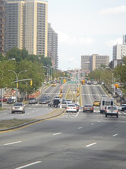
A five-lane stroad on NY 78 (Transit Road) in Amherst, New York, surrounded by auto-oriented commercial development with empty sidewalks
A stroad is a thoroughfare that combines the features of streets and roads.[1][2][3][4] Common in the United States and Canada, stroads are wide arterials (roads for through traffic) that also provide access to strip malls, drive-throughs, and other automobile-oriented businesses (as shopping streets do).[5] Stroads have been criticized by urban planners for safety issues and for inefficiencies. While streets serve as a destination and provide access to shops and residences at safe traffic speeds, and roads serve as a high-speed connection that can efficiently move traffic at high volume, stroads attempt to serve both purposes. They are often an expensive, inefficient, and dangerous compromise.[6][7][8]
In 2011, the American civil engineer and urban planner Charles Marohn, founder of Strong Towns, coined the word "stroad" as a blend of the words street and road to illustrate what he characterized as failures in the North American pattern of development.[4][9][10]
According to Charles Marohn, a stroad is a bad combination of two types of vehicular pathways: it is part street—which he describes as a "complex environment where life in the city happens", with pedestrians, cars, buildings close to the sidewalk for easy accessibility, with many (property) entrances / exits to and from the street, and with spaces for temporary parking and delivery vehicles—and part road, which he describes as a "high-speed connection between two places" with wide lanes and limited entrances and exits, and which are generally straight or have gentle curves.[11]
In essence, Marohn defines a stroad as a high-speed road with many turnoffs, and lacking in safety features.[12][11] In his commentary, Marohn states that stroads do not function well as either a street or a road.[13] According to Marohn, the problem with stroads is that engineering codes tend to emphasize speed and traffic flow rather than safety, so that stroads try to be "all things to all people" but end up failing in every way as a result.[10][14]
Dover and Massengale (2014) stated that the design of roads as highways/motorways was originally modelled on the railroad, namely an efficient connection between two populated places (cities, towns, villages) with a car, while streets formed networks inside a place to move around that place with numerous different modes of transportation to make it financially productive; these two systems functioned well as long they were kept separated,[15]
But when we reconfigure our streets to have the characteristics of roads—as stroads—we are no longer able to capture the value of shar[ing] the space. A modern stroad ... is about the least safe traffic environment you could be in, too, with high-speed designs mashed up with turning traffic, stop-and-go traffic, sudden lane changes, and obnoxious signage. This ridiculously unsafe design is accepted as "normal" just because it was allowed to become ubiquitous.[15]
They noted that the general public is often not aware of the functional distinction that engineers (as well as dictionaries) make between streets and roads, that street names ending with 'street' or 'road' (for historical reasons) may be misleading and not align with the current de facto traffic situation, and that mixing up the functions of streets and roads causes numerous problems.[16]
The concept of the stroad was popularized in large part as a result of an April 2021 short documentary by the Canadian-born Amsterdam-based Jason Slaughter of the urban planning YouTube channel Not Just Bikes, which went viral, and[11][17]:1:02 stated that stroads in North America are "ugly, dangerous, and inefficient", as well as more expensive, contrasting them with road design in the Netherlands, where clear functional distinctions between motorways (highways), roads, and streets were introduced in the 1990s.[18] These measures were aimed at increasing safety, traffic flow, and cost-effectiveness, while also having the effect of reducing car dependency, increasing walkability, cycleability, and general livability.[18] Unlike the two functions ("street" versus "road") proposed by Marohn's foundation Strong Towns,[19] the Dutch Institute for Road Safety Research (Dutch: Stichting Wetenschappelijk Onderzoek Verkeersveiligheid (SWOV), lit.'Foundation (for the) Scientific Study (of) Traffic Safety') identified three functions for roadways in 1994: flow, distribution, and access.[20][18]
Flow roads[21] (Dutch: stroomwegen[22]) are designed to transport lots of people at high speeds.[21] These have been compared to the European and Commonwealth English "motorways" and the U.S. "interstate highways".[21][22]
Distributor roads[21] (Dutch: gebiedsontsluitingswegen[23]) are designed to connect flow roads and access roads.[21] They are not meant to give direct access to private property,[21] and roundabouts are the preferred traffic control option rather than traffic lights.[24]
Access roads[21] (Dutch: erftoegangswegen[25]) are designed to provide access to private property, such as 'homes, offices, industry, farms, shopping centers, and other similar destinations.'[21] According to William Zurborg (2023), access roads 'only connect to distributor roads, and access roads should be positioned to ensure that they are unattractive to through traffic. Access roads are meant to be characterized by their surroundings, and the road itself is meant to harbor people, not deter them.'[21] The design speed (and speed limit) on access roads is 30 kilometres per hour, or lower.[25] The main road users of access roads are pedestrians, cyclists, and public transport travellers; motorists (car drivers) are made aware of these more vulnerable other road users, to better interact with them, and to take a greater responsibility by slowing down.[21] To aid in keeping vehicular speeds relatively safe, physical forms of traffic calming such as narrowing the streets for motor vehicles may also be employed.[25]
The redesigning of roads in the Netherlands into these three functions, as part of the Dutch Sustainable Safety Vision, resulted in a 30% decrease in expected traffic deaths between 1998 and 2007.[21] Zurborg argued that stroads in the United States are the result of local governments designing their roadways to fulfill all three functions simultaneously, thus leading to numerous problems.[26]
In some cases, roads become stroads due to a lack of access management implementation when facilities are expanded or widened, often with the aim of improving mobility. The road becomes a stroad over time from development adding private accessways onto the main road, increasing congestion and collisions, which thus requires traffic control additions such as traffic signals. This degrades the roadway quality in terms of mobility.[27]
According to Charles Marohn, the famous Champs-Élysées in Paris was effectively a stroad as recently as 2001. In the middle of the avenue were three automobile traffic lanes in either direction, ostensibly fulfilling the function of a road. A wide buffer of trees existed on either side of the road area, separating the roadway from slip lanes for slow-driving traffic. These slip lanes fulfilled the function of streets, providing access to parking, sidewalks, shops and restaurants. Because the street and road areas of the Champs-Élysées were physically separated, this stroad environment actually managed some success in allowing both safe high-speed traffic (up to 45 miles per hour (72km/h)) in the center roadway and a productive street environment on the sides. As of 2019[update] however, the slip lanes are fully pedestrianized, while the center roadway functions as a true road.[28][10]:12:01
The Esplanade in Chico, California is, according to Marohn, a rare example of a successful 'stroad' akin to the 2001 version of the Parisian Champs-Élysées in that buffers of trees physically separate the high-speed 'road' part in the middle from the two low-speed productive 'streets' on the sides (lined by houses which had high property values).[29] He contrasted the Esplanade to Mangrove Avenue, a stroad just five blocks to the east in Chico that runs parallel to the Esplanade, but which he claims has the typical issues of a stroad, in that the street and road functions are not physically separated, and the environment is low-density and much less productive, with gas stations, strip malls and other car-oriented businesses.[29]
Unlike Marohn, however, Jason Slaughter of Not Just Bikes does not categorize such traffic situations as a "stroad", but as "a road with streets on either side to access houses".[30] Taking the Nieuwe Dedemsvaartweg (Provincial road N377) outside Nieuwleusen and the Keizer Karelweg(nl) (s108) in Amstelveen in the Netherlands as examples, he used the fact that access from the middle to the sides is very restricted (through a limited number of roundabouts) to argue that they are three separate ways: the middle is a road, the sides are streets; there is no "stroad".[note 1][note 2]
Lack of traffic calming
Northern Boulevard in Queens New York and Old York Road in Elkins Park Pennsylvania showing examples of an urban and suburban stroad respectively
Stroads do not account for human psychology.[33] Vision Zero Coalition's 2018 report explained that since the stroad has a false sense of safety, drivers subconsciously drive at dangerously fast speeds.[34] Stroads in the United States and Canada typically have legal speed limits between 30 and 45 miles per hour (48 and 72km/h). But since the speed limit usually does not match the design speed, motorists usually drive 20 to 55 miles per hour (32 to 89km/h) on stroads.[35] Therefore, simply reducing the posted speed limit (PSL) with a traffic sign, a widely adopted strategy, will not work. "If the road [design] ... suggest[s] that the PSL is too low, drivers may simply ignore it".[33]
To help people comply with the legal speed limit, traffic engineers need to design roads, (stroads,) and streets so that they are self-explanatory.[36] This is called traffic calming. Roads and streets that implement traffic calming measures may use physical and perceptual cues to subconsciously trigger drivers to drive slower and more cautiously due to perceived danger.[37] Examples include "narrower lanes, tighter corner radii, gateway treatments, changed roadway surface materials and appearance, mini roundabouts and other speed management techniques" such as speed bumps.[37] The typical lack of these cues on stroads causes motorists to drive much faster than is safe to do in the environment they are in, with many entries and exits creating points of conflict and potential collisions, especially at higher speeds.[37][note 3]
Traffic engineers in cities around North America (e.g. Boston,[34]Houston,[40]St. Louis,[10] etc.) are reshaping their fundamental street design (and laws) so that safety is prioritized. As of 2019[update], the city of Boston is studying how to minimize pedestrian traffic deaths by lowering speed limits with traffic calming using road diets. After several stroads were replaced by more efficient roadways in Boston, vehicular fatalities fell from 21 in 2016 to 10 in 2018; simultaneously, pedestrian fatalities halved from 14 to 7.[41] This partial success motivated Bostonian locals to demand the complete elimination of the remaining stroads by implementing better road design.[41]
Pedestrian deaths
This section needs expansion. You can help by adding to it. (July 2023)
Queens Boulevard, known in New York City as the Boulevard of Broken Bones, alternatively as the Boulevard of Death, for its frequent pedestrian injuries and deaths
Stroads often lack features designed to make roadways safe for pedestrians, such as crosswalks and adequate street lights. A 2021 report by the Governors Highway Safety Association said that 60.4% of pedestrian fatalities from motor vehicles occurred on such roads.[42]
Car dependency and congestion
Although stroads facilitate the goal of making all destinations reachable by car, they also practically force everyone to use (and own) a car, and thus increase car dependency (at the cost of walkability and easy use of public transport), while not necessarily making travelling by car more efficient.[14][8] Despite the high speeds that stroads were designed for, which has made them needlessly dangerous, in practice they frequently end up being clogged with cars seeking access from the many entrances, so that the average speeds on stroads are low due to traffic congestion.[14] Widening stroads to counter congestion usually only leads to induced demand and extra costs.[8]
The quality of sidewalks (British English: pavement) next to stroads is often poor. Many stroads do not feature any sidewalks at all.[43][44] In the case of stroad-like suburban residential streets, sidewalks are sometimes deliberately left out by design in order "to further the rural image".[14] Whereas stroads often feature a repetitive pattern of retail franchises on the side with very few sidewalks for pedestrians, there are usually large parking spaces for drivers.[45][44] Sometimes there are only "painted sidewalks" next to a strip mall, without curbs or traffic bollards to protect pedestrians against vehicles that may deviate from the road.[46]
Marohn (2021) stated: "A person on a sidewalk has no defense at all if a vehicle leaves the roadway at stroad speeds".[47] He pointed out that traffic lights, such as those next to the State Street stroad in Springfield, Massachusetts, are often designed with shear pins at the base so as to break off if a vehicle happens to crash into it; although this design increases the safety of the driver and any passengers, it also significantly decreases the safety of any pedestrians who may be standing or walking on the sidewalk behind the traffic signal.[48] Marohn was astonished to discover that a bench had placed right next to this breakaway traffic light pole, "inviting people to sit in a place where the chance of a driver losing control and going off the roadway at high speeds is so great that the city installed breakaway poles."[48] At intersecting stroads, vehicles often need to decelerate from a high to a low speed to make a sharp turn right from a long turn lane parallel to the sidewalk; this makes walking there particularly dangerous for pedestrians.[17]:1:35 Sidewalks are sometimes too narrow, feature many obstructions such as street lights, as well as driveway cuts, which make them pedestrian-unfriendly.[17]:4:35
The stroad can be found where urban sprawl and car-centric development patterns are used: it 'seems confused', and is characterized by 'no sidewalk, no shade, and a lot of parking'.[44] In Lexington, Kentucky, where such situations are commonly found in modern suburban commercial areas, a survey of elderly residents found that respondents instead desired 'protection from traffic, reduced noise, seating and shade, dedicated sidewalks, and increased building frontage.'[44]
Walking for a distance of 800 metres (0.50mi) along a stroad (Farm to Market Road 1960 or Cypress Creek Parkway) in Houston motivated Jason Slaughter of Not Just Bikes to reflect upon and criticize the design of the roadway, and explore how urban planning could be done in a more safe and efficient manner (for example, by improving walkability and reducing car dependency).[49]:7:40[50]:4:30, 7:25 The rather narrow sidewalks, and in the middle section (crossing a bridge and a railroad) no sidewalk at all, were right next to fast-driving vehicular traffic (c.80 to 100 kilometres per hour (50 to 62mph), creating an extremely unsafe and unpleasant environment for pedestrians.[49]:8:36[50]:6:03 Yet, the fact that the grass where one would expect a sidewalk was well-trodden, as well as Google Street View images which also appeared to show regular use, was evidence to Slaughter that a significant number of pedestrians apparently saw or had no other option (such as taking a car, taxi or bus) than to walk along this dangerous stroad to get to their destinations without basic pedestrian protections.[50]:6:03, 9:14 He argued: "There is no excuse for this. If you have enough room for 7 lanes of car traffic, then you have enough room for a sidewalk. Or a bicycle path."[50]:9:34
Marohn (2017) stated that stroads "are enormously expensive to build and, ultimately, financially unproductive".[37] This is because "stroads are built to a highway standard, their lanes are very wide, and there are never [fewer] than four lanes",[51] or "at least three through lanes",[17]:1:49 and they usually take up extra space for shoulders and clear zones.[52] Stroads feature many more entrances and exits than limited-access highways and roads and thus require more turning lanes, and because stroad vehicle speeds may be higher than on a street, the turning lanes are much longer to allow vehicles to decelerate and reduce the risk of rear-end collisions; this means stroads require more and longer turning lanes, which are more expensive to build and maintain and take up more space than streets and roads do.[53][17]:3:10 The high frequency of accesses to a stroad with much traffic often prompts the construction of traffic lights at intersections, which may cost up to $250,000 to build (excluding maintenance costs).[53]
An extreme example of this is found on the intersection of Charleston Boulevard with Decatur Boulevard in Las Vegas, which features seven approach lanes, each of which has traffic lights.[17]:2:08 The larger size of stroads compared to streets and roads means they require more space which needs to be purchased, flattened, and asphalted, which reduces the property value of the land, increases the cost of flood protection infrastructure, and adds regular asphalt and traffic control system maintenance costs.[54] Compared to households along urban streets, stroads tend to double the costs that households pay on the construction and maintenance of infrastructure, as well as the delivery of public services, while the tax revenues per acre of properties along stroads are lower compared to urban commercial streets.[14][55]
The space taken up by stroads, as well as the large areas dedicated to parking lots at the destinations of cars using stroads, result in low-density land use (typical for urban sprawl).[56] This makes stroad environments financially significantly less productive and tax-generating than a street, but with significantly more infrastructure and thus high-cost per area maintenance costs, so that they become a net-negative and financial burden for cities, and they cannot therefore sustain themselves.[57]
Improving stroads
Arguing that stroads represent a poor return on investment and safety hazard, Charles Marohn suggested that stroads should either be converted to a street, for land access, or a road, for mobility. Conversion to a street would involve slowing traffic, prioritizing people over cars, and encouraging complex community interactions and solutions. Conversion to a road would involve separating the road from shops and reducing the number of access roads. The Champs-Élysées with its slip lanes is given as an example of one such conversion.[58]
Wonderland Road in London, Ontario, has been identified as a five-lane stroad by Jason Slaughter of Not Just Bikes, who grew up next to it.[8] The city council considered widening Wonderland Road to seven lanes in an attempt to alleviate congestion, but in 2021 it voted 9 to 5 against the plan, because the council majority reasoned that it would only lead to induced demand, 212 million Canadian dollars in construction costs, higher maintenance costs, and a significantly higher environmental impact, without actually solving the congestion problem.[8]
Macleod Trail between Calgary and Fort Macleod in the Canadian province of Alberta, particularly the stretch between the Elbow River and 90 Avenue SE, has been identified as a stroad by Tom Babin ("Shifter").[7] One of the most significant characteristics of this stretch is that this "stroad" part has a rather poor safety record, because it has some of the highest collision rates in the city of Calgary, while at the Macleod Trail part to the north closer to downtown (where it is more like a "street"), as well as the part further to the south (where it is more like a "road"), there were far fewer crashes by comparison.[7]:10:02
United States
The Las Vegas Strip, an infamously clogged stroad, viewed from above at night
Charleston Boulevard, part of the Nevada State Route 159 in Clark County, Nevada, is a stroad in Las Vegas.[17]:0:44 It has at least three through lanes at every point along its length, large intersections such as with Decatur Boulevard (another stroad) and the Interstate 15 (Las Vegas Freeway) where Charleston Boulevard has seven approach lanes, and long right-turn lanes (intended to allow vehicles to decelerate from over 50 miles per hour (80km/h) to safely make a sharp turn right) that make walking on the sidewalk particularly dangerous for pedestrians.[17]:1:35 Pedestrian crossings (crosswalks) over or parallel to Charleston Boulevard tend to be quite long and unsafe,[17]:2:40, 3:42 while sidewalks tend to be narrow, feature many obstructions such as street lights, as well as driveway cuts, which make them pedestrian-unfriendly.[17]:4:35
Georgia State Route 13, also known as the Buford Highway and the Atlanta Highway, is a stroad north of Atlanta, Georgia.[60][46] The Buford Highway community along this stroad, which features many strip malls, is home to a diverse immigrant community where car ownership is low, and the pedestrian fatality rates are amongst the highest in the state of Georgia.[46]As of 2021[update], the Atlanta-based Canvas Planning Group urban community planning and designing consulting firm is co-operating with the local non-profit organisation We Love BuHi to construct 'additional, safer, and more pleasant walking routes by connecting the walkways in front of the many strip malls with painted sidewalks'.[46]
Illinois Route 59 in metropolitan Chicago's DuPage County is a stroad with traffic moving at an average of 50 miles per hour (80km/h), and a repetitive pattern of retail franchises on the side, with very few sidewalks for pedestrians, but large parking spaces for drivers.[45]
Lancaster Avenue in Bryn Mawr, Pennsylvania, has been identified as a stroad, because it is a street designed like a road with expensive infrastructure, low return on investment, and unsafe traffic conditions for both drivers, cyclists and pedestrians.[55]
The Las Vegas Strip is an infamously clogged stroad in Clark County, Nevada, that forms part of the Las Vegas Boulevard (part of Nevada State Route 604).[59][17] According to Ray Delahanty (From the YouTube channel 'CityNerd'), the Las Vegas Strip "is the ultimate stroad", and the word "strip" was a commonly used term to describe "stroads" before Marohn coined the latter term with a specific definition.[17]:0:24
Linn County, Iowa has several stroads, with "Corridor Urbanism" co-founders Bruce Nesmith and Ben Kaplan (2021) pointing to Collins Road, Edgewood Road and Williams Boulevard in Cedar Rapids, as well as Highway 151, Highway 13, Linnview Avenue, Eagleview Drive, Highway 100, East Post Road, Menards Lane, and Seventh Avenue in Marion.[4] They criticized Marion City Council's decision to invest in red light cameras at six intersections of the aforementioned stroads in Marion, while statistics had identified red light running as the cause of only 46 out of all 347 crashes (13.3%) in the previous six years, arguing that redesigning the roads would be a far better solution.[4]
State Street in Springfield, Massachusetts, has been identified as a stroad by Charles Marohn (2021) in a case study involving the death of a seven-year-old girl and the serious injury of her mother and eight-year-old cousin after they were hit by a car on State Street next to the Central Library on December 3, 2014.[61][62][note 4] Marohn stated: 'While many engineers have tried, it is impossible to make a stroad safe. State Street in Springfield has one of the highest crash rates in the state of Massachusetts. The only way to improve safety on a stroad is to convert it into a street or a road.'[64]
Fruitville Road in Sarasota, Florida. In downtown, this stroad is four-lanes before widening to six lanes as it continues east before reverting back to four lanes after the junction with Interstate 75. The road has been subject to traffic signal-induced congestion and frequent incidents of reckless driving.[65]
Other countries
Deagon, Queensland's two main avenues – Sandgate Road / Braun Street (south-north) and Board Street / Depot Road (east-west) – serving as immediate arterial links to the Gateway Motorway, have been identified as 'typical stroads'.[66]
Thailand Highway 3214(th), described by author Korawich Kavee as a stroad.[67]
↑'...a road outside of the town of Nieuwleusen. This road [Provincial road N377] is designed to move vehicles, so there is no direct access to adjacent properties. The homes and businesses are accessed by streets on the right and left side, and the road is mostly accessed by roundabout.'[31] As a matter of fact, the middle road is named 'Nieuwe Dedemsvaartweg', while the northern parallel street is named 'Den Hulst', and the southern parallel street is named 'Rollecate', so they are officially considered separate entities.
↑'Here [on the Keizer Karelweg in Amstelveen], there are several houses, but instead of being accessed directly, as they would be on a stroad, they're accessible by a two-way side street, which was made purposefully narrow to slow down drivers. This also provides a safe alternative for people cycling. The road itself is only two lanes for car traffic, with a turning lane when necessary.'[32] Although both the road and the side street are named 'Keizer Karelweg', only the road has the 's108' ontsluitingsweg designation ('s' stands for 'stadsroute', see s108 (Amsterdam)(nl) and Amsterdam stadsroutes(nl)).
↑'The stroad fails at being a street. There are many driveways to businesses and homes like you'd find on a street, but mixed with multiple highway-sized lanes. This mixes high speeds with many points of conflict.'[38] 'On a stroad, these wide highway-like designs encourage drivers to drive quickly, but combining that with traffic turning in and out of driveways and lots of four-way junctions makes this the most dangerous type of urban driving possible.'[39]
↑Marohn dedicated his 2021 book to the 7-year-old girl who died, and her family's grief, as well as the car driver's conscience: "This book is dedicated to the memory of Destiny Gonzalez and all whose lives have been cut short by America's transportation system, and to Sagrario Gonzalez, her husband, Luis, and all who have suffered great loss on our nation's roads and streets, and to Sandra Zemtsova, along with everyone who must live knowing that others did not. May this book reduce your pain."[63]
References
↑Ross, Jenna (October 8, 2014). Written at Brainerd, MN. "Looking to the Past to Re-Engineer U.S. Towns". Star Tribune. Minneapolis, MN. pp.A1, A6. Retrieved June 21, 2023. A "stroad" is a street/road hybrid that fails to boost value—a street's purpose—or move traffic quickly—a road's job. Or, as Marohn jokes: "It's the futon of transportation."
1234Sarah Fenske (November 1, 2021). "'Recovering engineer' Charles Marohn has a few ideas for St. Louis". St. Louis on the Air. St. Louis Public Radio. Retrieved February 13, 2022. engineering codes prioritize speed and traffic flow over safety ... Marohn is known for coining the term "stroad" ... Stroads try to be all things to all people and generally end up failing on all levels as a result.
↑Allyn West (October 19, 2020). "Achieving Vision Zero in Houston Isn't Going to Happen One Intersection at a Time". The Texas Observer. Retrieved February 13, 2022. ...Behavior is contextual, any sociologist will tell you, and the entire context of the Sun Belt, with its stroads, its SUVS, and its politics of scarcity, is the issue...
↑Cogan, Marin (July 6, 2023). "Why pedestrian deaths in the US are at a 40-year high". Vox. Retrieved July 11, 2023. A stroad is the worst of both worlds, and is incredibly dangerous to pedestrians. The data bears this out: In 2021, the latest GHSA report says, 60.4 percent of pedestrian fatalities happened on such roads, which often lack infrastructure that would make it safe for pedestrians, such as good lighting and frequent crosswalks.
12Clarke, Nicole (October 28, 2020). "Lancaster Avenue: The 'Stroad' Responsible for Holding Bryn Mawr Back from Success". The Villanovan. Retrieved September 16, 2021. A stroad tries to move cars quickly along a corridor of a community. The result is expensive infrastructure serving low-returning properties. A stroad is the worst kind of transportation investment yet, they plague much of the American landscape.
This page is based on this Wikipedia article Text is available under the CC BY-SA 4.0 license; additional terms may apply. Images, videos and audio are available under their respective licenses.