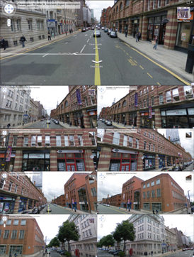
First launched in 2007 in several cities in the United States, Street View has since expanded to include all of the country's major and minor cities, as well as the cities and rural areas of many other countries worldwide. As of 2017, Street View had coverage in 83 countries. Street View has been used for research in fields like urban analytics and geographic information science. Street View imagery has also been used in artistic work.
History
Google Street View car in Germany
Street View had its inception in 2001 with the Stanford CityBlock Project, a Google-sponsored Stanford University research project. The project ended in June 2006, and its technology was folded into Street View.[3] The technology was launched on May 25, 2007, in the United States.
In May 2008, Google announced that it was testing face-blurring technology on its photos of the streets of Manhattan.[4] The technology uses a computer algorithm to search Google's image database for faces and blur them.[5] Street View was integrated into Google Earth 4.3, the Maps application on the Apple iPhone, and the Maps application for the S60 3rd Edition. In November, the drag-and-drop Pegman icon was introduced as the primary user interface element for connecting from Maps' 2D view into Street View's 3D view. When Pegman is dropped onto a particular set of coordinates in Google Maps for which Street View data is available, Street View opens and takes over the whole map window.
In 2009, a full-screen option and Smart Navigation were introduced. Smart Navigation allows users to navigate around the panoramas by double-clicking with their cursor on any place or object they want to see.[6] In May 2011, indoor views of businesses (Google Business Photos) were announced.[7] After the pilot phase of several months, the project was rolled out in autumn.[8]
With the release of Android 4.2 in November 2012, Google invited users to contribute panoramas of their own using supported devices. Google highlights user-contributed panoramas with blue circle icons on Maps. The company also created a website to highlight places in the world where one can find them.[9] In 2013, businesses such as shops, cafés and other premises can pay a photographer to take panoramic images of the interior of their premises, which were then included in Street View.[10] Google sets up a program to let third parties borrow the Street View Trekker (a backpack-mounted camera).[11] Business interior views are shown as small orange circles. In 2014, Street-level imagery from the past can now be optionally seen, if available, for a given street view.[12]
In 2015, a partnership was announced between Street View and the environmental monitoring company Aclima. Cars carry sensors to detect pollutants such as nitrogen dioxide, ozone, and particulates.[13] In October, support for Google Cardboard was announced, allowing users to utilize Street View in 360-degree virtual reality.[14]
In 2017, imagery inside the International Space Station was added to Street View. In August 2017, Google also allowed users to create their own Street View-like blue paths for the connected photospheres that are sufficiently close to one another.
On September 5, 2017, Google announced that they were improving the quality of the street view panoramic photo by revamping its mapping vehicles with all-new high-resolution camera systems and artificial intelligence. The new Google cars have been seen in various American cities since March 2017, as well as in Japan since August.[15] The first images taken with the new generation of cameras were available online on September 13.[16] In October 2017, the makers of the Insta360 Pro announced the certification of the first "Street View auto ready" camera for US$3,500; it uses six lenses for a 360° view and comes with Stitcher software.[17] In addition to purchase, the camera rig is also available to qualified entities as part of the Google loaner program, with 50 cameras available to loan.[18]
On December 3, 2020, Google announced that users could contribute to Street View by capturing video using their augmented reality-supported phones using the Street View app.[21][22] Google shut down its dedicated Street View app on Android and iPhone and ended support on March 21, 2023. The Street View app allowed users to take and publish their own 360° photos. Google says that users can still upload 360° photos using StreetView Studio.[23]
Parallel to its own collection efforts, Google managed a Street View Trusted program, which certified independent photographers and agencies to contribute high-quality panoramic imagery, particularly for businesses wanting "See Inside" tours. The program provided photographers with a "Trusted" badge and a listing in an official directory. In mid-2024, Google officially phased out the "Trusted" program and certification, shifting its focus to the broader user-contribution tools available in Street View Studio.[24] Notably, while the program is no longer active and no new certifications are being issued, the legacy directory of previously certified "Trusted Photographers" remains visible on Google's website.[25]
The drag-and-drop Pegman icon is the primary user interface element used by Google to connect Maps to Street View. Its name comes from its resemblance to a clothespeg. When not in use, Pegman sits atop or beside the Google Maps zoom controls. Occasionally, Pegman "dresses up" for special events or is joined by peg friends in Google Maps. When dragged into Street View near Area 51, he becomes a flying saucer, and when dragged near the Florida Keys or Hawaii, he becomes a mermaid. When viewing older views, the Pegman in the minimap changes to Doc Brown from Back to the Future.[32] At Loch Ness, Pegman turns into Nessie wearing a tartan hat, where Street View includes coverage of the lake itself as well as the nearby A82 road and rural areas.[33]
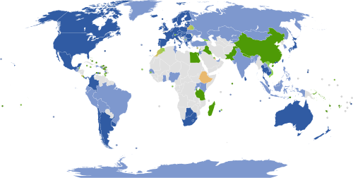
Countries and dependencies with mostly full coverage
Countries and dependencies with partial coverage
Countries and dependencies with official coverage planned
Countries and dependencies with unofficial coverage planned
Countries and dependencies with views of selected businesses and/or tourist attractions only
Countries and dependencies with views of third party images of streets and/or landmarks
Countries and dependencies without current or planned coverage
Google announced in May 2017 that it had captured more than 10million miles (16million kilometres) of Street View imagery across 83 countries.[34][35] Maps also include panoramic views taken underwater such as in West Nusa Tenggara underwater coral, in the Grand Canyon, inside museums, and Liwa Desert in United Arab Emirates, which is viewed from camelback.[36] In a ten-day trek with Apa Sherpa, Google documented Khumbu, Nepal with its Mount Everest, Sherpa communities, monasteries and schools.[37]
In June 2022, Google announced the company is relaunching their Street View service in India. The announcement came six years after the feature was banned in India over security concerns. The company has partnered with local technology businesses Tech Mahindra and Genesys to aid in the relaunch of the service. As of July2022[update], the service is live in 10 cities in India.[38]
In late 2024, Google announced a significant expansion of its coverage in Africa, using the latest generation of Street View cars and third-party contributors to add more than 70,000 kilometers of roads in Rwanda and Nigeria, with a stated goal of improving logistics and local commerce.[39] Further expansions in rural areas of Australia and Canada were also rolled out through early 2025, focusing on previously unmapped regions.[40]
Official coverage made by Google (excluding third parties or unofficial)
R2: the earliest after Immersive Media. The photos were captured with a ring of eight 11-megapixel CCD sensors with commercial photographic wide-angle lenses, cameras with the same specifications as those used for the Google Books project.
Ladybug2 cameras (resolution 1024 × 768 pixels) by Point Grey Research.[44]
R5: uses a ring of eight 5-megapixel CMOS cameras by Elphel[45][46] with custom low-flare lenses, plus a camera with a fisheye lens on top to capture upper levels of buildings.
R7: the first completely in-house-built camera; it uses 15 of the same sensors and lenses as R5, without the fisheye effect.
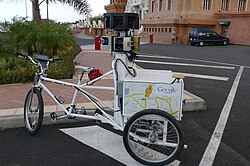
Data-recording equipment is usually mounted on the roof of a car. A trike (tricycle) was developed to record pedestrian routes, including Stonehenge and other UNESCOWorld Heritage Sites. In 2010, a snowmobile-based system captured the 2010 Winter Olympics sites.[43] Shopping trolleys have also been used to shoot the insides of museums, and in Venice, the narrow roads were photographed with backpack-mounted cameras, and canals were photographed from boats.[47] A portable backpack-mounted Google Trekker is used in outdoor terrain. For instance, the six main paths up Snowdon, United Kingdom, were mapped by the Google Trekker in 2015.[48]
In 2017, Google used eight 20-megapixel cameras. Two cameras were facing left and right to read street signs and business names.[49]Laser range scanners from Sick AG for measuring up to 50 meters at 180° in the front of the vehicle[50] are used for recording the actual dimensions of the space being photographed. LIDAR scanners from Velodyne were added in the 2017 update. It is mounted at 45° to capture three-dimensional depth information and positional information.[49] Accurate positioning was done via a Global Positioning System, a wheel speed sensor, and inertial navigation sensor data.[43]
In September 2018, Google announced it would integrate air quality sensors from Aclima into its global fleet of Street View vehicles.[51]
A Street View Trekker backpack-mounted cameraGoogle Maps Street View Trekker backpack being implemented on the sidewalk of the Hudson River Greenway in New York City
In addition to Google's own equipment, a wide range of third-party 360° cameras are certified as "Street View Ready," allowing professionals and individuals to contribute imagery. These systems, such as the Matterport Pro2, are often used in tripod-based setups for high-resolution stationary panoramic captures of both interiors and outdoor landmarks.[52]
The Matterport Pro2, a popular third-party "Street View Ready" camera, being used for environmental mapping at Dal Lake, Srinagar.
Google Street View will blur content for any user who makes a request, in addition to the automatic blurring of faces and licence plates.[53] Privacy advocates have objected to Google Street View, pointing to views found to show men leaving strip clubs, protesters at an abortion clinic, sunbathers in bikinis, and people engaging in activities visible from public property that they do not wish to be seen publicly.[54] Another concern is the height of the cameras, and in at least four countries, Japan[55] Switzerland,[56] Sri Lanka and Liechtenstein, Google has had to lower the height of its cameras so as to not peer over fences and hedges. The service also allows users to flag inappropriate or sensitive imagery for Google to review and remove.[57] On the other side of the blurring issue are those who wish their home or property to be unblurred. As of 2023, there is no process to have an image or object in Street View unblurred.[58]
Police Scotland received an apology for wasting police time in 2014 from a local business owner in Edinburgh who, in 2012, staged a fake murder for the Google camera car by lying in the road "while his colleague stood over him with a pickaxe handle".[59] In May 2010, it was revealed that Google had collected and stored payload data from unencrypted Wi-Fi connections as part of Street View.[60][61]
In November 2024, Spanish police arrested two people in connection with a man's disappearance and death after discovering a Google Street View image—captured in October in the village of Tajueco, Soria—that appears to show a person loading a large object into the trunk of a car.[62]
The concerns have led to Google not providing or suspending the service in countries around the world.
Austria: Google Street View was banned in Austria, because Google was found to collect Wi-Fi data without authorization in 2010. After the ban was lifted, rules were set up for how Street View can operate legally in Austria. Google resumed collecting imagery in 2017.[63] As of 2018 Google Street View is available in select areas of Austria.
Australia: In 2010, Google Street View ceased operations in Australia, following months of investigations from Australian authorities.[64] However, this cessation has since ended, with Google announcing plans to continue production on May 4, 2011[65] and subsequently releasing updated Street View imagery for Australian towns and cities on July 27, 2011.[66]
Germany: In 2011, having put online pictures of the 20 largest cities, Google stopped taking Street View images in Germany.[67] However, as of mid-2020, Google's website shows numerous areas of Germany as being scheduled for coverage by Street View vehicles over the ensuing months.[68] As of 2024, Germany has partial street coverage.
India: In 2011, Google stopped taking street images in India, after receiving a letter from police authorities in Bangalore.[69] However, in 2022, Google announced Street View in eight Indian cities, including Bangalore.[70]
Canada: Street View cars were spotted as early as September 2007 in Montreal. However, service for Canada was delayed while they attempted to settle with the Canadian government over its privacy laws. Privacy and town beauty concerns were dealt with and Street View is available in Montreal and other Canadian cities (as of 2016).[71]
Third-party use of images
Imagery obtained from Google Street View has been used for research purposes, e.g., quantifying greenery, health studies, and assessing cycling conditions.[72][73]
Michael Wolf won an honourable mention in Daily Life in the 2011 World Press Photo competition for some of his work using Google Street View.[77]Mishka Henner was shortlisted for the 2013 Deutsche Börse Photography Prize in November 2012 for his series 'No Man's Land', which depicts sex workers at rural roadside locations.[78] Canadian artist Sylvia Grace Borda worked in conjunction with John M. Lynch between 2013 and 2014[79][80] to insert the first staged tableaux[81] into the Google Street View engine. It won them the Lumen Prize in 2016.[82] Borda has independently continued to author the Google Street View engine, and in 2017, she created the tableaux series the Kissing Project.[83]
Swedish programmer Anton Wallén developed a game called GeoGuessr, which places players in a Google Street View and has them guess its location.[84] In 2022, competitive players went viral, prompting a New York Times feature on top players.[85]
Gallery
The cameras of this Google Street View car are mounted on the roof rack. The power and data cables are fed into the car through the right rear passenger window.
This page is based on this Wikipedia article Text is available under the CC BY-SA 4.0 license; additional terms may apply. Images, videos and audio are available under their respective licenses.