
Tel Aviv-Yafo, usually referred to as just Tel Aviv, is the most populous city in the Gush Dan metropolitan area of Israel. Located on the Israeli Mediterranean coastline and with a population of 474,530, it is the economic and technological center of the country and a global High tech hub. If East Jerusalem is considered part of Israel, Tel Aviv is the country's second-most-populous city, after Jerusalem; if not, Tel Aviv is the most populous city, ahead of West Jerusalem.

Google Earth is a computer program that renders a 3D representation of Earth based primarily on satellite imagery. The program maps the Earth by superimposing satellite images, aerial photography, and GIS data onto a 3D globe, allowing users to see cities and landscapes from various angles. Users can explore the globe by entering addresses and coordinates, or by using a keyboard or mouse. The program can also be downloaded on a smartphone or tablet, using a touch screen or stylus to navigate. Users may use the program to add their own data using Keyhole Markup Language and upload them through various sources, such as forums or blogs. Google Earth is able to show various kinds of images overlaid on the surface of the Earth and is also a Web Map Service client. In 2019, Google revealed that Google Earth now covers more than 97 percent of the world, and has captured 10 million miles of Street View imagery.

The Savoy Hotel attack was a terrorist attack by the Palestine Liberation Organization against the Savoy Hotel in Tel Aviv, Israel, on 5–6 March 1975.
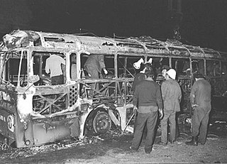
The Coastal Road massacre occurred on 11 March 1978, when Palestinian militants hijacked a bus on the Coastal Highway of Israel and murdered its occupants; 38 Israeli civilians, including 13 children, were killed as a result of the attack while 76 more were wounded. The attack was planned by the influential Palestinian militant leader Khalil al-Wazir and carried out by Fatah, a Palestinian nationalist party co-founded by al-Wazir and Yasser Arafat in 1959. The initial plan of the militants was to seize a luxury hotel in the Israeli city of Tel Aviv and take tourists and foreign ambassadors hostage in order to exchange them for Palestinian prisoners in Israeli custody.

On 1 June 2001, a Hamas-affiliated terrorist blew himself up outside the Dolphinarium discotheque on the beachfront in Tel Aviv, Israel, killing 21 Israelis, 16 of whom were teenagers. The majority of the victims were Israeli teenage girls whose families had recently immigrated from the former Soviet Union.
The Pi Glilot bombing was an attempt by a Palestinian terrorist to cause a massive explosion in the Pi Glilot LPG depot north of Tel Aviv, Israel. It occurred on May 23, 2002. The attempt was foiled with no injuries, but if it had succeeded, it could have killed thousands of people in a massive fireball.

A successful paramilitary campaign, sometimes referred to as the Palestine Emergency, was carried out by Zionist underground groups against British rule in Mandatory Palestine from 1944 to 1948. The tensions between the Zionist underground and the British mandatory authorities rose from 1938 and intensified with the publication of the White Paper of 1939. The Paper outlined new government policies to place further restrictions on Jewish immigration and land purchases, and declared the intention of giving independence to Palestine, with an Arab majority, within ten years. Though World War II brought relative calm, tensions again escalated into an armed struggle towards the end of the war, when it became clear that the Axis powers were close to defeat.

The State of Israel and the Islamic Republic of Pakistan have never had formal diplomatic relations. In 1947, Pakistan voted against the United Nations Partition Plan for Palestine, and currently does not recognize Israeli sovereignty. Despite the Pakistani position on the Arab–Israeli conflict, there have been multiple instances of the two countries closely cooperating during events such as the Soviet–Afghan War and the Black September conflict. With regard to the Israeli–Palestinian conflict, Pakistan supports the Palestinian Arabs and endorses the two-state solution. The Pakistani government has maintained that it will not pursue a normalized relationship with Israel until the establishment of an independent Palestinian state within the pre-1967 borders and with East Jerusalem as the Palestinians' capital city. Nevertheless, with Turkey serving as their middle ground, Israel and Pakistan have used their embassies and consulates-general in the cities of Ankara and Istanbul to communicate and exchange necessary information with each other. In 2010, the Pakistani newspaper Dawn reported that Pakistan's Inter-Services Intelligence, following up on reports received in Washington, had gone through Ankara to pass on newly discovered information to Israel's Mossad about an upcoming terrorist attack in Mumbai, India, where a Jewish cultural centre was listed as a major target; this information first surfaced on WikiLeaks one year after the 2008 Mumbai attacks were carried out by Lashkar-e-Taiba, a Pakistan-based terrorist organization.
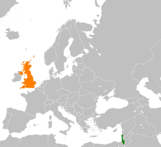
Israel–United Kingdom relations, or Anglo-Israeli relations, are the diplomatic and commercial ties between the United Kingdom and Israel. The British embassy to Israel is located in Tel Aviv. The UK has an honorary consul in Eilat and a non-accredited consulate-general in Jerusalem, that represents the United Kingdom in that city and the Palestinian territories. Israel has three representative offices in the United Kingdom: an Embassy located in London and consulates in Cardiff and Glasgow.
Privacy advocates have objected to the Google Street View feature, pointing to photographs that show people leaving strip clubs, protesters at an abortion clinic, sunbathers in bikinis, cottagers at public parks, people picking up prostitutes, and people engaging in activities visible from public property which they do not wish to be photographed and have published online. Google maintains that the photos were taken from public property. However, this does not take into account that the Street View cameras take pictures from an elevated position, enabling them to look over hedges and walls designed to prevent some areas from being open to public view. Before launching the service, Google removed photos of domestic violence shelters, and additionally allows users to flag inappropriate or sensitive imagery for Google to review and remove. When the service was first launched, the process for requesting that an image be removed was not trivial. Google changed its policy to make removal more straightforward, but has since removed the option to request removal of an image, replacing it by an option to request blurring of an image. Images of potential break-ins, sunbathers, and individuals entering adult bookstores have, however, remained active and these images have been widely republished.

In Asia, Google Street View is available in Bangladesh, Bhutan, British Indian Ocean Territory, Brunei, Cambodia, Hong Kong, Indonesia, Israel, India, Japan, Jordan, Kazakhstan, Kyrgyzstan, Laos, Lebanon, Macau, Malaysia, Mongolia, the Philippines, Qatar, Russia, Singapore, South Korea, Sri Lanka, Taiwan, Thailand, Turkey and the United Arab Emirates. This includes disputed territories in both Israel and India. It is also available for a few select tourist attractions in the People's Republic of China, Iraq, Nepal and Pakistan.

The Branch Office of the Embassy of the United States of America in Tel Aviv is part of the diplomatic mission of the United States in the State of Israel. The complex opened in 1966, and is located at 71 HaYarkon Street in Tel Aviv. It served as the United States Embassy until May 14, 2018, when the seat of embassy was relocated to Jerusalem.
The 2011 Tel Aviv nightclub attack was a combined vehicular assault and stabbing attack which occured on 29 August 2011 when a Palestinian attacker stole an Israeli taxi cab and rammed it into a police checkpoint guarding the popular nightclub, Haoman 17, in Tel Aviv which was filled with 2,000 Israeli teenagers. After crashing into the checkpoint, the attacker jumped out of the vehicle and began stabbing people. Four civilians, four police officers, and the assailant were injured in the attack. The assailant was living illegally in Israel at the time of the attack.
The 2012 Burgas bus bombing was a terrorist attack carried out by a suicide bomber on a passenger bus transporting Israeli tourists at the Burgas Airport in Burgas, Bulgaria, on 18 July 2012. The bus was carrying 42 Israelis, mainly youths, from the airport to their hotels, after arriving on a flight from Tel Aviv. The explosion killed the Bulgarian bus driver and five Israelis and injured 32 Israelis, resulting in international condemnation of the bombing.

The 2012 Tel Aviv bus bombing was a mass-injury terror attack carried out on November 21, 2012, on a crowded passenger bus driving in the center of Tel Aviv's business district. The attack was carried out by an Israeli citizen of Arab descent, who remotely detonated an explosive device, which he had hid on the bus in advance. Twenty-eight civilians were injured in the attack, among them three who were injured seriously. The attack was carried out on the 8th and last day of Operation Pillar of Defense, only a few hours before the ceasefire was reached.
Sergeant Almog Shiloni of the Israel Defense Forces was killed on 10 November 2014 after he was stabbed multiple times at Tel Aviv HaHagana Railway Station. He died in hospital from his wounds. Shiloni was off-duty, but in uniform and armed at the time.

An increase of violence occurred in the Israeli–Palestinian conflict starting in the autumn of 2015 and lasting into the first half of 2016. It was called the "Intifada of the Individuals" by Israeli sources, the Knife Intifada, Stabbing Intifada or Jerusalem Intifada by international sources because of the many stabbings in Jerusalem, or Habba by Palestinian sources. 38 Israelis and 235 Palestinians were killed in the violence. 558 Israelis and thousands of Palestinians were injured.

In a terrorist attack in Tel Aviv, Israel on 8 June 2016, two Palestinian gunmen opened fire on patrons at the Max Brenner Cafe at the Sarona Market, killing four people and injuring seven others. The perpetrators were caught alive by the security forces and put in custody. According to an official indictment filed by the Tel Aviv District Prosecutor's Office the perpetrators were inspired by the Islamic State group.
On 9 October 2016 in Jerusalem, Musbah Abu Sbaih, a Hamas militant shot 8 people from a car near the Ammunition Hill light rail stop, killing two and wounding six. The police gave chase, Shaih was shot and killed while shooting at pursuing police.

On 7 April 2022, a mass shooting took place on Dizengoff Street in Tel Aviv, Israel. Three Israeli civilians were killed and 6 were injured.
