Sunken lane

Last updated
A hollow way (chemin creux) at La Meauffe, Manche, France La Meauffe - Chemin creux 1.JPG
A hollow way (chemin creux) at La Meauffe, Manche, France

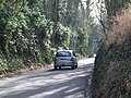
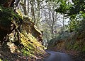
A sunken lane (also hollow way or holloway) is a road or track that is significantly lower than the land on either side, not formed by the (recent) engineering of a road cutting but possibly of much greater age.

Contents

Holloways may have been formed in various ways, including erosion by water or traffic; the digging of embankments to assist with the herding of livestock; and the digging of double banks to mark the boundaries of estates.

Means of formation

A variety of theories have been proposed for the origins of holloways. Different mechanisms may well apply in different cases.

Erosion

Some sunken lanes are created incrementally by erosion, by water and traffic. Some are ancient, with evidence of Roman or Iron Age origins, but others such as the Deep Hill Ruts in the old Oregon Trail at Guernsey, Wyoming, developed in the space of a decade or two. [1]

Where ancient trackways have lapsed from use, the overgrown and shallow marks of hollow ways through forest may be the sole evidence of their former existence. On disused ridgeways in central Germany, the hollow ways often mark inclines. [2]

The earth banks on either side, sometimes topped with hedges and trees, can give the impression of a tunnel enclosing the traveller. Because the roadway is restricted by the banks on either side, sunken lanes typically admit the passage of only one vehicle; that is, they are single track roads. Occasional passing places may be provided, but a meeting of vehicles in a sunken lane often requires one party to reverse to a suitable passing place. In Central Germany, "dual carriageways" have been observed with two trenches side by side where a trackway was in such heavy use that it had lanes dedicated for each direction. [2]

Embankments for cattle

Up to the present day, some writers have assumed that low banks were deliberately created with shovels as a means to hem in cattle, [3] but there is no evidence for this, and in any case, banking only appears intermittently in certain types of soil[ citation needed ]. When metalled, sunken lanes are unlikely to erode further.

Double boundary banks

In The Making of the English Landscape , W. G. Hoskins explains the origin of some English holloways as a pair of matched earth banks marking the boundaries of two landowners' estates, as evidenced by the "two-fold ditch", twifealda dich in a charter of c. 1174 describing the boundary between the abbot of Tavistock's land at Abbotsham, Devon and Richard Coffin's land at Alwington and Cockington. He gives another example, also from Devon, in a photograph of Armourwood Lane, Thorverton, which bounded the royal Silverton estate and the estate of Exeter abbey, most likely in the seventh century. Hoskins states that some such lanes are Celtic, some Saxon, some mediaeval. [4]

In different countries

Belgium

A sunken lane extending across the battlefield played an important role in the Battle of Waterloo in 1815, particularly in presenting an obstacle to the French cavalry. [5] Victor Hugo dramatized this episode in Les Misérables . [6]

France

Sunken lanes are common in the West of France, in the bocage landscape, especially around Lower Normandy, Brittany and Anjou. The bocage landscape is historically famous for having been a particular feature of some conflicts, including the Chouannerie, [7] or more recently the Battle of Normandy. The German army used sunken lanes to implement strong points and defenses to stop the American troops on the Cotentin peninsula and around the town of Saint-Lô. [8]

One such lane, the Sunken Lane at Hawthorn Ridge west of Beaumont Hamel in northern France, is remembered as an assembly point for British troops, many of whom were filmed there on the first day on the Somme (1 July 1916) by Geoffrey Malins for the film The Battle of the Somme .

Germany

One of the largest networks of such routes in Germany is to be found in the municipalities of Alsheim and Mettenheim in Rhineland-Palatinate, where there they make up over 30 km of hiking trails. Some of these sunken lanes can be up to 5 metres deep. [9]

Spain

Congostra da Carballa, Ribeira, Galicia, Spain Profunda congostra.jpg
Congostra da Carballa, Ribeira, Galicia, Spain

In Galicia and western Asturias (both regions of northern Spain) the sunken lanes are usually called congostras or corredoiras, from Latin coangusta 'confined' and curro, currere 'run', being a common and characteristic feature of rural areas. Some lanes are now being recovered as hiking trails.[ citation needed ]

Syria

In Syria, faint traces of hollow ways attest to a dense network of tracks or paths connecting Bronze Age sites with each other and with their cultivation zones in the fourth and third millennia BC, and thousands of kilometres of such routes have been surveyed. [10]

United Kingdom

Sunken lanes are a characteristic feature of the landscape of southern England, especially in the chalk areas of the North and South Downs, and greensand areas such as the Weald. The Surrey Hills AONB has many sunken lanes. Seal Hollow Road in Sevenoaks is a fine example of a sunken lane in southern England.[ citation needed ]

They are a particular feature of the West Country, in counties such as Dorset, [11] and west Wales – areas unaffected by the land enclosures of mediaeval England. [12] The English name holloway (hollow-way) derives from the Old English "hola weg", a sunken road. [11]

While many sunken lanes are now metalled, some are still unsurfaced green lanes, typically now designated as either bridleways or byways.

A sunken road is a cross country equestrian obstacle.

See also

Related Research Articles

<span class="mw-page-title-main">Bocage</span> Terrain of mixed woodland and pasture

Bocage is a terrain of mixed woodland and pasture characteristic of parts of northern France, southern England, Ireland, the Netherlands, northern Spain and northern Germany, in regions where pastoral farming is the dominant land use.

<span class="mw-page-title-main">Pease Pottage</span> Human settlement in England

Pease Pottage is a village in the Mid Sussex District of West Sussex, England. It lies on the southern edge of the Crawley built-up area, in the civil parish of Slaugham.

<span class="mw-page-title-main">Witley</span> Village in England

Witley is a village and civil parish in the Borough of Waverley in Surrey, England centred 2.6 miles (4 km) south west of the town of Godalming and 6.6 miles (11 km) southwest of Guildford. The land is a mixture of rural contrasting with elements more closely resembling a suburban satellite village.

<span class="mw-page-title-main">Pilgrims' Way</span> Historic walking route in England

The Pilgrims' Way is the historical route supposedly taken by pilgrims from Winchester in Hampshire, England, to the shrine of Thomas Becket at Canterbury in Kent. This name, of comparatively recent coinage, is applied to a pre-existing ancient trackway dated by archaeological finds to 600–450 BC, but probably in existence since the Stone Age. The prehistoric route followed the "natural causeway" east to west on the southern slopes of the North Downs.

<span class="mw-page-title-main">Green lane (road)</span>

A green lane is a type of road in the United Kingdom, usually an unmetalled or unpaved rural route.

<span class="mw-page-title-main">History of Leicestershire</span> Aspect of history

This article is intended to give an overview of the history of Leicestershire.

<span class="mw-page-title-main">Historic roads and trails</span> Historical trail or road

Historic roads are paths or routes that have historical importance due to their use over a period of time. Examples exist from prehistoric times until the early 20th century. They include ancient trackways, long-lasting roads, important trade routes, and migration trails. Many historic routes, such as the Silk Road, the Amber Road, and the Royal Road of the Persian Empire, covered great distances and their impact on human settlements remain today.

<span class="mw-page-title-main">St Helier, London</span> Housing estate in London

St Helier is a residential cottage estate in the London boroughs of Merton and Sutton. The portion of the estate north of Green Lane and Bishopsford Road is in Merton, the remainder is in Sutton.

<span class="mw-page-title-main">Earlswood</span> Human settlement in England

Earlswood is a suburb of Redhill in Surrey, England, which lies on the A23 between Redhill and Horley. Earlswood Common is a local nature reserve that separates the suburb from the southern outskirts of Reigate and has two lakes and picnic areas. Earlswood station is on the Brighton Main Line. To the east of the line are Royal Earlswood Park, the East Surrey Hospital and Whitebushes.

<span class="mw-page-title-main">Nonsuch Park</span> Public park in Stoneleigh, Surrey, England

Nonsuch Park is a public park between Stoneleigh, Cheam, and Ewell in the borough of Epsom and Ewell in Surrey, England. It borders the London Borough of Sutton. It is the last surviving part of the Little Park of Nonsuch, a deer hunting park established by Henry VIII surrounding the former Nonsuch Palace.

<span class="mw-page-title-main">Maudslay State Park</span> Massachusetts state park located in Newburyport

Maudslay State Park is a Massachusetts state park located in Newburyport. The park is managed by the Department of Conservation and Recreation. It is available for weddings and other programs.

<span class="mw-page-title-main">A286 road</span> Road in the south east of England

The A286 is an A class road in the south of England, from its northernmost point in Milford, Surrey, to Birdham, West Sussex. It passes through the market towns of Haslemere and Midhurst, and the cathedral city of Chichester. The road is mostly single carriageway, with a small dual carriageway section as part of the Chichester ring road.

<span class="mw-page-title-main">Swinley Forest</span> Woodland in Southern England

Swinley Forest is a large expanse of Crown Estate woodland managed by Forestry England mainly within the civil parishes of Windlesham in Surrey and Winkfield and Crowthorne in Berkshire, England.

Witley Park, formerly known as Lea Park, is an estate dating from the late 19th century between Godalming and Haslemere in Surrey, England. Its landscaped grounds include three artificial lakes, one of which conceals an underwater conservatory and smoking room. The mansion house, rebuilt for the swindler Whitaker Wright, was gutted by fire in October 1952 and the ruins were demolished in January 1954. In the early 21st century, a new house was built on the site.

<span class="mw-page-title-main">Dispersed settlement</span> Rural settlement type

A dispersed settlement, also known as a scattered settlement, is one of the main types of settlement patterns used by landscape historians to classify rural settlements found in England and other parts of the world. Typically, there are a number of separate farmsteads scattered throughout the area. A dispersed settlement contrasts with a nucleated village. It can be known as main human settlements.

Ellisfield is a village in the Basingstoke and Deane district of Hampshire, England. It lies approximately 4 miles (6.4 km) south of Basingstoke on the other side of the M3 motorway from the town. As a parish it is grouped together with Cliddesden, Dummer and Farleigh Wallop.

<span class="mw-page-title-main">Devon hedge</span>

A Devon hedge, also known as a Devon hedgebank, consist of a rubble or earth bank that is usually topped with bushy shrubs forming a hedgerow, with trees also being a frequent and noticeable feature. The bank may be faced with turf or stone.

Ridgeways are a particular type of ancient road that exploits the hard surface of hilltop ridges for use as unpaved, zero-maintenance roads, though they often have the disadvantage of steeper gradients along their courses, and sometimes quite narrow widths. Before the advent of turnpikes or toll roads, ridgeway trails continued to provide the firmest and safest cart tracks. They are generally an opposite to level, valley-bottom, paved roads, which require engineering work to shore up and maintain. Unmaintained valley routes may require greater travelling distances than ridgeways.

<span class="mw-page-title-main">Ulnaby</span> Human settlement in England

Ulnaby is an abandoned village and scheduled ancient monument in the grounds of Ulnaby Hall Farm, near High Coniscliffe, County Durham, England. The toft village was occupied from the late-13th to the 16th century and temporary buildings were erected in the 19th century. Ulnaby Hall farm appears to have been built in the late-16th century, supplanting a high status medieval manorial enclosure associated with the original village. It is thought that the village shrank because of the change from labour-intensive arable farming to pasture, before being abandoned and the site was subsumed into the farm as pasture.

<i>The Making of the English Landscape</i> Book about history of Englands landscapes by William George Hoskins

The Making of the English Landscape is a 1954 book by the English local historian William George Hoskins. The book is also the introductory volume in a series of the same name which deals with the English Landscape county by county.

References

  1. Kreutzer, Lee (2008). "National Historical Trails: Across Wyoming, US National Park System" (PDF).
  2. 1 2 Nicke, Herbert: Vergessene Wege, Nümbrecht: Martina Galunder Verlag, 2001
  3. Inglis, Harry RG: "The Roads Leading to Edinburgh", PSAS, vol. 50, (1915-16), pp. 18-49
  4. Hoskins, W. G. (1970). The Making of the English Landscape (1st pub. 1955). Penguin. pp. 31–32 and plate 13.
  5. Barbero, Alessandro (2005), The Battle: A New History of Waterloo (p. 426, note 18) Atlantic Books, ISBN   1-84354-310-9
  6. Hugo, Victor (1862), "Part 2, Book 1, Chapter 7: Napoleon in a Good Humor", Les Misérables , The Literature Network, archived from the original on 12 October 2007, retrieved 14 September 2007
  7. Michel Moulin, Mémoires de Michelot Moulin sur la Chouannerie normande, A. Picard, 1893, pp.88–89
  8. George Bernage, Objectif Saint-Lô : 7 juin-18 juillet 1944, Edition Heimdal, 2012, p.97
  9. "Initiative Mettenheimer Hohlwege". Heimat und Kulturverein Mettenheim. Retrieved 27 May 2014.
  10. Raccidi, Mattia (2013). "Wagons on the Move. The Study of Wagons through Landscape Archaeology". Quaternary International. 312: 12–26. Bibcode:2013QuInt.312...12R. doi:10.1016/j.quaint.2013.08.018.
  11. 1 2 Macfarlane, Robert (25 August 2007). "A Lost Wilderness". The Daily Telegraph. Retrieved 27 May 2014.
  12. Pryor, Francis. The Making of the British Landscape: How We Have Transformed the Land, from Prehistory to Today. Penguin, 2011.

Bibliography