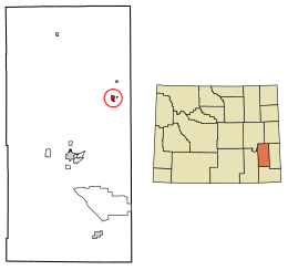
Guernsey, Wyoming | |
---|---|
Coordinates: 42°16′2″N104°44′35″W / 42.26722°N 104.74306°W | |
Country | United States |
State | Wyoming |
County | Platte |
Area | |
• Total | 1.04 sq mi (2.69 km2) |
• Land | 1.02 sq mi (2.65 km2) |
• Water | 0.01 sq mi (0.04 km2) |
Elevation | 4,354 ft (1,327 m) |
Population | |
• Total | 1,147 |
• Estimate (2019) [3] | 1,124 |
• Density | 1,096.59/sq mi (423.54/km2) |
Time zone | UTC-7 (Mountain (MST)) |
• Summer (DST) | UTC-6 (MDT) |
ZIP code | 82214 |
Area code | 307 |
FIPS code | 56-34320 [4] |
GNIS feature ID | 1589181 [5] |
Website | http://townofguernseywy.us/ |
Guernsey is a town in Platte County, Wyoming, United States. The population was 1,147 at the 2010 census.
The town was named for C. A. Guernsey, a cattle rancher. [6]
Guernsey is located at 42°16′2″N104°44′35″W / 42.26722°N 104.74306°W (42.267251, −104.743187). [7]
According to the United States Census Bureau, the town has a total area of 1.04 square miles (2.69 km2), of which 1.02 square miles (2.64 km2) is land and 0.02 square miles (0.05 km2) is water. [8]
Census | Pop. | Note | %± |
---|---|---|---|
1910 | 274 | — | |
1920 | 372 | 35.8% | |
1930 | 656 | 76.3% | |
1940 | 603 | −8.1% | |
1950 | 721 | 19.6% | |
1960 | 800 | 11.0% | |
1970 | 793 | −0.9% | |
1980 | 1,512 | 90.7% | |
1990 | 1,155 | −23.6% | |
2000 | 1,147 | −0.7% | |
2010 | 1,147 | 0.0% | |
2019 (est.) | 1,124 | [3] | −2.0% |
U.S. Decennial Census |
As of the census [2] of 2010, there were 1,147 people, 504 households, and 315 families living in the town. The population density was 1,124.5 inhabitants per square mile (434.2/km2). There were 581 housing units at an average density of 569.6 per square mile (219.9/km2). The racial makeup of the town was 93.6% White, 0.2% African American, 0.5% Native American, 0.4% Asian, 3.5% from other races, and 1.7% from two or more races. Hispanic or Latino of any race were 13.1% of the population.
There were 504 households, of which 26.6% had children under the age of 18 living with them, 48.0% were married couples living together, 9.5% had a female householder with no husband present, 5.0% had a male householder with no wife present, and 37.5% were non-families. 30.4% of all households were made up of individuals, and 11.1% had someone living alone who was 65 years of age or older. The average household size was 2.28 and the average family size was 2.83.
The median age in the town was 44.6 years. 21.7% of residents were under the age of 18; 7.7% were between the ages of 18 and 24; 21.2% were from 25 to 44; 31.3% were from 45 to 64; and 18.2% were 65 years of age or older. The gender makeup of the town was 48.1% male and 51.9% female.
As of the census [4] of 2000, there were 1,147 people, 504 households, and 312 families living in the town. The population density was 1,067.3 people per square mile (413.9/km2). There were 612 housing units at an average density of 569.5 per square mile (220.8/km2). The racial makeup of the town was 91.54% White, 0.17% African American, 1.05% Native American, 0.17% Asian, 3.75% from other races, and 3.31% from two or more races. Hispanic or Latino of any race were 8.11% of the population.
There were 504 households, out of which 30.4% had children under the age of 18 living with them, 49.0% were married couples living together, 9.9% had a female householder with no husband present, and 37.9% were non-families. 33.3% of all households were made up of individuals, and 15.7% had someone living alone who was 65 years of age or older. The average household size was 2.28 and the average family size was 2.89.
In the town, the population was spread out, with 26.8% under the age of 18, 7.1% from 18 to 24, 23.8% from 25 to 44, 26.9% from 45 to 64, and 15.3% who were 65 years of age or older. The median age was 40 years. For every 100 females, there were 96.4 males. For every 100 females age 18 and over, there were 89.6 males.
The median income for a household in the town was $30,758, and the median income for a family was $38,958. Males had a median income of $37,778 versus $17,656 for females. The per capita income for the town was $14,897. About 7.6% of families and 10.9% of the population were below the poverty line, including 11.7% of those under age 18 and 19.6% of those age 65 or over.
Public education in the town of Guernsey is provided by Platte County School District #2. Campuses serving the town include Guernsey-Sunrise Elementary School (grades K-6) and Guernsey-Sunrise Junior/Senior High School (grades 7–12).
Guernsey has a public library, a branch of the Platte County Public Library System. [9]
Camp Guernsey Airport / Guernsey Municipal Airport serves the National Guard Camp and the Town of Guernsey
Platte County is a county located in the U.S. state of Wyoming. As of the 2020 United States Census, the population was 8,605. Its county seat is Wheatland.
Baileyton is a town in Cullman County, Alabama, United States. At the 2020 census, the population was 649.
Guernsey is a town in Poweshiek County, Iowa, United States. The population was 63 at the time of the 2020 census.
Conception Junction is a city in Nodaway County, Missouri, United States, near the Platte River. The population was 177 at the 2020 census.
Ravenwood is a city in eastern Nodaway County, Missouri, United States, near the Platte River. The population was 439 at the 2020 census.
Platte City is a city in and the county seat of Platte County, Missouri within the United States. The population was 4,784 at the 2020 census. The city is part of the Kansas City metropolitan area.
Tracy is a city in Platte County, Missouri within the United States, located along the Platte River. The population was 269 at the 2020 census. The city is part of the Kansas City metropolitan area.
Cornlea is a village in Platte County, Nebraska, United States. The population was 36 at the 2010 census.
Camden Point is a city in Platte County, Missouri, United States and is part of the Kansas City metropolitan area. The population was 457 at the 2020 census.
Cumberland is a village in Guernsey County, Ohio, United States. It is seventy miles east of Columbus. The population was 317 at the 2020 census.
East Providence Township is a township in Bedford County, Pennsylvania, United States. The population was 1,756 at the 2020 census. The unincorporated community of Breezewood is in the township, which holds the Township's municipal buildings.
Platte is a city in Charles Mix County, South Dakota, United States. The population was 1,311 at the 2022 census. The community is named after the Platte Creek, a tributary of the Missouri River reservoir Lake Francis Case. Platte is located 15 miles east of Lake Francis Case on the Missouri River.
Tierra Bonita is a census-designated place (CDP) in Cameron County, Texas, United States. The population was 141 at the 2010 census. It is part of the Brownsville–Harlingen Metropolitan Statistical Area.
Levis is a town in Clark County in the U.S. state of Wisconsin. The population was 504 at the 2000 census.
Cashton is a village in Monroe County, Wisconsin, United States. The population was 1,158 at the 2020 census.
Sand Lake is a town in Sawyer County, Wisconsin, United States. The population was 774 at the 2000 census. The census-designated place of Stone Lake is located partially in the town. The unincorporated community of Hauer is also located in the town.
Glendo is a town in Platte County, Wyoming, United States. The population was 205 at the 2010 census.
Hartville is a town in Platte County, Wyoming, United States. The population was 62 at the 2010 census.
Fairview is a village in Belmont and Guernsey counties in the U.S. state of Ohio. The population was 67 as of the 2020 census. It is part of the Wheeling metropolitan area.
Berwick is a census-designated place (CDP) in the town of Berwick in York County, Maine, United States. The population was 2,187 at the 2010 census, out of a total of 7,246 in the entire town. It is part of the Portland–South Portland–Biddeford, Maine Metropolitan Statistical Area.