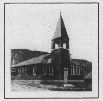
Church built for miners in Sunrise by CF&I at cost of $3,400.
In the 1880s the area around what would become Sunrise was an important area in the mining of copper. In 1890, Charles A. Guernsey, after whom the nearby town of Guernsey, Wyoming is named, founded the Wyoming Railway and Iron Company to exploit iron mining in the area. In 1898, the Colorado Fuel and Iron company began leasing mining rights in the area to improve its supply of iron. In 1904 Colorado Fuel and Iron bought the entire Sunrise Mine.[3]
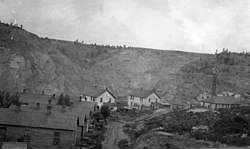
Colorado Fuel and Iron hoped to make Sunrise a model company town. In the early 1900s company-owned houses, boarding houses, depots, a school, churches, shops, and other structures were built. In response to the Ludlow Massacre, further improvements came to the town in the 1910s and 1920s in the form of better brick housing, a YMCA building, parks, a playground, better utility systems, a hospital, and other improvements. By 1928 the mine employed 547.[3]
Initially, the mining methods used at Sunrise were strip mining followed by glory-hole mining. In 1930, underground block caving mining was started, and by World War II all mining was underground.[3] Ore mined was partially processed on site and then sent to Colorado Fuel and Iron mills in Pueblo, Colorado.
Because of decreasing ore quality and problems in the domestic steel market, the town and mine were closed by Colorado Fuel and Iron in 1980. Over the lifetime of the mine 40 million tons of iron ore were produced, more than any other C.F. & I. mine.[3] The district was added to the National Register of Historic Places in 2005.[1]
Highways
WYO318 - runs west from Sunrise one mile to Hartville, where it meets WYO270, which connects to U.S. Route 26, five miles (8.0km) to the south.
This page is based on this Wikipedia article Text is available under the CC BY-SA 4.0 license; additional terms may apply. Images, videos and audio are available under their respective licenses.