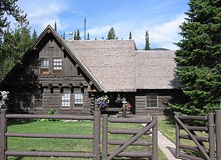
The Old Administrative Area Historic District, also known as Beaver Creek, is the former headquarters area of Grand Teton National Park. The complex of five houses, three warehouses and an administrative building were designed in the National Park Service rustic style between 1934 and 1939 and were built by the Civilian Conservation Corps and the Public Works Administration. As part of the Mission 66 program, the park headquarters were relocated to Moose, Wyoming in the 1960s.

The Goff Creek Lodge is a dude ranch in Shoshone National Forest on the east entrance road to Yellowstone National Park. The ranch was probably established c. 1910 by Tex Kennedy. Built in typical dude ranch style with a rustic log lodge surrounded by cabins, its period of significance extends from 1929 to 1950.
The Quintin Blair House in Cody, Wyoming was designed by Frank Lloyd Wright and built in 1952-53. The house is an example of Wright's "natural house" theme, emphasizing close integration of house and landscape. It is the only Wright building in Wyoming.
The Agate Basin Site is a Paleoindian archeological site in Niobrara County, Wyoming. The location was discovered by William H. Spencer of Spencer, Wyoming in 1916, who found well-preserved stone blades and points in Moss Agate Arroyo. In 1941 Spencer mentioned the find to Robert E. Frison, a deputy game warden at Newcastle, who visited the site and contacted Dr. Frank H.H. Roberts of the Bureau of American Ethnology at the Smithsonian Institution. Roberts visited the site in 1942, but it would not be until 1959 that a full investigation began by the University of Wyoming on what proved to be a buffalo kill site. Further investigation took place under the direction of Dr. George C. Frison.
The Basin Oil Field Tipi Rings were first noted during a cultural resource inventory along a coal slurry pipeline route. Located near the confluence of Caballo Creek and the Belle Fourche River in northeastern Wyoming, the site primarily represents a Middle Missouri encampment in the Late Prehistoric or Protohistoric periods. The site may also have been occupied in the Late Archaic period. The middle Missouri tradition includes elements of the Mandan, Hidatsa and Crow.
The Bishop Road Site in Campbell County, Wyoming is an archeological site along Piney Creek. It was discovered during surveys for a proposed coal slurry pipeline. The site contained buried lithic artifacts, bone fragments and hearths. Projectile points characteristic of the Late Archaic and Late Prehistoric periods were found, with possible early and middle Archaic points as well.
The HF Bar Ranch is located in Johnson County, Wyoming about 20 miles (32 km) northwest of Buffalo, Wyoming in the foothills of the Bighorn Mountains near Saddlestring, Wyoming. The ranch is a working cattle ranch comprising about 36 buildings, built between 1898 and 1921. The ranch is associated with Wyoming state senator and U.S. Congressman Frank O. Horton, who purchased it in 1911 with financial help from his investment banker brother-in-law and sister-in-law, Warren and Demia Gorrell. The Gorrells and their children spent summers in Wyoming, while the Hortons stayed year-round.

Teapot Rock is a distinctive sedimentary rock formation in Natrona County, Wyoming that lent its name to a nearby oil field that became notorious as the focus of a bribery scandal during the Presidential administration of Warren G. Harding, the Teapot Dome scandal. The site was listed on the National Register of Historic Places in 1974.
The Calpet Rockshelter, also known as the Overlook Rockshelter and Archeological Site 48SU354 is an archeological site in Sublette County, Wyoming. The site includes an overhanging rock outcrop at the base of a butte that was used by Native Americans and European-Americans. The Native American use includes occupation by the Shoshone. A number of surface artifacts have been found and at least two buried cultural levels have been investigated from the Fremont and late Prehistoric-period Shoshone. Fremont, Prehistoric, Protohistoric and Historic-period visitation is documented at nine petroglyph panels.
The Arch Creek Petroglyphs, also known as Site 48CK41 are Native American rock art figures located in Crook County, Wyoming. The site, in the southern Black Hills, is unusual in featuring comparatively long, narrow line figures incised on the rock, compared to more common V-necked anthropomorphs and shield figures. The site is particularly well preserved and is protected.
Several sections of the Bozeman Trail in Wyoming are listed on the National Register of Historic Places. Typically there are sections of trail that are concentrated at geographic features such as fords or crossings of divides, where the trail consolidates from a broad swath of parallel, poorly defined paths to a small area where remnants of the trail are visible.
The Bear Creek Ranch Medicine Wheel is a Native American medicine wheel near Greybull, Wyoming. The Bear Creek Ranch wheel is a circular arrangement of stones arranged around a central circle, with radiating lines of stones from the inner to the outer circles arranged in a spoke-like manner. The medicine wheel was placed on the National Register of Historic Places on May 4, 1987.
The Hanson Site includes two separate areas of Paleoindiian acheological sites in the northern Bighorn Basin of Wyoming. The southern Hanson I site was investigated first in 1973, finding evidence of tool working and stone flakes at a campsite. The northern Hanson II site is larger and includes the sites of lodges. Activity in these areas dates to 10,700 +/- 670 years ago to 10,080 +/- 300 years ago. The Hanson site is also of interest in paleontology, with animal fossil remains at deeper levels. The site was placed on the National Register of Historic Places on December 15, 1978.
Medicine Lodge State Archeological Site is a Wyoming state park that interprets the Medicine Lodge Creek Site, a prehistoric Native American archeological site near Hyattville, Wyoming. It is administered by the Wyoming Division of State Parks and Historic Sites. The site is at the base of a steep limestone outcropping near the point where the dry and running portions of Medicine Lodge Creek join. for a protected location with ready access to water. The site includes petroglyphs and pictographs on the rock face. Excavations starting in the 1970s have found twelve levels of habitation in 10.5 feet of stratum, ranging from historic times to 8300 years before the present. The site comprises a portion of the former Wickwire Ranch, which was purchased by the state in 1972 and became to Medicine Lodge Wildlife Habitat Management Area of 12,000 acres (4,900 ha). The archeological site was designated in 1973. The site is managed as a state park, with campgrounds and a visitor center. It was added to the National Register of Historic Places on July 5, 1973.
The Sage Creek Station Site is a former way station on the Overland Trail in Carbon County, Wyoming. Constructed about 1862, the station was built of logs with an adobe fireplace and a dirt roof over pole rafters. The site burned on June 8, 1865, but may have been rebuilt. All that remains of the station are its foundations. The site was placed on the National Register of Historic Places on December 6, 1978.
The Muddy Creek Archeological Complex is an archeological location Carbon County, Wyoming. The complex's three sites are dated to the Late Plains Archaic period. Stone points place the users of the site in the Besant Cultural Complex, representing one of the southernmost Besant sites. The sites were was bison hunting and processing locations and feature many bison remains, as well as tipi rings. The complex was placed on the National Register of Historic Places on May 16, 2012.
The Arapahoe and Lost Creek Site is an archeological site in Sweetwater County, Wyoming. Site includes evidence of settlement over a 9 kilometres (5.6 mi) stretch along the terraces of Arapahoe Creek and Lost Creek. The site was used by Native Americans more or less continuously for 9000 years until about 1900. Site surveys indicate the presence of at least three dozen hearths, and buried features are believed to exist. The site was placed on the National Register of Historic Places on March 12, 1986.
The Dean Decker Site is an archeological site in Sweetwater and Fremont counties in Wyoming. The site extends for 6.5 kilometres (4.0 mi) along the terraces of Red Creek and Lower Sand Creek, with many Native American hearths and worked stone fragments. The site appears to have been used from the Middle Archaic Period to the Protohistoric Period. It was added to the National Register of Historic Places on March 12, 1986.
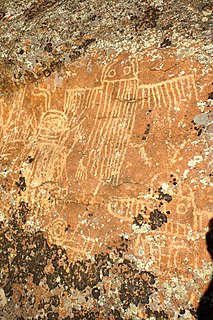
The Torrey Lake Petroglyph District extends for about 3.2 miles (5.1 km) along Torrey Creek in Fremont County, Wyoming. The site includes about 175 petroglyphs, as well as eleven lithic scatters and a sheep trap. The petroglyphs are in the Interior Line Style, or Dinwoody style, consistent with other rock at in central Wyoming. Site investigations have uncovered a number of petroglyphs that had previously been hidden under lichen. The site was placed on the National Register of Historic Places on October 4, 1993.
The Finley Site is an archeological site in Sweetwater County, Wyoming. The site was investigated beginning in 1940 when projectile points were found on the surface by Orion B. Finley in the vicinity of a stable section of the Killpecker Dune Field. The site dates to the late Paleoindian Period of about 9000 years before present. The projectile points from the Finley Site established the Eden point type, and included Scottsbluff Type I and II points, linking the cultures to the Cody Cultural Complex.

