Watertable control

Last updated

Watertable control is the practice of controlling the height of the water table by drainage. Its main applications are in agricultural land (to improve the crop yield using agricultural drainage systems) and in cities to manage the extensive underground infrastructure that includes the foundations of large buildings, underground transit systems, and extensive utilities (water supply networks, sewerage, storm drains, and underground electrical grids).

Contents

Description and definitions

Subsurface land drainage [1] aims at controlling the water table of the groundwater in originally waterlogged land at a depth acceptable for the purpose for which the land is used. The depth of the water table with drainage is greater than without.

Figure 1. Drainage parameters in watertable control DrainSection2.png
Figure 1. Drainage parameters in watertable control
Figure 2. Crop yield (Y) and depth of water table (X in dm) R-3VAR1.JPG
Figure 2. Crop yield (Y) and depth of water table (X in dm)

Purpose

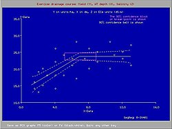
In agricultural land drainage, the purpose of water table control is to establish a depth of the water table (Figure 1) that does no longer interfere negatively with the necessary farm operations and crop yields (Figure 2, made with the SegReg model, see the page: segmented regression).
In addition, land drainage can help with soil salinity control.
The soil's hydraulic conductivity plays an important role in drainage design.

The development of agricultural drainage criteria [3] is required to give the designer and manager of the drainage system a target to achieve in terms of maintenance of an optimum depth of the water table.

Figure 3. Positive and negative effects of land drainage DrDiagram.JPG
Figure 3. Positive and negative effects of land drainage

Optimization

Optimization of the depth of the water table is related to the benefits and costs of the drainage system (Figure 3). The shallower the permissible depth of the water table, the lower the cost of the drainage system to be installed to achieve this depth. However, the lowering of the originally too shallow depth by land drainage entails side effects. These have also to be taken into account, including the costs of mitigation of negative side effects. [3]

Figure 4. Example of effects of drain depth DrainTable.jpg
Figure 4. Example of effects of drain depth

The optimization of drainage design and the development of drainage criteria are discussed in the article on drainage research.

Figure 4 shows an example of the effect of drain depth on soil salinity and various irrigation/drainage parameters as simulated by the SaltMod program. [4]

History

Historically, agricultural land drainage started with the digging of relatively shallow open ditches that received both runoff from the land surface and outflow of groundwater. Hence the ditches had a surface as well as a subsurface drainage function.
By the end of the 19th century and early in the 20th century it was felt that the ditches were a hindrance for the farm operations and the ditches were replaced by buried lines of clay pipes (tiles), each tile about 30 cm long. Hence the term "tile drainage".
Since 1960, one started using long, flexible, corrugated plastic (PVC or PE) pipes that could be installed efficiently in one go by trenching machines. The pipes could be pre-wrapped with an envelope material, like synthetic fibre and geotextile, that would prevent the entry of soil particles into the drains.
Thus, land drainage became a powerful industry. At the same time agriculture was steering towards maximum productivity, so that the installation of drainage systems came in full swing.

Figure 5. Controlled drainage DrainageControl2.jpg
Figure 5. Controlled drainage

Environment

As a result of large scale developments, many modern drainage projects were over-designed, [5] while the negative environmental side effects were ignored. In circles with environmental concern, the profession of land drainage got a poor reputation, sometimes justly so, sometimes unjustified, notably when land drainage was confused with the more encompassing activity of wetland reclamation. Nowadays, in some countries, the hardliner trend is reversed. Further, checked or controlled drainage systems were introduced, as shown in Figure 5 and discussed on the page: Drainage system (agriculture).

Drainage design

Figure 6. Geometry of a well drainage system WellDrain2.png
Figure 6. Geometry of a well drainage system

The design of subsurface drainage systems in terms layout, depth and spacing of the drains is often done using subsurface drainage equations with parameters like drain depth, depth of the water table, soil depth, hydraulic conductivity of the soil and drain discharge. The drain discharge is found from an agricultural water balance.
The computations can be done using computer models like EnDrain, which uses the hydraulic equivalent of Joule's law in electricity. [6]

Drainage by wells

Subsurface drainage of groundwater can also be accomplished by pumped wells (vertical drainage, in contrast to horizontal drainage). Drainage wells have been used extensively in the Salinity Control and Reclamation Program (SCARP) in the Indus valley of Pakistan. Although the experiences were not overly successful, the feasibility of this technique in areas with deep and permeable aquifers is not to be discarded. The well spacings in these areas can be so wide (more than 1000m) that the installation of vertical drainage systems could be relatively cheap compared to horizontal subsurface drainage (drainage by pipes, ditches, trenches, at a spacing of 100m or less). For the design of a well field for control of the water table, the WellDrain model [7] may be helpful.

Classification

A classification of drainage systems is found in the article Drainage system (agriculture).

Effects on crop yield

Yield of sugarcane versus depth of the water table, Australia. The critical depth is 0.6 m. Rudd PartReg.png
Yield of sugarcane versus depth of the water table, Australia. The critical depth is 0.6 m.

Most crops need a watertable at a minimum depth because at shallower depths the crop suffers a yield decline. [10] For some important food and fiber crops a classification was made: [11]

Crop and locationTolerance
DWT(cm)
ClassificationExplanation
Wheat, Nile Delta, Egypt45Very tolerantResists shallow water tables
Sugar cane, Australia60TolerantThe water table should be deeper than 60 cm
Banana, Surinam70Slightly sensitiveYield declines at water tables < than 70 cm deep
Cotton, Nile Delta90SensitiveCotton needs dry feet, water table should be deep
(Where DWT = depth to water table)

See also

Related Research Articles

Aquifer Underground layer of water-bearing permeable rock

An aquifer is an underground layer of water-bearing permeable rock, rock fractures or unconsolidated materials. Groundwater from aquifers can be extracted using a water well. The study of water flow in aquifers and the characterization of aquifers is called hydrogeology. Related terms include aquitard, which is a bed of low permeability along an aquifer, and aquiclude, which is a solid, impermeable area underlying or overlying an aquifer, the pressure of which could create a confined aquifer.

Soil salinity The salt content in the soil

Soil salinity is the salt content in the soil; the process of increasing the salt content is known as salinization. Salts occur naturally within soils and water. Salination can be caused by natural processes such as mineral weathering or by the gradual withdrawal of an ocean. It can also come about through artificial processes such as irrigation and road salt.

Water table Top of a saturated aquifer, or where the water pressure head is equal to the atmospheric pressure

The water table is the upper surface of the zone of saturation. The zone of saturation is where the pores and fractures of the ground are saturated with water. It can also be simply explained as, the upper level, below which the ground is saturated.

Groundwater models are computer models of groundwater flow systems, and are used by hydrogeologists. Groundwater models are used to simulate and predict aquifer conditions.

Soil salinity control

Soil salinity control relates to controlling the problem of soil salinity and reclaiming salinized agricultural land.

Well drainage means drainage of agricultural lands by wells. Agricultural land is drained by pumped wells to improve the soils by controlling water table levels and soil salinity.

SahysMod

SahysMod is a computer program for the prediction of the salinity of soil moisture, groundwater and drainage water, the depth of the watertable, and the drain discharge in irrigated agricultural lands, using different hydrogeologic and aquifer conditions, varying water management options, including the use of ground water for irrigation, and several crop rotation schedules, whereby the spatial variations are accounted for through a network of polygons.

Drainage research is the study of agricultural drainage systems and their effects to arrive at optimal system design.

SaltMod

SaltMod is computer program for the prediction of the salinity of soil moisture, groundwater and drainage water, the depth of the watertable, and the drain discharge (hydrology) in irrigated agricultural lands, using different (geo)hydrologic conditions, varying water management options, including the use of ground water for irrigation, and several cropping rotation schedules. The water management options include irrigation, drainage, and the use of subsurface drainage water from pipe drains, ditches or wells for irrigation.

Surface irrigation

Surface irrigation is where water is applied and distributed over the soil surface by gravity. It is by far the most common form of irrigation throughout the world and has been practiced in many areas virtually unchanged for thousands of years.

An agricultural drainage system is a system by which water is drained on or in the soil to enhance agricultural production of crops. It may involve any combination of stormwater control, erosion control, and watertable control.

Hydrology (agriculture)

Agricultural hydrology is the study of water balance components intervening in agricultural water management, especially in irrigation and drainage.

Environmental impact of irrigation

The environmental impacts of irrigation relate to the changes in quantity and quality of soil and water as a result of irrigation and the effects on natural and social conditions in river basins and downstream of an irrigation scheme. The impacts stem from the altered hydrological conditions caused by the installation and operation of the irrigation scheme.

A leaching model is a hydrological model by which the leaching with irrigation water of dissolved substances, notably salt, in the soil is described depending on the hydrological regime and the soil's properties.
The model may describe the process (1) in time and (2) as a function of amount of water applied.
Leaching is often done to reclaim saline soil or to conserve a favorable salt content of the soil of irrigated land as all irrigation water contains salts.

Dewatering is the removal of water from solid material or soil by wet classification, centrifugation, filtration, or similar solid-liquid separation processes, such as removal of residual liquid from a filter cake by a filter press as part of various industrial processes.

This page shows statistical data on irrigation of agricultural lands worldwide.
Irrigation is the artificial abstraction of water from a source followed by the distribution of it at scheme level aiming at application at field level to enhance crop production when rainfall is scarce.

Drainage equation

A drainage equation is an equation describing the relation between depth and spacing of parallel subsurface drains, depth of the watertable, depth and hydraulic conductivity of the soils. It is used in drainage design.

Irrigation in Iran covers 89,930 km2 making it the fifth ranked country in terms of irrigated area.

Waterlogging (agriculture)

Waterlogging is the saturation of soil with water. Soil may be regarded as waterlogged when it is nearly saturated with water much of the time such that its air phase is restricted and anaerobic conditions prevail. In extreme cases of prolonged waterlogging, anaerobiosis occurs, the roots of mesophytes suffer, and the subsurface reducing atmosphere leads to such processes as denitrification, methanogenesis, and the reduction of iron and manganese oxides.

EnDrain

EnDrain is software for the calculation of a subsurface drainage system in agricultural land. The EnDrain program computes the water flow discharged by drains, the hydraulic head losses and the distance between drains, also obtaining the curve described by water-table level. Such calculations are necessary to design a drainage system in the framework of an irrigation system for water table and soil salinity control.

References

  1. Nosenko, P.P. and I.S. Zonn 1976. Land Drainage in the World. ICID Bulletin 25, 1, pp.65–70.
  2. Data provided by various authors on banana, cotton, sugarcane, and wheat response to shallow water tables
  3. 1 2 Agricultural Drainage Criteria, Chapter 17 in: H.P.Ritzema (2006), Drainage Principles and Applications, Publication 16, International Institute for Land Reclamation and Improvement (ILRI), Wageningen, The Netherlands. ISBN   90-70754-33-9. Download from : or directly as PDF :
  4. SaltMod, Description of Principles, User Manual, and Examples of Application. ILRI Special Report. International Institute for Land Reclamation and Improvement (ILRI), Wageningen, The Netherlands. Download from : or directly as PDF:
  5. Agricultural Land Drainage: a wider application through caution and restraint. In: ILRI Annual Report 1991, pp. 21–36, International Institute for Land Reclamation and Improvement (ILRI), Wageningen, The Netherlands. Download from : or directly as PDF :
  6. The energy balance of groundwater flow applied to subsurface drainage in anisotropic soils by pipes or ditches with entrance resistance, International Institute for Land Reclamation and Improvement (ILRI), Wageningen, The Netherlands. Download from: or directly as PDF :
    Paper based on: R.J. Oosterbaan, J. Boonstra and K.V.G.K. Rao, 1996, The energy balance of groundwater flow. Published in V.P.Singh and B.Kumar (eds.), Subsurface-Water Hydrology, p. 153-160, Vol.2 of Proceedings of the International Conference on Hydrology and Water Resources, New Delhi, India, 1993. Kluwer Academic Publishers, Dordrecht, The Netherlands.
    ISBN   978-0-7923-3651-8. Download as PDF :
    Download the EnDrain program from :
  7. Subsurface drainage by (tube)wells: well spacing equations for fully and partially penetrating wells in uniform or layered aquifers with or without anisotropy and entrance resistance. Paper explaining the basics of the WellDrain model, International Institute for Land Reclamation and Improvement (ILRI), Wageningen, The Netherlands. Download as PDF :
    Download the WellDrain program from :
  8. Rudd, A.V. and C.W Chardon 1977. The effects of drainage on cane yields as measured by water table height in the Machnade Mill area. In: Proceedings of the 44th Conference of the Queensland Society of Sugar Cane Technology, Australia.
  9. Software for partial regression with horizontal segment
  10. K.J.Lenselink et al. Crop tolerance to shallow watertables. On line:
  11. Nijland, H.J. and S. El Guindy 1984. Crop yields, soil salinity and water table depth in the Nile Delta. In: ILRI Annual Report 1983, Wageningen, The Netherlands, pp. 19–29. On line: